Provinces of Saudi Arabia
The Provinces of the Kingdom of Saudi Arabia are the highest administrative division in the Kingdom and represent specific administrative supervision zones. The Kingdom consists of thirteen administrative provinces.
Administration of regions
Before 1992, the Kingdom was composed of six main regions: Najd, Hejaz, Aseer, Jazan, Najran, and Hail. These regions were governed by sixty-four Governors according to the Law of Governors and Administrative Councils, which was issued in 1940 and specified the powers and responsibilities of Governors. The term province officially emerged with the issuance of the Law of Provinces in 1992, which stipulated that each province would have a Governor with the rank of minister to manage its affairs and represent it before the Minister of Interior. Each province consists of governorates and centers, with one of the governorates serving as the administrative capital and the seat of the emirate.
Naming of Saudi Arabia's provinces
Eight of the Kingdom's provinces derive their names from the official name of their administrative capitals. These are: Riyadh Province, represented by the capital, Riyadh; Makkah al-Mukarramah Province with its administrative capital Makkah al-Mukarramah City; Hail Province with its capital Hail City; Tabuk Province with its administrative capital Tabuk City; al-Bahah Province with its administrative capital al-Bahah City; Jazan Province with its administrative capital Jazan City; Najran Province with its administrative capital Najran City; and al-Madinah al-Munawwarah Province with its capital al-Madinah al-Munawwarah. Conversely, the names of the provinces of Qassim, Aseer, the Eastern Province, al-Jawf, and the Northern Borders reflect the administrative supervision of these provinces and do not mirror the names of their administrative capitals.
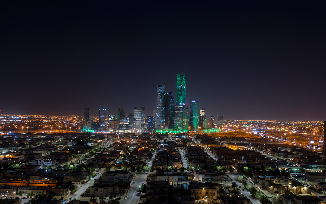
Riyadh Province
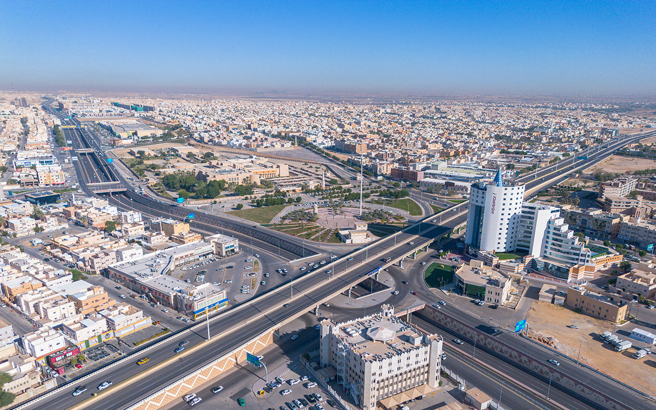
It is one of the thirteen administrative provinces in the Kingdom and is home to the country’s capital, Riyadh, as well as government entities and international organizations in the Kingdom. It is the second-largest administrative province by area and the most populous according to the 2022 Saudi Census.
Riyadh Province location
Riyadh Province is located in the center of the Kingdom, bordered to the east and northeast by the Eastern Province, to the north by Qassim Province, to the south by Najran and Aseer Provinces, and to the west by Makkah al-Mukarramah Province and part of al-Madinah al-Munawwarah Province. Riyadh City serves as its administrative capital, the seat of the emirate, the province’s metropolis, and the most populous governorate.
Area of Riyadh Province
The area of Riyadh Province is approximately 380,000 km², accounting for about 19.4 percent of the Kingdom’s total area. Although the name Riyadh is synonymous with its administrative capital, Riyadh City occupies less than 1 percent of the province’s land. Consequently, it is the most densely populated city and governorate in the Kingdom, with more than seven million residents, representing over a quarter of the Kingdom’s population and 81.6 percent of the Riyadh Province population.
Population of Riyadh Province
The population of Riyadh Province is 8,591,748, according to the 2022 Saudi Census, making up 26.7 percent of the Kingdom’s population. The annual population growth rate is 2.7 percent, the highest in the Kingdom after Makkah al-Mukarramah Province.
History of Riyadh Province
Riyadh Province holds historical significance as it encompasses two historic capitals within its borders: Ad-Dir'iyyah Governorate, the capital of the First Saudi State, and Riyadh City, the capital of the Second Saudi State and later the Kingdom. It is also historically and geographically connected to the Sultanate of Najd, whose boundaries correspond to the current geographical area of Riyadh Province. From here, efforts to reunify the rest of the Kingdom's provinces were launched.
Riyadh Province still preserves examples of ancient Najdi architecture, such as al-Turaif District in ad-Dir'iyyah Governorate, which is listed as a UNESCO World Heritage site as the largest mud-brick city in the world. It features palaces and an archaeological city in ad-Dir'iyyah. Riyadh Province also contains historical landmarks that, in addition to their historical importance, serve as tourist attractions. These include al-Bujairi district, the historical and scientific center in ad-Dir'iyyah, al-Masmak Palace, an iconic historic palace in the Kingdom built in 1865, and the site of the Battle of Riyadh's recapture. It now serves as an open museum housing archaeological artifacts. Additionally, al-Murabba Palace, the residence of the Kingdom's founding King Abdulaziz Bin Abdulrahman Al Saud, is located in the province.
Riyadh Province topography
Riyadh Province is located on al-Safra Plateau in Najd region. The highest elevation in the province is six hundred m above sea level, near az-Zulfi Governorate to the north. The Tuwaiq Mountain stretches 1,200 km with heights ranging between eight hundred and one thousand m. The western face of the mountain is characterized by steep slopes, while the eastern slopes are more gradual, ending in the sands of the Empty Quarter to the south.
The climate in Riyadh Province varies from one governorate to another due to differences in topography. Generally, it is a dry continental climate, hot in summer and cold in winter, with most rainfall occurring in the winter and being moderate.
Universities in Riyadh Province
Riyadh has the highest number of public universities among the Kingdom's provinces, with eight public universities. Two of these universities are ranked among the top one thousand universities in the world for 2023, according to the QS World University Rankings: Princess Nourah University and King Saud University. Five universities are located in the administrative capital, while the remaining universities are distributed across other governorates.
Governorates of Riyadh Province
In the seventeenth century, the name 'Riyadh' was given to a group of villages located within a certain area. On March 1, 1992, the Law of Provinces was issued, establishing the provinces of the Kingdom, including Riyadh, which comprises twenty-two governorates. This makes Riyadh the province with the largest number of governorates in the Kingdom. In addition to the emirate's seat in Riyadh, it includes: Ad-Dir'iyyah, al-Kharj, al-Dawadmi, al-Majma'ah, al-Quway'iyah, Wadi al-Dawasir, al-Aflaj, az-Zulfi, Shaqra, Hawtat Bani Tamim, al-Ghat, Afif, al-Sulayyil, Dhurma, al-Muzahimiyah, Rumah, Thadiq, Huraymila, al-Hareeq, Murat, ad-Dilam, and ar-Rayn, as well as 504 centers. Al-Sulayyil Governorate is the largest governorate in the province in terms of area and the third-largest among the major governorates in the Kingdom. Prince Faisal Bin Bandar Bin Abdulaziz was appointed as the Governor of Riyadh Province in 2015.
The primary means of transportation between governorates within Riyadh Province is by car. The nearest governorate to the administrative capital is ad-Dir'iyyah, located twenty-three km away, while the farthest governorate in the province, Wadi ad-Dawasir Governorate, is 613 km away. King Khalid International Airport, situated north of the administrative capital, Riyadh, serves approximately 28.5 million passengers annually. Additionally, the "Riyadh Metro" project, which connects eighty-five stations across the capital, serves high-density neighborhoods and important locations, including government entities, with a total length of 176 km.
Projects in Riyadh Province
Riyadh Province, represented by the capital Riyadh, is considered a model for smart cities and a promising destination among the Kingdom's provinces. According to the semi-annual report of the Follow-up Program for Riyadh Region Projects Report issued by the High Commission for the Development of Riyadh City (the Royal Commission for Riyadh City) in 2016, 4,360 projects have been established in the sectors of services, public utilities, housing, transportation, roads, environment, and economic development. The megaprojects are part of the Saudi Vision 2030 plans, including King Salman Park in central Riyadh, the Sports Boulevard project connecting east and west Riyadh with a length of 135 km, the Green Riyadh project covering 30.35 percent of the capital's area, and the Riyadh Art project, designed to make Riyadh an open-air art gallery.
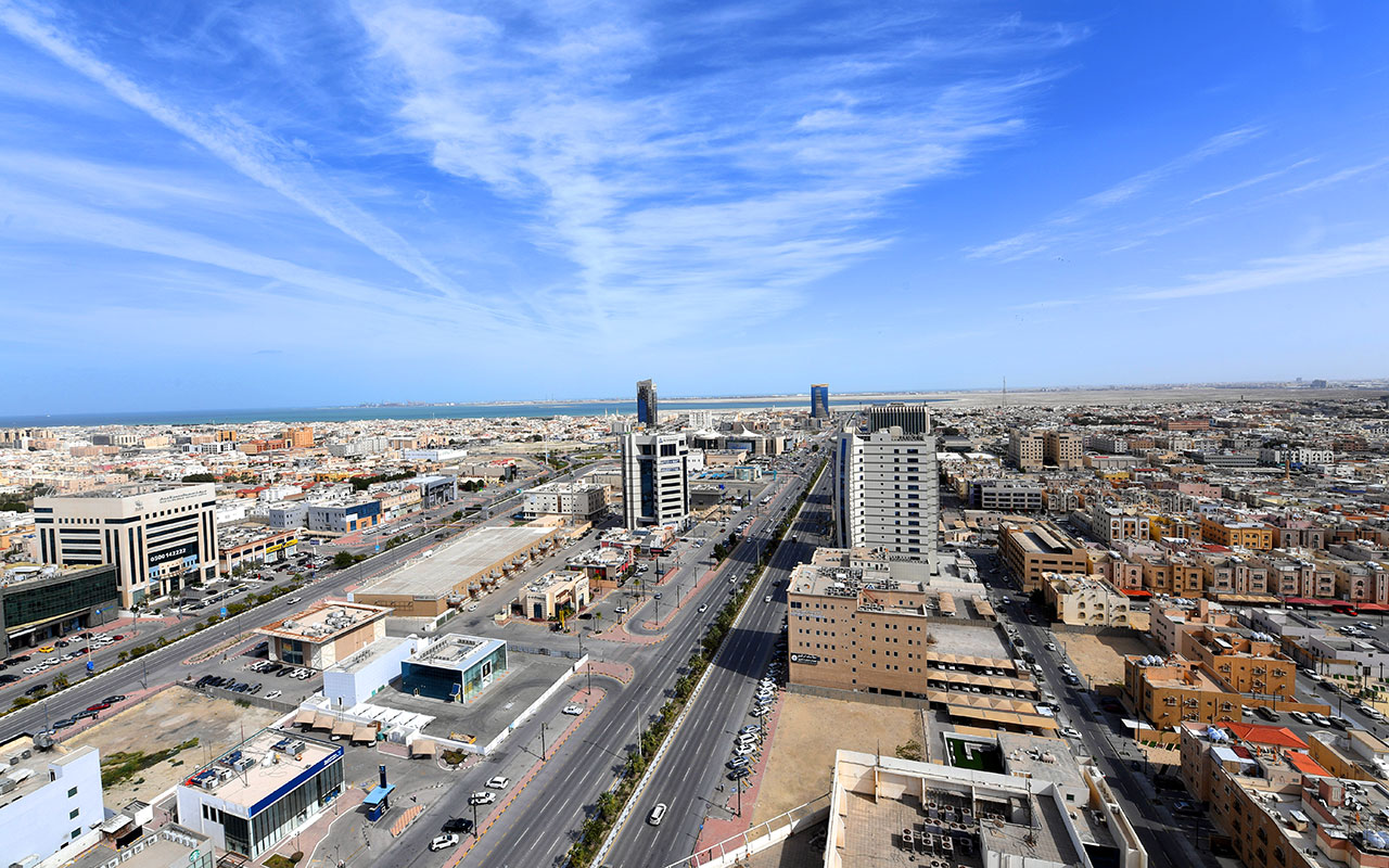
Eastern Province
It is the largest of the thirteen administrative provinces in the Kingdom and the headquarters of Saudi Aramco, the world's largest oil exporter. The province boasts three globally recognized industrial beacons by the World Economic Forum and houses eleven crude oil production fields, which account for 68 percent of the Kingdom's exports. It is named the Eastern Province given its location within the Kingdom.
Eastern Province location
The Eastern Province is located in the eastern part of the Kingdom, bordered internally by five administrative provinces: Najran Province to the south, Riyadh and Qassim Provinces to the west, and Hail and the Northern Borders Provinces to the north. Administratively, it comprises twelve governorates in addition to Dammam City, its capital and the seat of the emirate. Al-Ahsa Governorate constitutes the largest part of its area. Prince Saud Bin Naif Bin Abdulaziz Al Saud has governed the emirate since January 13, 2013.
Eastern Province area
The area of the Eastern Province is 540,000 km², accounting for 27 percent of the Kingdom's total area. It consists of a desert plain that shares borders with all the Gulf Cooperation Council countries (GCC), as well as Iraq, giving it the longest border line of all the Kingdom's provinces at 1,950 km.
Eastern Province climate
The Eastern Province records the lowest temperatures in winter, from November to February, reaching as low as four degrees Celsius. During the period between May and August, temperatures rise to forty-six degrees Celsius. The Eastern Province is also known for its caves and caverns, which maintain a constant temperature throughout the year.
Eastern Province population
The Eastern Province is the third most populous province in the Kingdom and the most stable in terms of population growth rates, consistently representing 14 percent of the Kingdom's population since 1999. According to the 2022 Saudi Census, its population is approximately 5,125,254. It is one of the provinces with the highest proportion of young people in the Kingdom, according to 2019 statistics. More than half of the population in the Eastern Province are Saudis, making up 57.56 percent of the total population, with 42 percent of them residing in Dammam City and al-Ahsa Governorate. Despite this, the province does not have a high population density due to its vast area, allowing nine people to live in one km² of its land.
Geographical features of the Eastern Province
The Eastern Province is among the most diverse provinces in the Kingdom in terms of wildlife. The geographic location of the province and its vast expanses combine desert areas, coastal areas, and watercourses.
It is also one of the provinces in the Kingdom that includes habitable and inhabited islands, alongside Jazan Province in the southwestern part of the Kingdom, such as Tarout Island, Jana Island, and the largest, Abu Ali Island, which covers an area of fifty-nine km².
Eastern Province economy
According to global development indicators, the Eastern Province registers high human development rates in the Kingdom. The average income per capita in the province is SAR17,872, the highest in the Kingdom according to the General Authority for Statistics in 2018. Each resident in the Eastern Province can access 378 L of water daily.
Due to housing the world’s largest oil facilities, higher education in the province began with the establishment of King Fahd University of Petroleum and Minerals in 1963, which later became a university and is one of the public universities in the province.
Beyond oil, the construction, trade, and manufacturing sectors dominate the economy of the Eastern Province, employing around 63 percent of the workforce across various sectors and 12 percent of the total population. The agricultural sector follows, with the Eastern Province ranking third in the number of agricultural holdings in the Kingdom after Aseer and Makkah al-Mukarramah Provinces. Additionally, the province is known for pearl trading, fishing, handicrafts, and shipbuilding.
The Eastern Province is also the starting point for the Kingdom’s transition to a knowledge-based economy, moving away from reliance on oil as the sole income source. The first oil well in the Kingdom, known as the Well of Prosperity, is located in the province. Furthermore, King Abdulaziz Center for World Culture "Ithra" is a government center fostering cultural activities in Dhahran City.
Tourism in the Eastern Province
The Eastern Province is one of the tourist provinces in the Kingdom, served by three airports. However, 89 percent of visitors prefer to arrive by road, which can be attributed to the diverse urban areas on its borders and ease of access. Dammam City is connected to the capital, Riyadh, by a railway line inaugurated in 1951, stretching 450 km.
History of the Eastern Province
The Eastern Province is a modern name for an ancient history of countries that existed on various parts of its land over five thousand years BC. It acquired its current name in 1992 with the issuance of the Law of Provinces, which divided the Kingdom into thirteen administrative provinces.
The province has been a rich tributary that supported the civilizations of Mesopotamia, the Levant, and India. It is one of the ancient inhabited areas in the Arabian Peninsula, having witnessed numerous historical periods under names such as Jerrha, Hajar, and the Bahrain region. The land has been home to various peoples, including the Amalek, Phoenicians, and Thamud, due to its abundant springs, wells, and fertile lands. Its location between the outside world and the inner regions of the Arabian Peninsula made it a caravan passage and a commercial hub.
The Eastern Province includes al-Ahsa Oasis, which was added to the UNESCO World Heritage Sites list in 2018 as one of the largest old palm oases in the world. Al-Ahsa is classified as a cultural and historical tourism destination, having been selected as the Arab Tourism Capital for 2019 by the Arab Ministerial Council for Tourism.
Al-Ahsa contains historical landmarks, including Jawatha Mosque, the second mosque where Friday prayers were held after the Mosque of Prophet Muhammad, peace be upon him (PBUH), and al-Uqayr Port, the oldest seaport in the Kingdom, serving the province since the first millennium BC. After the discovery of oil fields, it became one of the Kingdom's landmarks and a venue for receiving delegations and conducting negotiations.
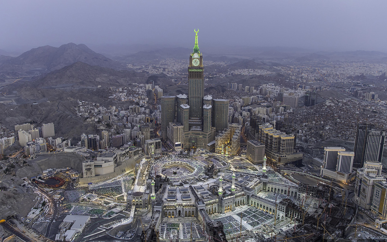
Makkah al-Mukarramah Province
It is one of the thirteen administrative provinces in the Kingdom, and the fourth largest in terms of area. Located in the western part of the Kingdom, it is bordered to the west by Riyadh Province, to the north by al-Madinah al-Munawwarah Province, and to the south by al-Bahah and Aseer Provinces.
The province has been governed by Prince Khalid al-Faisal since 2015. It is the only administrative province in the Kingdom that was under royal administration for thirty-four years, governed by King Faisal Bin Abdulaziz Al Saud when he was the deputy of King Abdulaziz Bin Abdulrahman Al Saud, and later as Crown Prince during the reign of his brother, King Saud Bin Abdulaziz Al Saud.
Religious significance of Makkah al-Mukarramah Province
Makkah al-Mukarramah Province, represented by its administrative capital, is a central destination in the lives of more than a billion people around the world. Within its borders lies the Grand Mosque, the Qibla for Muslims worldwide and the focal point of their prayers. The administrative capital of the province is Makkah al-Mukarramah City.
In fact, 2 percent of the province's land consists of sacred places that are uninhabited and designated for performing religious rites during the Hajj season. The province also hosts the headquarters of the Muslim World League and the Organization of Islamic Cooperation, the second-largest international organization by membership numbers.
During the 2023 Hajj season, Makkah al-Mukarramah City received 1,845,045 pilgrims, including 1,660,915 who came from outside the Kingdom through various entry points. The initiative to extend the Umrah season succeeded in increasing the number of Umrah pilgrims from 7.42 million in 2018 to 8.2 million in 2020 from outside the Kingdom. In 2023, the Kingdom achieved a record number of Umrah pilgrims, reaching 13.5 million.
In addition to its religious importance, Makkah al-Mukarramah Province combines tourism and economic significance. Located on its coast is the King Abdullah Economic City, one of the largest economic cities in the Kingdom, covering an area of approximately 181 million m². The province also includes Jeddah Islamic Port and King Abdullah Port, both ranked among the world's top one hundred ports.
Makkah al-Mukarramah Province population
Among the thirteen provinces of the Kingdom, Makkah al-Mukarramah Province ranks second in terms of population, with approximately 8,021,463 residents according to the 2022 Saudi Census. The population growth rate was around 2.8 percent annually according to 2017 statistics. The province spans an area of 137,000 km².
Unlike other provinces in the Kingdom, the population in the administrative capital, Makkah al-Mukarramah City, constitutes only 30.3 percent of the total population of the province. In contrast, 3,751,722 people, or 46.8 percent of the province's population, reside in Jeddah Governorate. This population is equivalent to the total population of six administrative provinces in the Kingdom, making Jeddah the second most populous governorate in the Kingdom.
Makkah al-Mukarramah Province contributes 13 percent to the Kingdom’s gross domestic product (GDP), ranking second after Riyadh Province in the number of economically active residents at 22 percent. It also ranks second in the accommodation of 28 percent of family companies, which employ about 52 percent of the total workforce in the Kingdom.
Climate of Makkah al-Mukarramah Province
The varying environmental conditions lead to differences in the prevailing climate across the cities of Makkah al-Mukarramah Province. For example, although the province overlooks the Red Sea coast, Makkah al-Mukarramah City is not significantly affected by the sea, unlike Jeddah City, which is directly on the coast and experiences higher humidity levels. Elevation also significantly impacts the climate, with Taif Governorate recording the lowest temperatures in the province. Generally, temperatures in Makkah al-Mukarramah Province are high during the summer months from June to August, while they drop during the winter months from December to February.
Geographical features of Makkah al-Mukarramah Province
Despite being part of the Arabian Shield, known for its scarcity of deep water resources but renewable surface water, Makkah al-Mukarramah Province ranks first in the highest storage capacity for dam water, with a storage capacity of 861,118,413 m³, accounting for 36 percent. It also ranks second among the Kingdom’s provinces in the number of agricultural holdings at 21.3 percent.
Harrat makes up 16 percent of its land, and its coastline stretches 610 km.
Jeddah Governorate is widely known for its waterfronts but ranks second in coastline length within the province, following al-Lith Governorate, which has the longest coastline in the province at two hundred km.
Governorates of Makkah al-Mukarramah Province
The governorates of Jeddah and Taif, along with the administrative capital, represent urban areas within the province. Both Jeddah and Taif Governorates are located within one hundred km of the Grand Mosque. Al-Qunfudhah is the farthest governorate from the administrative capital.
Taif Governorate is known as a distinctive summer resort in the Kingdom and is the site of Souq Okaz, one of the most important and largest cultural gatherings in the Arabian Peninsula, dating back to 501.
Northwest of Makkah al-Mukarramah Province lies Historic Jeddah City, a city listed as a UNESCO World Heritage site for its modern infrastructure while retaining the historic design of its neighborhoods and streets.
The province is served by King Abdulaziz International Airport in Jeddah, which is 108 km from the Grand Mosque. However, visitors can reach Makkah al-Mukarramah in about twenty minutes via the Haramain High-Speed Railway, which connects Makkah, Jeddah, King Abdulaziz International Airport, King Abdullah Economic City, and al-Madinah al-Munawwarah Province. This comes in addition to Taif International Airport.
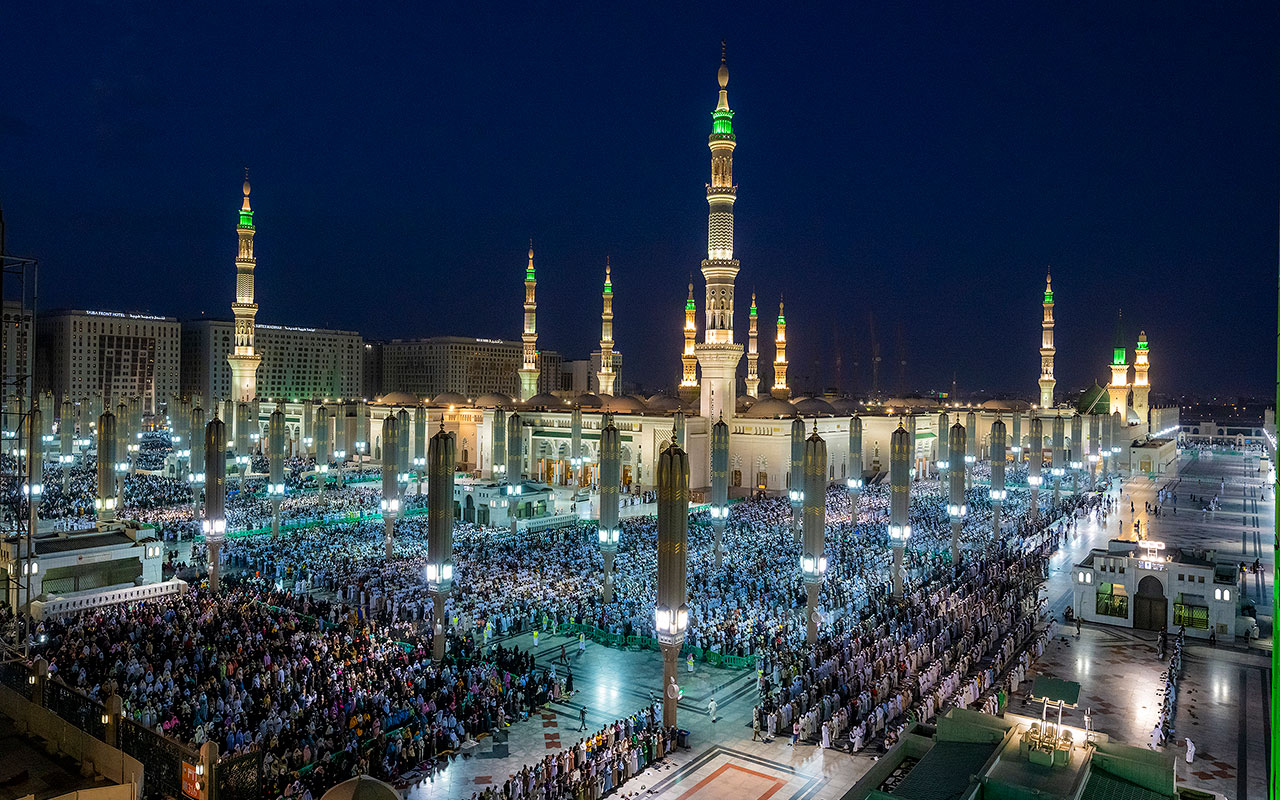
Al-Madinah al-Munawwarah Province
It is one of the thirteen administrative provinces in the Kingdom, where Prophet Muhammad (PBUH) resided, and it is home to the Prophet's Mosque. Al-Madinah al-Munawwarah Province is the third largest in terms of total area among the Kingdom's provinces. It is located in the western part of the Kingdom, bordered to the south by Makkah al-Mukarramah Province, to the north by Tabuk Province, to the east by Riyadh, Qassim, and Hail Provinces, and to the west by the Red Sea. Al-Madinah al-Munawwarah City serves as its administrative capital and the seat of the emirate. Prince Salman Bin Sultan Bin Abdulaziz Al Saud was appointed governor of the province in 2023.
Area of al-Madinah al-Munawwarah Province
The area of al-Madinah al-Munawwarah Province is 150,000 km², covering 7.7 percent of the Kingdom's land.
Population of al-Madinah al-Munawwarah Province
Among the thirteen provinces of the Kingdom, al-Madinah al-Munawwarah Province ranks fourth in terms of population, with 2,137,983 residents, accounting for 6.6 percent of the Kingdom's total population according to the 2022 Saudi Census. It has the third-highest population growth rate among the Kingdom's provinces, following Makkah al-Mukarramah and Riyadh Provinces, with an annual growth rate of 2.52 percent as per 2017 statistics.
Governorates of al-Madinah al-Munawwarah Province
The administrative structure of al-Madinah al-Munawwarah Province was established in 1992. The province includes eight governorates: Yanbu, al-Ula, al-Mahd, Badr, Khaybar, al-Hanakiyyah, al-'Is, and Wadi al-Far', in addition to its administrative capital and the seat of the emirate, al-Madinah al-Munawwarah City. Al-Madinah al-Munawwarah Province has a coastline of two hundred km along the Red Sea. However, only 18 percent of its population resides on the coast, while 69.1 percent of the population is concentrated in its administrative capital.
Religious significance of al-Madinah al-Munawwarah Province
Al-Madinah al-Munawwarah Province is deeply connected to the early period of Islam, the Hadith, and Islamic events. It is home to the Prophet Muhammad (PBUH) City, the first city and capital of Islam. The city houses the Prophet's Mosque, the second holiest site in Islam after the Grand Mosque in Makkah al-Mukarramah, and the second largest mosque in the world in terms of area and capacity after the Grand Mosque. The province also includes Quba Mosque, the first mosque built in Islam.
Al-Madinah al-Munawwarah contains several significant religious sites and landmarks, attracting hundreds of thousands of visitors, especially during the Hajj season.
Climate of al-Madinah al-Munawwarah Province
The climate in al-Madinah al-Munawwarah Province is desert-like and dry, characterized by hot summers and cold winters, with mild temperatures in the spring and fall seasons. The coastal governorates experience higher temperatures in the summer, accompanied by humidity. Rainfall occurs during the spring and winter seasons, with winter temperatures dropping to as low as ten degrees Celsius. In the summer, temperatures can reach up to forty-five degrees Celsius.
Universities in al-Madinah al-Munawwarah Province
Al-Madinah al-Munawwarah Province hosts two public universities: the Islamic University, specializing in Islamic studies, and Taibah University, which has received full unconditional institutional accreditation. Both universities are located in the administrative capital and have branches distributed across the province's governorates. In addition to a private university, which is Prince Muqrin Bin Abdulaziz University.
Tourism in al-Madinah al-Munawwarah Province
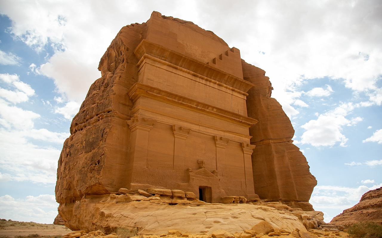
Al-Madinah al-Munawwarah Province is a prominent archaeological and tourist destination, represented by al-Ula Governorate located in the north of the province. Protected areas and archaeological sites make up 13 percent of the governorate's land. Al-Ula includes al-Hijr (Mada'in Salih), the capital of the Nabataeans, one of the oldest inhabited areas in the Kingdom, and the first Saudi heritage site listed on the UNESCO World Heritage list. It preserves artifacts, sites, and inscriptions dating back more than 1,700 years BC. The Kingdom has established a royal commission to preserve the heritage of al-Ula, chaired by the Crown Prince and Prime Minister, His Royal Highness Prince Mohammed Bin Salman Bin Abdulaziz.
The southern part of al-Madinah al-Munawwarah Province has significant economic and historical importance, home to Mahd ad-Dhahab mine, the largest and oldest gold mine in the Kingdom. It represents the first mining sector in the Kingdom, with exploration activities dating back over three thousand years.
The province is served by three airports: Prince Mohammed Bin Abdulaziz International Airport in al-Madinah al-Munawwarah, Prince Abdulmohsen Bin Abdulaziz Airport in Yanbu Governorate, and Prince Abdulmajeed Bin Abdulaziz Airport in al-Ula.
Qassim Province
Qassim Province location
Qassim Province is located in the central northern part of the Kingdom. It is approximately equidistant from the eastern and western coasts of the Kingdom, about 760 km away. The province shares borders with five administrative provinces: Hail Province to the north, al-Madinah al-Munawwarah Province to the west, Riyadh Province to the south, the Eastern Province to the east, and it meets the Northern Borders Province at its northwestern edge.
Governorates of Qassim Province
Qassim Province was administratively established in 1992 and encompasses thirteen governorates: Unaizah, ar-Rass, al-Mithnab, al-Bukayriyyah, al-Bada'i, al-Asyah, an-Nabhaniyyah, ash-Shimasiyah, Uyun al-Jiwa, Riyadh al-Khabra, Dhariah, Uqlat as-Suqur, and Abanat, in addition to its administrative capital, Buraydah. These governorates include a total of 152 centers. Buraydah, Unayzah, and ar-Rass are the main urban areas in the province. Qassim is one of five administrative provinces in the Kingdom whose name does not match that of its administrative capital.
Buraydah City serves as the administrative capital and the seat of the emirate. The province has been governed by Prince Faisal Bin Mishaal Bin Saud since 2015. Qassim Province covers an area of seventy-three thousand km², which is equivalent to 3.7 percent of the Kingdom's total area. This makes it one of the three smallest provinces in the Kingdom: Al-Bahah, Jazan, and then Qassim.
Climate of Qassim Province
Overall, the climate in Qassim Province is hot, with temperatures soaring seven months of the year, peaking in August and September. In the winter, temperatures gradually decrease to five degrees Celsius in some governorates during January and February. The province sees scant rainfall, limited mostly to spring and winter.
Despite being an inland province with infrequent rainfall, Qassim is classified as an agricultural area within the Kingdom. It is one of the most abundant provinces in terms of vegetation, alongside Hail Province. The province boasts the largest date palm farm in the world, covering an area of fifty-six km², and hosts a large date festival. Wadi Rumah, the longest valley in the Arabian Peninsula, runs through Qassim Province from west to east, stretching 510 km.
Population of Qassim Province
Qassim Province ranks seventh in population compared to other provinces in the Kingdom and sixth in population density. According to the 2022 Saudi Census, its population is approximately 1,336,179. Half of the population is concentrated in Buraydah City, accounting for 50.7 percent of the province's total population. Qassim is also one of the top five provinces in terms of growth rates in the Kingdom, with a growth rate of 2.31 percent according to 2017 statistics.
History of Qassim Province
Historically, Qassim Province served as a station for six historic pilgrimage and trade routes. The name of Qassim Province has been mentioned in much Arabic poetry, and it is the homeland of the pre-Islamic poet Antarah Ibn Shaddad.
Its strategic location granted it historical importance during the founding of the Saudi State. It was the second province to join the Saudi State in 1904, after Sudayr and al-Washm in Riyadh. The province witnessed several battles during the founding of the Kingdom and houses a special residence of the founding King Abdulaziz. This residence, known as King Abdulaziz Palace in Qibah, located in al-Asyah Governorate, is one of the largest historical palaces in the province.
Qassim has one public university, Qassim University, and is served by one airport, Prince Naif Bin Abdulaziz International Airport, with a capacity of seven hundred thousand passengers annually.
Northern Borders Province
Northern Borders Province location
The Northern Borders Province is located in the far northeastern part of the Kingdom. It shares borders with two countries: Iraq and Jordan to the north. It also borders four administrative provinces: the Eastern Province to the south, Qassim and Hail Provinces to the southwest, and al-Jawf Province to the west. Arar City serves as its administrative capital and the seat of the emirate. Prince Faisal Bin Khalid Bin Sultan has been the governor of the province since 2017.
Area of the Northern Borders Province
The Northern Borders Province covers an area of 104,000 km². It consists of three governorates in addition to its administrative capital, Arar City, making it the province with the fewest administrative divisions in the Kingdom.
Population of the Northern Borders Province
The Northern Borders Province is the second least populated province in the Kingdom, after al-Bahah Province, in terms of both population and population density. According to the 2022 Saudi Census, the population of the Northern Borders Province is approximately 373,577. The population growth rate is 2.17 percent annually, with Saudis making up about 72.63 percent of the total population.
Governorates of the Northern Borders Province
The Northern Borders Province was administratively established in 1992, with its administrative capital in Arar City. The province encompasses three governorates, all of which are located on international borders: Rafha, Turayf, and al-Uwayqilah. These governorates include a total of twenty-eight centers.
Climate of the Northern Borders Province
The climate in the Northern Borders Province is continental, characterized by significant variations in temperature. Summers are hot, while winters are extremely cold, with temperatures dropping below zero degrees Celsius during January and February, unlike other provinces in the Kingdom The province occasionally experiences snowfall in some highlands. Rainfall mainly occurs during the spring and winter seasons.
Economy of the Northern Borders Province
The mining industry is the third pillar of the Kingdom's economy, following the oil and petrochemical sectors, and is a significant contributor to the Kingdom’s investment sectors. The Northern Borders Province contains the world's third-largest phosphate reserves, and it is expected to become the second-largest producer of phosphate by 2024, holding 7 percent of the world's phosphate reserves.
Within the Northern Borders Province lies Wa'ad al-Shamal, a city dedicated to extracting valuable minerals. It spans an area of 440 km² and has an investment value exceeding SAR85 billion, funded by the Public Investment Fund, the Kingdom's main investment arm.
In addition to Wa'ad al-Shamal, City there is al-Jalamid phosphate mine in Hazm al-Jalamid village, the first discovered phosphate mine in the Kingdom, along with a sulfuric acid plant.
The Northern Borders Province was also one of the stations on the Tapline, which exported oil from the Kingdom to the world. The province contains five operational stations along the pipeline's route, establishing a civilized community amid the desert, significantly shaping the social, cultural, and economic dimensions of the province.
Historical significance of the Northern Borders Province
The Northern Borders Province gained its historical significance from its geographic location connecting the Kingdom with the outside world, as well as being a station for water and grazing centers on the Zubaydah Trail, the most significant historical trade and pilgrimage route. Its territory is now home to the four historic towns of Lina, Zubala, Luqa, and Umm Amarah.
Wildlife in the Northern Borders Province
The Northern Borders Province is classified as a natural habitat for various bird and wildlife species. It is abundant in bustards and peregrine falcons and features extensive grazing areas for camels and sheep. The province is a popular destination in the Kingdom for falconry.
The province includes three agricultural nature reserves: Ma'ila Valley, al-Owaisi, and al-Ghurabah. It also encompasses part of the "Harrat al-Harrah" Area, a key area within the King Salman Bin Abdulaziz Royal Reserve. The geological structure of the Arabian Plate covers most of its land, contributing to its rich botanical and mineral resources.
The Northern Borders Province is served by Arar Regional Airport, Rafha Airport, and Turayf Domestic Airport. Additionally, the North-South Railway connects the phosphate mines in the province to the ports on the Kingdom's coasts. It also hosts one university: Northern Border University.
Hail Province
Hail Province location
Hail Province is located in the north-central part of the Kingdom. It is bordered to the north by al-Jawf Province, to the east by the Northern Borders Province, to the west by Tabuk and al-Madinah al-Munawwarah Provinces, and to the south by Qassim Province. In its eastern part, it shares a junction point with the Eastern Province and the Northern Borders Province.
Governorates of Hail Province
Hail Province was administratively established in 1992, and its name reflects its administrative capital, Hail. The province consists of the administrative capital Hail City, which also serves as the seat of the emirate and comprises the largest part of its land, along with eight governorates: Baq'a, al-Ghazalah, ash-Shinan, as-Sulaymi, al-Ha'it, Samira', ash-Shamli, and Mawqaq. Additionally, it includes 110 centers. Prince Abdulaziz Bin Saad Bin Abdulaziz has governed the province since April 22, 2017. Hail is one of the provinces that has a development authority that collaborates with the municipality in managing its developmental and urban affairs.
Area and population of Hail Province
Hail Province covers an area of 120,000 km², accounting for 6.1 percent of the Kingdom's total area. Despite its relatively small size compared to the entire Kingdom, it is larger than the combined areas of three administrative provinces: al-Jawf, al-Bahah, and Jazan. According to the 2022 Saudi Census, the population of Hail Province is approximately 746,406. It ranks ninth in population growth rates, with an annual growth rate of 2.23 percent according to the 2017 statistics.
Hail City, the administrative capital and the seat of the emirate, is the most significant urban area in the province, housing 66.8 percent of the population.
Economic activity in Hail Province
Hail Province, alongside Riyadh and al-Bahah provinces, leads in directing economic activity towards the three major sectors: Construction, trade, and manufacturing. Approximately 66 percent of the workforce in Hail is employed within the province. The construction sector dominates the economic activities, employing 41.4 percent of the workforce in the province.
Hail Province is served by one airport, Hail International Airport, and has one university, the University of Hail.
According to the General Authority for Statistics in 2018, Hail Province ranks third among the least-spending families on average at the administrative provincial level, with a monthly expenditure of SAR12,459.
Geographical features of Hail Province
Hail Province can be divided into the part belonging to an-Nufud Desert in the north, and the Shammar Mountains in the central part, which branch into the Aja and Salma mountains, reaching elevations of up to 1,350 m above sea level. The administrative capital, Hail, is located on the eastern side of the Aja Mountains at an elevation of one thousand m above sea level.
Climate of Hail Province
Hail is generally a desert province, but its elevation above sea level gives it a climate similar to that of the eastern Mediterranean. It is one of the most moderate central provinces in the Kingdom in terms of temperature during the summer. The highest temperature recorded in August is thirty-eight degrees Celsius, while temperatures can drop below five degrees Celsius in January.
History of Hail Province
Hail Province has a long history that extends from prehistoric periods, including the Paleolithic, Mesolithic, and Neolithic eras, through to the Islamic era. It has been a historical station on ancient pilgrimage and trade routes, such as al-Kufi pilgrimage route, in addition to historical trade paths to and from the Arabian Peninsula.
Motorsports in Hail Province
Hail Province is a local and international hub for motorsports, hosting the annual Hail International Rally, which is part of the global rally calendar. It is also one of the stages of the Dakar Rally for the fifth consecutive year, from 2020 to 2024.
Tabuk Province
Governorates of Tabuk Province
Tabuk Province was administratively established in 1992 and encompasses six governorates under its geographical and administrative jurisdiction: Duba, Tayma, Ummlujj, al-Wajh, Haql, and al-Bad', along with seventy-three centers. The administrative capital and seat of the emirate is Tabuk City. The province has been governed by Prince Fahd Bin Sultan Bin Abdulaziz since 1987.
The province covers an area of 136,000 km², accounting for 6.9 percent of the Kingdom's total area, making it the fifth largest province by area.
Tabuk Province has a coastal presence in all its governorates along the Red Sea coast, except for Tayma' Governorate and Tabuk City. Despite this, only 26 percent of its population resides along the coast.
Geographical features of Tabuk Province
Tabuk Province is characterized by its diverse natural environment and warm tropical climate. Natural reserves make up 23 percent of its land area. Along with al-Madinah al-Munawwarah Province, it is one of the provinces in the Kingdom that combines urban, rural, and Bedouin areas. Tabuk is the only province that borders two bodies of water: the Red Sea and its eastern branch, the Gulf of Aqaba.
The province includes one hundred islands with various environments, including coral, sandy, continental, and volcanic. Due to its diverse biotope, agriculture and fishing are the leading economic activities in the province.
Population in Tabuk Province
Tabuk Province ranks eighth in population compared to other provinces in the Kingdom and fourth in population density, with an average of six people per km². The population of Tabuk Province is approximately 886,036, accounting for about 2.8 percent of the Kingdom's population. Saudis make up 80 percent of its population. It has the lowest population growth rate in the Kingdom, with an annual rate of 2.16 percent according to 2017 statistics.
Projects in Tabuk Province
Tabuk is an investment hub and the new future destination of the Kingdom, serving as one of the foundational pillars of Saudi Vision 2030. Within its borders lie three of the Kingdom's major projects: NEOM, Amaala, and the Red Sea Project.
The NEOM project, located within the geographical scope of the northern Tabuk Province, covers an area of 26,500 km², equivalent to the combined area of Slovenia, Luxembourg, and Malta. It is designed to become home to over a million people by 2030.
South of the NEOM project lies Amaala, a project dedicated to wellness, health, and treatment, envisioned to be the Riviera of the Middle East. The project is divided into an island, a developed coastline, and three bays.
It also features the Red Sea destination, which is dedicated to exploring, rehabilitating, preserving, and protecting ninety islands in the Red Sea. The project area is accessible to 250 million people worldwide within three hours.
Tabuk Province is served by three airports: Prince Sultan Bin Abdulaziz International Airport, NEOM Bay Airport, and Red Sea International Airport. The province also has a public university, Tabuk University.
Climate of Tabuk Province
The climate in Tabuk Province varies due to its vast area and diverse topography. Coastal governorates have a different climate compared to inland areas. Rainfall is limited to the winter season, with winter temperatures dropping to zero degrees Celsius, while summer temperatures can reach up to forty-four degrees Celsius.
History of Tabuk Province
One of the oldest pieces of evidence of life in Tabuk Province dates back to around 120,000 years BC, featuring footprints of humans, elephants, and wild animals, representing the oldest known presence of humans in the Arabian Peninsula.
What is known today as Tabuk Province was home to the extinct original Arabs (al-Arab al-Ba'ida), including the peoples of Thamud, Nabataeans, and Arameans. It used to be called Tabu or Tabua, as evidenced by ancient Greek and Thamudian inscriptions and archaeological sites in Tayma and the village of al-Malha.
During the Islamic period, Tabuk served as a passageway for trade and pilgrimage routes and the main communication network between Islamic states and the holy sites in Makkah al-Mukarramah and al-Madinah al-Munawwarah. The province is linked to many Islamic landmarks and events, such as the well of Tabuk, which flowed at the hands of the Prophet Muhammad (PBUH), and the Battle of Tabuk, the last expedition led by the Prophet (PBUH).
Al-Jawf Province
Population of al-Jawf Province
According to the 2022 Saudi Census, the population of al-Jawf Province is 595,822, with 39.7 percent residing in the administrative capital, Sakaka. Saudis make up approximately 73.9 percent of the total population.
The growth of industrial jobs in the northern cities and the flourishing industry have attracted settlement and migration to the province, leading to rapid growth rates in al-Jawf Province. It ranks seventh among the Kingdom's provinces in population growth rates, with an average annual growth rate of 2.26 percent. According to the 2019 Saudi Cities Report, the urbanization rate in al-Jawf Province is 86 percent, while the general urbanization rates in the Kingdom range between 88 and 93 percent.
Area of al-Jawf Province
Al-Jawf Province covers 85,000 km², which is 4.3 percent of the Kingdom's total area. Despite its vast size, only about 1.85 percent of the Kingdom's population lives there, making it ninth in population density among the provinces, with an average of 5.8 people per km².
Governorates of al-Jawf Province
Unlike most provinces in the Kingdom, there is no governorate named al-Jawf within its geographical boundaries. The name refers to the entire geographical area of the province, which includes the administrative capital, Sakaka City, and four governorates: Al-Qurayyat, Tabarjal, Dawmat al-Jandal, and Suwayr, comprising a total of thirty-two centers. The province is governed by Prince Faisal Bin Nawaf Bin Abdulaziz, who has held the position since 2018.
Al-Jawf Province is served by al-Jawf Regional Airport in Sakaka City and al-Qurayyat Domestic Airport in the north of the province. Additionally, four airports outside the province are within a two-hour drive for residents. The province also has a public university: Jouf University.
Economic activity in al-Jawf Province
Al-Jawf Province is one of the centers for renewable energy in the Kingdom and plays a key role in the shift towards a diversified economy away from oil dependency. The Sakaka Photovoltaic Solar Plant is located in the administrative capital, covering an area of six km² and producing three hundred MW of photovoltaic solar energy.
Climate of al-Jawf Province
Al-Jawf Province enjoys a moderate climate and lies within the high-pressure subtropical belt. It experiences dry northeasterly winds, making it one of the coldest provinces in the Kingdom during winter, with daytime temperatures dropping to ten degrees Celsius. In summer, temperatures can reach up to forty degrees Celsius. Rainfall typically occurs between October and May.
Geographical features of al-Jawf Province
Al-Jawf Province is located on low-lying ground compared to the rest of the Kingdom's provinces, and its name is derived from this location. It is an old designation that is used in the sense of sinkhole or doline, referring to a low-lying place.
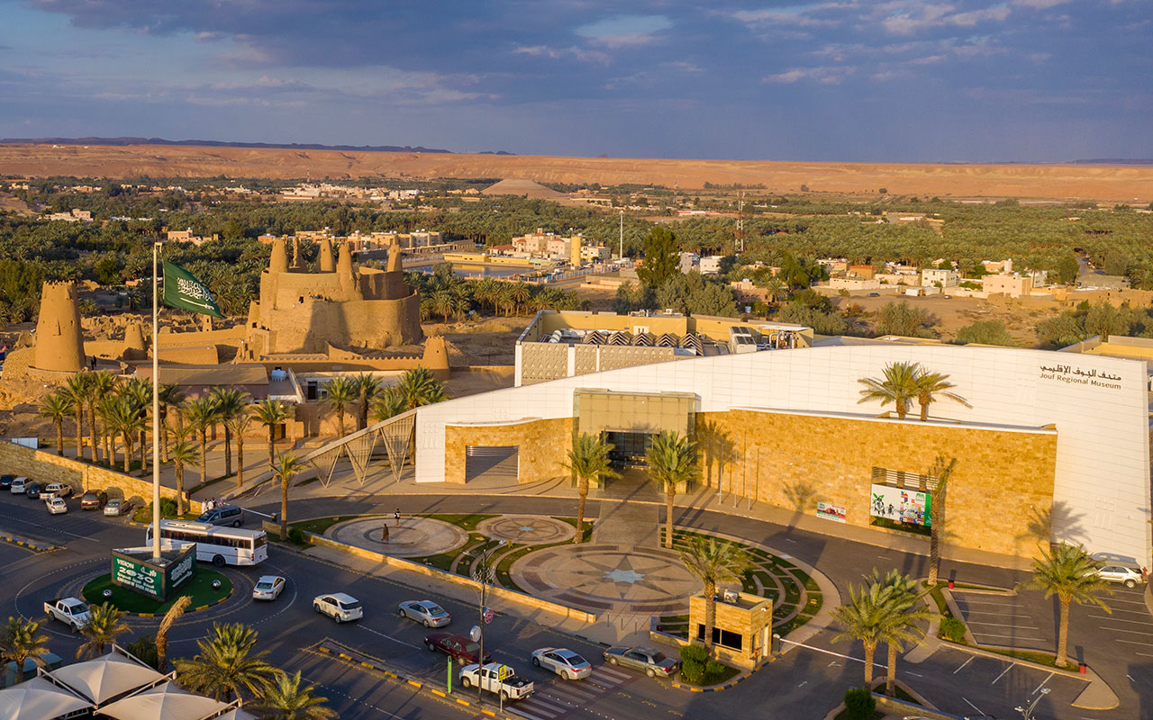
In the north of al-Jawf Province, about fifty km from the administrative capital, lies Dawmat al-Jandal Lake, one of the largest lakes in the Kingdom and the Arabian Peninsula, where national festivals and celebrations are held on its shores.
History of al-Jawf Province
Al-Jawf Province boasts a rich cultural heritage, with historical sites documenting the early history of human settlement and the early Islamic period. This is evidenced by archaeological inscriptions in Sakaka Governorate, Za'bal Castle in Sakaka, Mowaisen Castle, Marid Castle, Kaf Palace, and Omar Ibn al-Khattab Mosque. The province is also a historical station along a land route connecting the Kingdom and the Gulf countries to neighboring countries to the north.
Agriculture in al-Jawf Province
Al-Jawf Province is described as a diverse food basket and a key source of Saudi food security. Its lands host the largest modern olive farm in the Kingdom. The province contributes 16.55 percent of the Kingdom's total vegetable production and leads the provinces in the Kingdom with 3,500 agricultural projects and 12,500 farms.
Al-Bahah Province
Governorates of al-Bahah Province
Al-Bahah Province encompasses nine governorates under its administrative jurisdiction: Baljurashi, al-Mandaq, al-Makhwah, al-Aqiq, Qilwah, al-Qara, Bni Hasan, Ghamid al-Zinad, and al-Hijrah, along with forty-two centers. Al-Bahah serves as the administrative capital and the seat of the emirate, and is home to the majority of the population. The province has been governed by Prince Hussam Bin Saud Bin Abdulaziz since 2017.
Area of al-Bahah Province
Al-Bahah Province covers an area of twelve thousand km², which constitutes 0.6 percent of the Kingdom's total area. Al-Aqiq Governorate represents the largest part of its land, while Ghamid az-Zinad is the smallest governorate.
Due to the province's small size and numerous governorates, all the governorates are within a driving distance ranging from half an hour to Baljurashi to one and a half hours to Ghamid az-Zinad.
Population of al-Bahah Province
The population of al-Bahah Province is estimated at 339,174 according to the General Authority for Statistics in 2022, accounting for 1.20 percent of the Kingdom's total population. It is the least populated province in the Kingdom, with an annual population growth rate of 2.15 percent according to 2017 statistics.
Geographical features of al-Bahah Province
Al-Bahah Province can be divided into two parts: the plains represented by Tihama Plains and the mountains represented by Harrat as-Sarah Mountain Range. The province ranks fifth among the provinces with the highest mountain peaks in the Kingdom, with the highest point being Mount Uthreb in the southeast of Baljurashi, reaching an elevation of 2,447 m above sea level.
Al-Bahah Province is classified as an environmentally sustainable province. According to the City Prosperity Index and UN-Habitat, al-Bahah scores high in environmental sustainability indicators at 61.7 percent and quality of life indicators at 62.9 percent.
Economic activity in al-Bahah Province
Al-Bahah features historical buildings, villages, and traditional markets. Agriculture is the primary economic activity in the province. While livestock farming is prevalent in the plains, agricultural activity dominates the highlands, which are characterized by agricultural terraces. The mountains are covered with juniper trees, and there are fruit orchards, grain fields, and forage farms. The province is served by King Saud Bin Abdulaziz International Airport and has one public university, al-Bahah University.
Climate of al-Bahah Province
The climate of al-Bahah Province is continental and dry. The province's elevation above sea level and exposure to moist winds from the Tihama Plains contribute to moderate temperatures in the summer and lower temperatures in the winter, with frequent rainfall throughout the year.
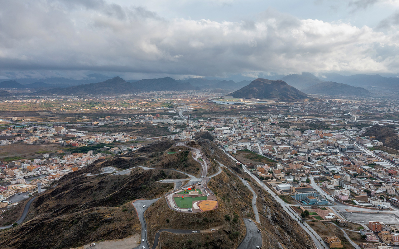
Aseer Province
Population of Aseer Province
Aseer Province is one of the provinces with a population exceeding two million, making it one of the most densely populated provinces in the Kingdom, with an average of twenty-five people per km² of its territory. The population of Aseer Province is 2,024,285 people, with Saudi citizens constituting the majority at 71.4 percent. The province covers an area of approximately 81,000 km².
Governorates of Aseer Province
Aseer Province was administratively established in 1992, and its geographical and administrative jurisdiction includes the city of Abha, which is the seat of the emirate and its administrative capital, as well as eighteen governorates. These governorates are Khamis Mushayt, Bishah, an-Namas, Mahayil, Sarat Abidah, Tathlith, Rijal Alma, Balqarn, Ahad Rufaydah, Dhahran al-Janub, al-Majaridah, Tanumah, Tarib, al-Birk, Bariq, al-Amwah, and al-Farshah. The province also includes 131 centers. The governor of the province is Prince Turki Bin Talal Bin Abdulaziz.
Geographical features of Aseer Province
Aseer Province is classified as a mountainous region, with 29 percent of the mountains of the Kingdom falling within its territory. It is a series of mountains punctuated by rugged canyons and mountain paths. Aseer got its name from its rugged terrain. However, it is fifth among the provinces of the Kingdom in terms of the longest roads, at 5,377 km long, the longest of which is the road connecting Abha to Makkah al-Mukarramah and Najran Provinces.
Harrat represents 3.75 percent of Aseer Province’s area, some of which are thirty million years old. Eight of the Kingdom's valleys pass through its territory, and the province is the lowest in the Kingdom in the proportion of sand clusters, representing just 1 percent of the total sand clusters in the Kingdom.
Heritage of Aseer Province
Aseer Province is renowned for its distinctive heritage and unique identity, which continue to be reflected in various aspects of life, including the engravings that adorn building facades, streets, household items, and utensils. This cultural richness has gained global attention, leading to the inclusion of the traditional art form known as al-Qatt al-Aseeri on UNESCO's Intangible Cultural Heritage list.
The province is home to 4,275 historical villages, including the iconic al-Muftaha Village, a symbol of Aseer Province's heritage. Al-Muftaha Village has been transformed into a cultural landmark and tourist destination, preserving the province's heritage. It houses the King Fahd Cultural Center and Talal Maddah Theater and is overseen by four entities: the Ministry of Culture, the Public Investment Fund, the Emirate of Aseer Province, and Aseer Development Authority.
To the west of the province, forty-five km from the seat of the emirate, lies the historical village of Rijal Alma in Rijal Alma Governorate. This village features eight castles perched on mountain slopes, each rising up to six stories high. The exteriors of these castles are adorned with white quartz stones, while the interiors are decorated with al-Qatt al-Aseeri art inscriptions.
Climate of Aseer Province
The climate in Aseer Province is moderate in summer and relatively cold in winter. Temperatures in August do not exceed twenty-five degrees Celsius, which is low compared to the average temperatures in other provinces of the Kingdom. Due to its location in the path of monsoon winds, Aseer experiences frequent rainfall and rainstorms, especially in its parts higher than sea level.
Tourism in Aseer Province
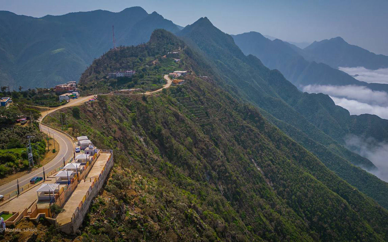
Aseer Province boasts a diverse range of terrains, including plains, coasts, and mountains. It contains twelve of the highest mountain peaks in the Kingdom, with the highest being Jabal as-Sudah west of Abha, at an elevation of 3,015 m above sea level. This elevation surpasses the highest peaks in Australia, Germany, and Greece.
The province has a coastline stretching 140 km, with three of its governorates situated along the Red Sea coast: Rijal Alma, Mahayil, and al-Birk. However, only 14.73 percent of the population lives on the coast. Unlike other tourist attractions in the Kingdom's provinces, Aseer’s varied elevations, scenic viewpoints, flowing valleys, and moderate climate throughout the year make it a popular tourist destination in the Kingdom and the Arabian Gulf.
Aseer Province is served by Abha International Airport, located in the administrative capital, Abha. The airport has a capacity of 1.1 million passengers annually, and approximately 50 percent of the province's residents can reach it by car within twenty-eight minutes. The province is also home to a public university: King Khalid University.
Development of Aseer Province
In 2021, the Crown Prince, Prime Minister, and Chairman of the Public Investment Fund, His Royal Highness Prince Mohammed Bin Salman Bin Abdulaziz, launched the Soudah Development Company in Aseer Province, with expected investments exceeding SAR11 billion. The company, fully owned by the Public Investment Fund, aims to invest in infrastructure and develop the tourism and entertainment sectors by developing the project area, which includes as-Sudah and parts of Rijal Alma Governorate.
In 2021, Aseer Development Strategy was launched under the slogan "Qimam wa Shem", peaks and values, aiming to achieve comprehensive developmental progress in the province. The strategy involves injecting SAR50 billion through various investments to fund vital projects and develop tourist attractions on Aseer’s towering peaks, making Aseer a global destination year-round. The strategy aims to transform Aseer Province into a global tourist destination, attracting over ten million visitors from within and outside the Kingdom by 2030, leveraging the province’s tourist assets.
In 2023, the launch of the "Ardara" Company was announced to develop the "Wadi Abha" project. Spanning an area of 2.5 million m², the project incorporates architectural and urban designs inspired by the heritage and history of Aseer Province. The project adheres to sustainability standards and aims to enhance the quality of life by providing more than 30 percent of the project area as open green spaces, sixteen km of waterfronts, seventeen km of sports tracks, and various cultural and community activities.
In the same year, the master plan for the development of al-Soudah and parts of Rijal Alma (al-Soudah Peaks) was launched, aiming to develop a mountainous tourist destination above the highest peak in the Kingdom, reaching an elevation of 3,015 m above sea level.
Najran Province
Najran Province location
Najran Province is located in the southwestern part of the Kingdom. It is bordered to the north and northeast by the Eastern Province, to the north by Riyadh Province, to the west by Aseer Province, and to the south by the Saudi-Yemeni border.
Governorates of Najran Province
Najran Province was administratively established in 1992. The city of Najran serves as the administrative capital and the seat of the emirate. Under its geographical and administrative jurisdiction, the province encompasses six governorates: Sharurah, the largest governorate, Hubuna, Badr al-Janub, Yadamah, Thar, and Khibash, in addition to sixty-five centers. Prince Jalawi Bin Abdulaziz Bin Musaad has been the governor since 2014.
Population of Najran Province
Najran Province ranks eleventh among the Kingdom's provinces in terms of population, with a density rate of 4.5 persons per km². According to the General Authority for Statistics in 2022, the population of Najran is 592,355. The province has an annual population growth rate of 2.26 percent according to 2017 statistics, and it covers an area of 130,000 km², accounting for 6.5 percent of the Kingdom's total area.
Economic activity in Najran Province
The economy of Najran Province relies on three main pillars: Trade, mining, and industry. In the northwest of the administrative capital, Najran, lies al-Masane al-Kobra Mining Company, and the Guyan Gold Mine in Thar Governorate, with an estimated reserve of over 8.2 million t of copper and zinc ore and four million t of gold ore. Additionally, the industrial city in Hubuna Governorate includes twenty-seven production plants with an estimated investment volume of SAR2.75 billion. The trade sector leads the province's GDP, accounting for 24.4 percent of Najran's GDP.
Climate of Najran Province
The climate in Najran varies depending on the terrain. It is generally hot in summer and cold in winter, with rainfall in the highlands. Temperatures during the year range from fourteen to thirty-seven degrees Celsius, affected by northeastern winds during winter and summer and by eastern and southeastern winds during spring.
History of Najran Province
Najran Province is one of the oldest provinces of human settlement in the Arabian Peninsula. It was home to several ancient peoples who inhabited the area thousands of years ago. This is evidenced by the rock inscriptions at Hima wells, dating back to between seven hundred and one hundred BC, and the city of al-Okhdood, with a history extending to six hundred BC. Al-Okhdood retains its historical identity, featuring castles, stone buildings, and archaeological inscriptions that tell the story of the People of the Ditch mentioned in the Holy Quran. Historically, Najran was the main transit point for all trade routes connecting the southern Arabian Peninsula with the Levant, as well as the route for spice and incense caravans.
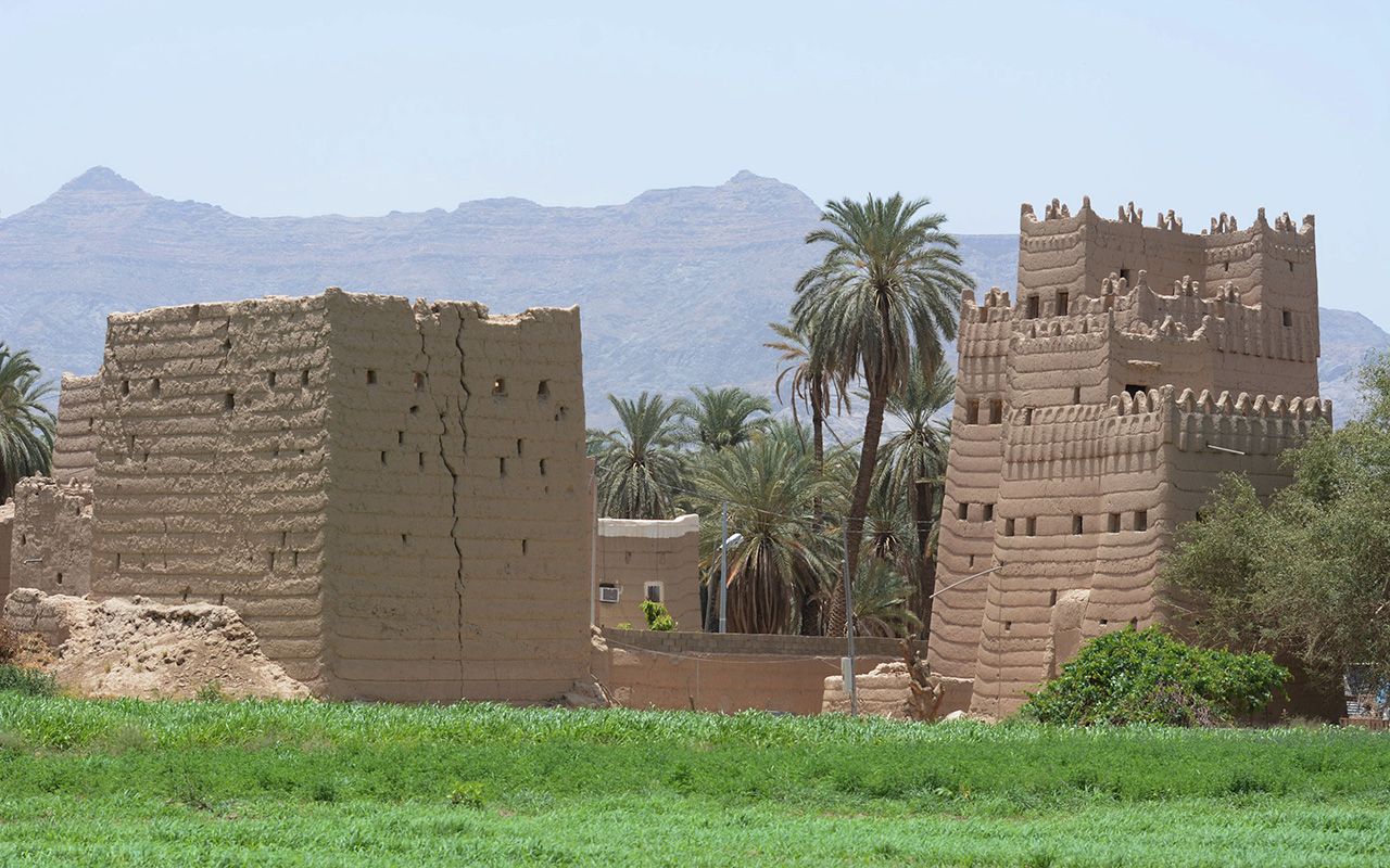
The architectural identity of Najran reflects its long history, featuring thirty-four historical villages and ancient palaces and castles, including the historical Emirate Palace founded in 1944. Additionally, the province is known for its traditional mud buildings and mud-built watchtowers.
Najran Regional Airport, located in the administrative capital Najran, serves all the governorates with distances ranging from fifty-four km to 326 km. The airport has a capacity of 1,400,000 passengers, handling approximately fifteen thousand flights annually. The province also hosts a public university, Najran University.
Najran Province, represented by the historic Aba al-Saud Neighborhood, is one of the largest markets for handicrafts in the Kingdom. The neighborhood includes nine specialized markets for handicrafts, including Mayzab, Mishrab, Khous al-Nakheel, Mihrak, pottery, soapstone, weaving, and sewing. Additionally, there is a local market specializing in selling daggers, which are an icon of the province and locally known as Janbiya.
Geographical features of Najran Province
Although the Empty Quarter Desert intertwines with the central and eastern parts of the Province, the area is considered fertile for agriculture, serving as one of the largest sources of citrus crops in the Kingdom. In fact, 40 percent of its land is designated for agricultural use, and the Najran Valley, one of the largest valleys in the Kingdom, traverses the territory, dividing the administrative capital into northern and southern parts. Natural reserves cover 9.23 percent of its territory, with the highest elevation reaching 2,224 m above sea level east of Dhahran al-Janub.
Jazan Province
Jazan Province location
Jazan Province is located in the southwestern part of the Kingdom, with the Red Sea forming its western border. It is bordered to the north and east by Aseer Province and to the south and southeast by the Saudi-Yemeni border. Its coastline marks the end of the Kingdom's Red Sea coast.
Area and population of Jazan Province
Jazan Province is the second smallest province in the Kingdom by area and the sixth largest by population. According to the 2022 Saudi Census, Jazan has a population of approximately 1,404,997 people, covering an area of thirteen thousand km², which constitutes 0.7 percent of the Kingdom's total area. Jazan records the eighth-highest growth rate among the Kingdom's provinces, with an annual growth rate of 2.23 percent according to 2017 statistics.
Governorates of Jazan Province
Jazan Province was administratively established in 1992. The city of Jazan serves as the administrative capital and the seat of the emirate. The province's geographical and administrative jurisdiction includes sixteen governorates: Sabya, Abu Arish, Samitah, al-Hurrath, Damad, ar-Rayth, Baish, Farasan, al-Dayer, Ahad al-Masarihah, al-'Idabi, al-Aridah, ad-Darb, Hurub, Fayfa, and at-Tuwal, along with forty-seven centers. The governor of the province is Prince Mohammed Bin Nasser Bin Abdulaziz.
Unlike other provinces in the Kingdom, Jazan City, the seat of the emirate, is the second most populous city after Sabya Governorate. Sabya, along with Abu Arish and Samitah, are the main population centers in the province. However, these four governorates are located close to each other, allowing residents to reach Jazan City by road within thirty to forty minutes.
Geographical features of Jazan Province
Although a significant portion of Jazan consists of highlands, 48.93 percent of the population lives on the islands and coastal plains where the largest cities and economic centers are located in the province.
Jazan is one of the most geographically diverse provinces in the Kingdom. Its western part overlooks the Red Sea, with 5.35 percent of its land comprising inhabited islands. The Farasan Islands archipelago, which includes about ninety of the two hundred islands belonging to Jazan Province, is the largest archipelago in the Red Sea and the Arabian Gulf.
The inland highlands provide ideal environments for various types of agriculture. Jabal Oairef, at an elevation of 2,632 m, is the highest point in the province and the second-highest peak in the Kingdom after the twelve peaks of Aseer Mountains.
Climate of Jazan Province
Jazan Province's climate is impacted by tropical winds, and the weather is generally very hot in summer and mild in winter, except for the mountain highlands, where temperatures are moderate and there is rainfall throughout the year.
Economic activity in Jazan Province
Due to the natural diversity and varied landscapes in Jazan Province, agriculture and fishing are major economic supports for the province. Jazan accounts for 45 percent of the Kingdom's fish production and 7.6 percent of the Kingdom's agricultural holdings. It is one of five provinces in the Kingdom classified as agricultural areas.
Jazan Province contains thirteen water dams, a relatively small number compared to other provinces in the Kingdom. However, it is among the top three provinces benefiting from dam water, providing a high storage capacity of up to 313.4 million m³ of water. Despite this, the average per capita share of drinking water is eighty-one L per day, which is below the overall average across the Kingdom's provinces.
The southwestern part of Jazan Province serves as a business hub and investment attraction area. Located on 106 km² along the Red Sea coast in the southwestern part of the Kingdom, Jazan City for Basic and Transformation Industries connects to global trade routes due to its proximity to the Horn of Africa. The city houses one of the largest Arabian oil refineries in the world and the Kingdom, processing around four hundred thousand bbl of heavy and medium Arabian oil daily.
South of Jazan Industrial City lies King Abdullah Bin Abdulaziz International Airport, located three km from the center of the administrative capital, Jazan. The airport handles approximately 2.2 million passengers through nineteen thousand domestic and international flights annually. The province also hosts a public university: Jazan University.
While the coastal part of the province serves as an economic hub, the highlands are another significant economic force in the province, particularly known for coffee cultivation in the Kingdom. Agriculture employs 20 percent of the workforce in Jazan Province, with 1.60 percent of its land dedicated to coffee farming. The province is home to two thousand coffee farms with four hundred thousand trees, yielding over one thousand t of coffee annually, producing around 785 t of pure coffee in the province.
Sources
Bureau of Experts at the Council of Ministers.
The Unified Guide for Coding Regions, Governorates, and Administrative Centers
Saudi Press Agency (SPA).Saudipedia.
The Kingdom, facts and figures. Saudi Geological Survey, 2017.