Holy Sites
The Holy Sites are three locations in Makkah al-Mukarramah: Mina, Arafat, and Muzdalifah. They are within the boundaries of the Grand Mosque, except for Arafat, which is outside of it. They are places where Muslims perform specific rituals during the Hajj season from the eighth to the thirteenth of Dhu al-Hijjah each year. Pilgrims stay there starting with Mina, then Arafat, and finally Muzdalifah
Due to their association with the performance of Hajj, Muslims have given these sites special attention since ancient times. Under Saudi rule, the kings of the Kingdom of Saudi Arabia have continuously developed these sites to accommodate the large number of pilgrims each year and to facilitate the performance of rituals at each of the three holy sites.
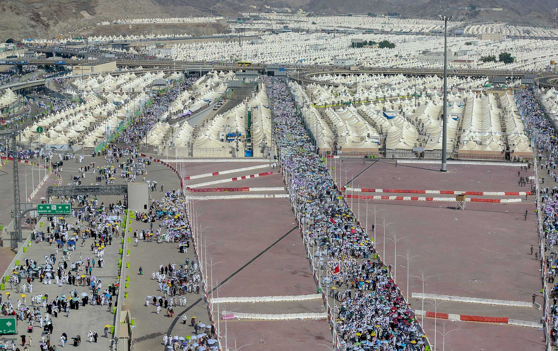
The holy sites include several landmarks of Islamic heritage, many of which remain to this day. They also feature one of the longest pedestrian paths in the world, stretching approximately twenty-five km. This path extends from Mount of Mercy (Jabal ar-Rahmah) in Arafat, passing through Muzdalifah, and reaching Mina. During the Hajj seasons, the holy sites witness one of the largest human movements in the world.
The Site of Mina
The Naming of the Site of Mina
The name Mina is pronounced with a short "i" sound, as in (Mi-na). There are various explanations for its name. Historian al-Fakihi mentioned in his book "Makkah News" that its name is due to the gathering of people there, as the Arabs used to call any place where people gather 'Mina.' Yaqut al-Hamawi states that its name comes from the blood that is shed, referring to the sacrificial animals (hady) legitimately slaughtered by a group of pilgrims. Additionally, it can mean "predetermination," as in "Manna Allah," which means "predetermined." Ibn Uyaynah states that the name comes from the word "Manaya," which means "fates".
Location and borders of the site of Mina
The site of Mina is approximately 8.4 km from the Grand Mosque. It covers an area of about 16.8 km² and is one of the holy sites within the boundaries of the Grand Mosque. The land of Mina is located in a valley surrounded by mountains to the south and north, with the Muhassir Valley bordering it from the direction of Muzdalifah.
Mina is the first of the three holy sites to which Muslims travel during the Hajj pilgrimage, starting on the eighth of Dhu al-Hijjah.
Mina is home to several landmarks. It contains the three stone pillars (Jamarat) that Muslims stone during Hajj. It also houses al-Khaif Mosque, located on the southern slope of Jabal Mina. Mina is linked to events from Islamic history as it was the site of the first and second Aqabah pledges. In the twelfth year of prophethood (621 CE), twelve men from the tribes of Aws and Khazraj pledged allegiance to the Prophet Muhammad, peace be upon him (PBUH). The second pledge, involving seventy-three men and two women, took place the following year. Additionally, one of the chapters of the Quran, Surah al-Mursalat, was revealed in Mina.
The Jamarat Facility in Mina
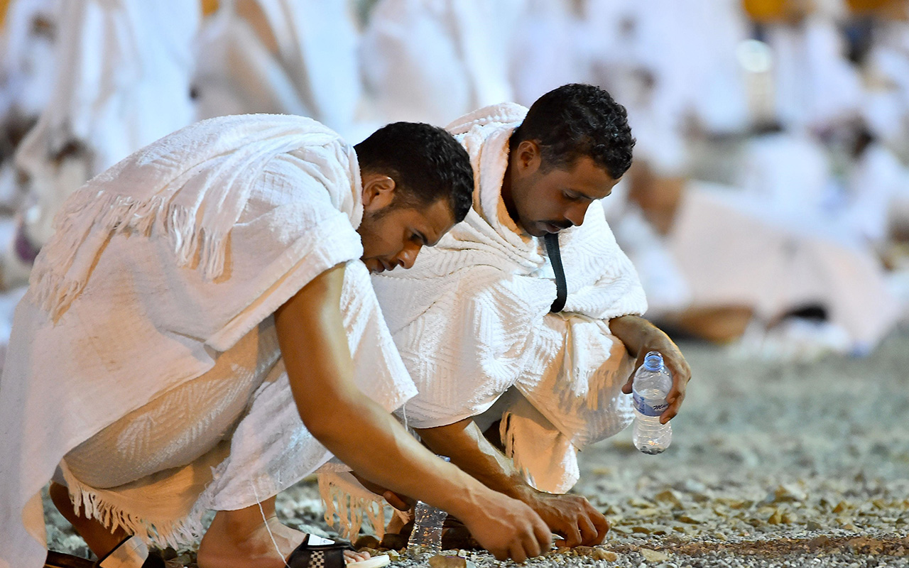
The Jamarat Facility, also known as the "Jamarat Bridge," is part of the Mina site, covering a total area of over two hundred thousand m². This area is prepared to accommodate pilgrims for the stoning ritual during Hajj, where they throw pebbles at the pillars. The facility includes the three Jamarat: the medium pillar (Jamrat al-Wusta), the small pillar (Jamrat al-Sughra), and the large pillar (Jamrat al-Aqabah). Previously, the site was a flat area with three circular basins representing the three Jamarat. Over time, under Saudi rule, it underwent several renovations and developments. Today, the Jamarat is oval-shaped, and the area has been redeveloped to construct the Jamarat facility with multiple floors (currently five stories) with foundations designed to support up to twelve floors in the future. Each floor is twelve m high, and the Jamarat Facility can accommodate approximately five hundred thousand pilgrims per hour.
The facility also includes six service buildings, each consisting of twelve floors, helicopter landing pads, and special elevators for transporting ambulances between floors. Each building contains three electrical substations and a backup generator. Additionally, the site is equipped with a cooling system that disperses a fine mist into the surrounding area, helping to cool the air and reduce the temperature to around twenty-nine°C.
In addition to developing the facility, the site has been reorganized to facilitate the movement of pilgrims with eleven entrances to the Jamarat and twelve exits on all four sides, helping to reduce crowding. Four underground tunnels for cars and buses connect the Jamarat facility to Makkah al-Mukarramah. An advanced system for counting and monitoring pilgrims includes over nine hundred cameras, along with numerous advanced safety, security, and public address systems.
Site of Arafat
Naming of Site of Arafat
The site of Arafat is also called "Arafah" and is referred to as "Arafat" in the Quran. Various explanations for its name are rooted in Islamic culture. Yaqut al-Hamawi mentioned in his book "Mu'jam al-Buldan" that it is named because people recognize or confess (i'tiraf) their sins there. In Lisan al-Arab by Ibn Manzur, it is said that it is named because people get to know (ta'aruf) each other there.
Location of the Site of Arafat
Arafat is the only holy site located outside the boundaries of the Grand Mosque. It is a flat plain surrounded by a semicircle of mountains, which includes the Mount of Mercy. It is situated on the road leading to Taif, approximately ten km from Mina, six km from Muzdalifah, and twenty km from the Grand Mosque.
Area of the Site of Arafat
The site of Arafat covers an area of thirty-three km² and can accommodate more than two million pilgrims. On the ninth of Dhu al-Hijjah, pilgrims stand at this site in accordance with the teachings of Islam. The site of Arafat is active only during the days of Hajj and does not have any buildings or residents, except for several government facilities. The Kidana Development Company has implemented a project to improve the area around the Mount of Mercy to accommodate visitors throughout the year.
Site of Muzdalifah
Naming of site of Muzdalifah
Al-Zulf in Arabic is defined as: Proximity, status, and rank. Al-Fakihi discussed the site of Muzdalifah in his book "Makkah News," dedicating a section to its boundaries and virtues. He mentioned that Muzdalifah is named because people "draw near" to it and do not stay on its land for a full day. Another name for it is "Jam'," as per the statement of al-Hafiz Ibn Hajar, who mentioned that Adam (PBUH) met Hawwa (Eve) there and drew near (Izdalaf) to her. Qatadah noted that it is named because two prayers are combined there. Some say its name comes from staying there at intervals during the night (Zilfa), or because of its proximity to Mina. Another interpretation is that it describes the gathering of people there for worship. Muzdalifah is one of the places where Muslims gather during the Hajj pilgrimage. Pilgrims are required to stay overnight in Muzdalifah on the night of the tenth of Dhu al-Hijjah (the night of Eid al-Adha), performing the Maghrib and Isha prayers together and shortening them. They spend the night there until the morning of the following day.
Location and borders of the site of Muzdalifah
Muzdalifah is located between the holy sites of Mina and Arafat, making it the third sacred site visited by Muslims during the Hajj pilgrimage after Mina and Arafat. Covering a total area of about 9.63 km², its boundaries are defined by the eastern bank of the Muhassir Valley to the west, which separates it from Mina, and by two mountains known as Mufid al-Ma'zamin to the east, with a road between them leading to Arafat. To the north, it is bordered by Mount Thabir al-Nas'ah, also known as Mount Muzdalifah.
The site has undergone expansions and development during the Saudi era. The open spaces have been prepared for overnight stays and equipped with services for pilgrims during the Hajj. These include medical and health facilities, restrooms, and guidance and security centers.
Landmarks of islamic heritage in the holy sites
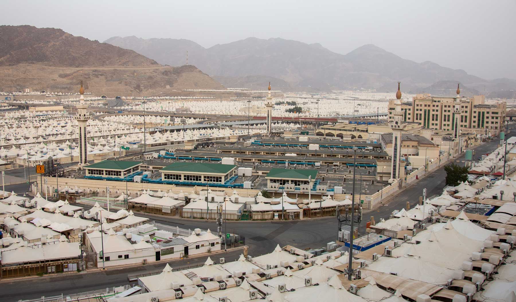
Al-Khaif Mosque
Mina includes al-Khaif Mosque, which is considered one of the landmarks of Islamic heritage. The mosque is situated on the slope of Mount al-Sabih, near the Jamarat al-Aqaba al-Sughra. The word "al-Khaif" in Arabic means the area that slopes down from a mountain and rises above the valley. The Prophet Muhammad (PBUH) delivered a sermon at this site during his Farewell Pilgrimage while he was in Mina. It is also referred to as the Mosque of the Prophets.
The mosque was built in the traditional Arab-Islamic style and has been well-maintained by Muslims since its establishment. It received its largest expansion during the Saudi era. In 1987, the mosque was expanded to its current area of approximately 23,500 m, with a capacity to accommodate about twenty-five thousand worshippers.
It is equipped with essential facilities to accommodate worshippers, including lighting, air conditioning, and restrooms. The mosque continues to receive attention and care, with the Ministry of Islamic Affairs, Dawah, and Guidance overseeing several maintenance and development projects. These efforts have included furnishing the mosque with high-quality carpets, installing thirteen central air conditioning units to provide fresh air, and around thirty fans to expel stale air. Additionally, 214 separate ceiling air conditioning units have been installed, along with electronic screens to educate and guide the pilgrims.
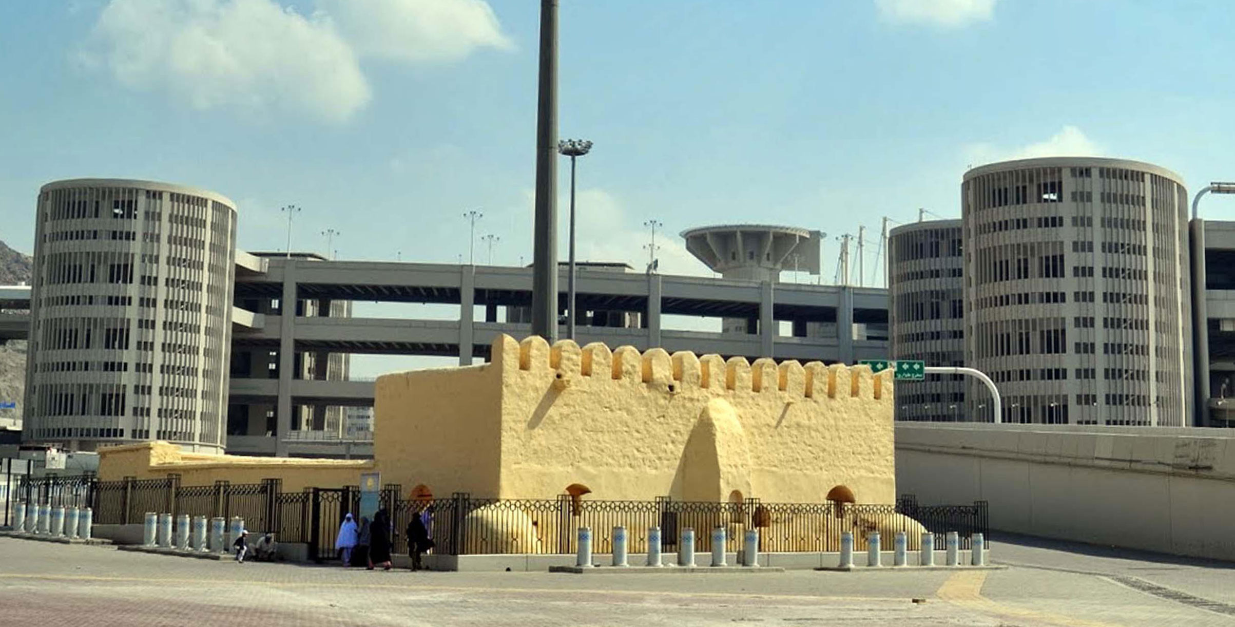
Al-Bay'ah Mosque
Al-Bay'ah Mosque, also known as "Jamarat Mosque," was constructed in the year 761 at the site of Mina. It is located about five hundred m from the Jamrat al-Aqaba. This location is historically significant as it is where the Ansar pledged allegiance to the Prophet Muhammad (PBUH). The mosque was built during the reign of Abbasid Caliph Abu Ja'far al-Mansur. Initially, it was an open-air prayer area that included a mihrab, an annex, and a courtyard. Two stones were found in the area, one of which bore the inscription, "The Commander of the Faithful, may Allah honor him, ordered the construction of this mosque," referring to the Caliph.
The mosque still retains some of its historical inscriptions to this day. It is among the mosques included in the Mohammed Bin Salman Project for Developing Historic Mosques, aimed at preserving their architectural character and maintaining them against potential effects over time. Currently, the mosque can accommodate sixty-eight worshippers.
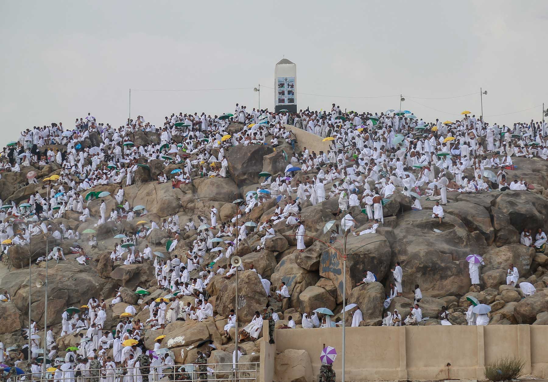
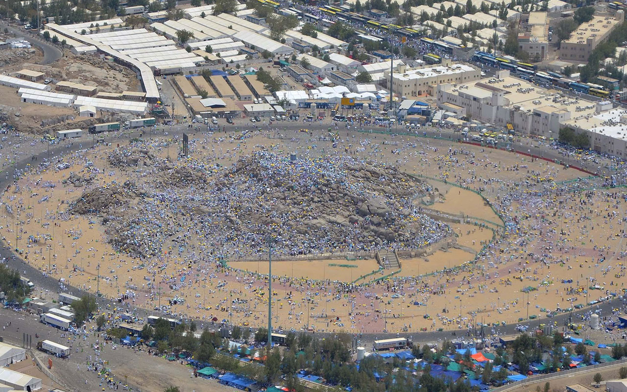
Mount of Mercy
The Mount of Mercy is located in the plain of Arafat and is known by several names, including Mount Arafat, Jabal Ilal, Jabal al-Tawbah, Jabal al-Du'a, Jabal al-Nabit, and Jabal al-Qarin. It is a small hill with a broad area and a relatively flat surface. Situated to the east of Arafat, the hill consists of solid black stones. The Mount of Mercy is approximately three hundred m long, with a circumference estimated at 640 m. At its center stands a marker that is seven m tall. The base of the mountain rises about sixty-five m above the surrounding ground.
Namirah Mosque
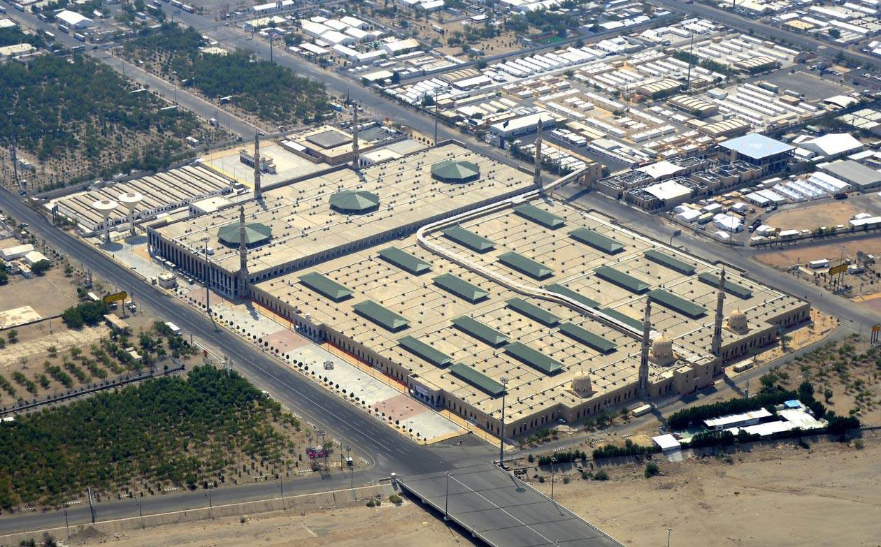
Namirah Mosque is one of the Islamic heritage landmarks in the plain of Arafat. The name "Namirah" is pronounced with an "a" sound on the first syllable and either an "i" sound or a silent second syllable. The mosque is located to the west of Arafat, with part of it situated in the Arnah Valley. It has been known by several names, including al-Khalil, Ibrahim, Arnah, and Arafat. Pilgrims gather here to perform the Zuhr and Asr prayers on the ninth day of Dhu al-Hijjah, in accordance with Islamic teachings.
The mosque received significant care and attention during the Saudi era. During the reign of the Founding King Abdulaziz Bin Abdulrahman Al Saud, it was expanded to become one of the largest mosques in the Makkah al-Mukarramah Province. Its area exceeds 110,000 m, accommodating around four hundred thousand worshippers. The mosque features six minarets, each sixty m high, three domes, and ten main entrances with a total of sixty-four doors. Additionally, there is an external broadcasting room dedicated to transmitting the sermon and the Zuhr and Asr prayers via satellite on the ninth of Dhu al-Hijjah (the Day of Arafat).
Al-Mashar al-Haram Mosque
Al-Mashar al-Haram Mosque is located in the plain of Muzdalifah, roughly midway between al-Khayf Mosque in Mina and Namirah Mosque in Arafat, at the base of a mountain called Quzah. Initially, the mosque consisted of a wall to the west indicating the direction of the Qibla. Over time, it was built on an area of about one thousand m and has been renovated several times, including a renovation during the Saudi era in 1975. Currently, the mosque is approximately ninety m long and fifty-six m wide, with a capacity to accommodate around twelve thousand worshippers. It has two minarets, each about thirty-two m high. The entrances are distributed across the eastern, northern, and southern sides.
Holy sites development
The entity responsible for developing the holy sites
Several entities have undertaken the task of developing and improving the sites of the holy places over the years. Since 2021, the Kidana Development Company, a joint-stock company owned by the Royal Commission for the City of Makkah al-Mukarramah and the Holy Sites, has been responsible for overseeing the developmental works in these holy sites. The Royal Order to establish the company was issued on February 7, 2020. The company undertakes several tasks, including increasing the capacity of the holy sites and preparing them to be a sustainable cultural center that attracts visitors throughout the year. It is involved in building and developing real estate and implementing the infrastructure of the holy sites. Additionally, the company collaborates with relevant entities to apply quality standards, ensure the safety of pilgrims, and provide suitable services for them.
The upgraded tents in Mina
The Saudi government has implemented several projects to serve pilgrims in Mina, including the construction of 160,000 upgraded tents. These tents cover about 20 percent of the site, extending over an area of 2,500,000 m, and can accommodate approximately 2.6 million male and female pilgrims.
The tents are made using modern techniques, consisting of fiberglass covered with Teflon, which resists high temperatures and fire. They also do not emit toxic gases. The tents are equipped with an automatic fire extinguishing system that activates when it senses heat. The tent sizes range between forty-eight m, sixty-four m, and ninety-six m, and they are arranged in groups surrounded by metal fences with main doors and emergency exits, connected by pathways.
The tents collectively include around fifteen thousand air conditioning units, restrooms, ablution areas, and kitchens. The design of the tents adheres to strict safety and security standards, featuring approximately thirty thousand sprinklers for firefighting and about three thousand cameras for enhanced security. Additionally, over twelve thousand speakers are installed to guide and direct pilgrims. The system includes special fire-fighting water tanks situated in tunnels atop the mountains in Mina, forming a fire-fighting network that stretches up to one hundred km. The network consists of pipes with diameters ranging from 250 mm to seven hundred mm, equipped with 740 fire hydrants and around eight hundred valves. Additionally, the pathways within the camp are paved, illuminated, and equipped with directional signs.
The development of the Jamarat Bridge
The Jamarat Bridge in Mina was constructed during the reign of King Faisal Bin Abdulaziz Al Saud in 1974. It has undergone several development works over the years, including an expansion to about forty m wide, with two approaches from the east and west and two ramps adjacent to the Jamarat al-Aqaba from the upper level, both north and south. Further development works followed in 1978, which included the construction of concrete ramps (approaches and exits) for the second level of the Jamarat on both sides of the bridge, opposite the location of the minor Jamarat.
In 1982, an expansion was carried out, increasing the width by about twenty m and the length by 120 m on the northern side. This was followed by another expansion in 1987, which expanded the width to eighty m and increased the length to about 520 m. Additionally, the ascent ramp was widened to about forty m with a length of three hundred m. Five towers were constructed to provide services to pilgrims on both sides of the bridge. Signage, lighting, and ventilation were also installed, bringing the total area to 57,600 m at that time.
In 1995, the Jamarat Bridge entered a different phase of development and organization. Adjustments were made over various periods to combine its appearance with facilitating the movement of pilgrims. Similar modifications and arrangements followed in 2005, including changes to the bridge's structure and altering the shape of the basins to become oval instead of circular. Additionally, the markers were adjusted, and emergency exits were created at the site of Jamrat al-Aqaba. Informational signs and screens connected to the pilgrims' camps were also installed, providing awareness information on how to behave in case of crowding.
With the increase in the number of pilgrims in the following year, 2006, it was decided to replace the bridge with another multi-story structure to accommodate larger numbers and contribute to the smooth movement and safety of the pilgrims. In 2011, the Ministry of Municipalities and Housing developed it as part of the Jamarat facility development project, using a cantilever suspension system. The project won several international awards, including three in the field of construction.
The project was implemented to provide greater capacity at the Jamarat site, accommodating over six million pilgrims and allowing them to perform the stoning ritual in a safe and secure environment. It also helped reduce crowding by creating multiple, spaced-out entrances to the bridge, facilitating the flow of pilgrims through the expansion and modification of the basins, constructing service towers, ensuring evacuation methods, improving cleanliness, and providing necessary operational supplies.
It also included the expansion of the surrounding areas, particularly the southern and northern parts, and at the site of the Jamrat al-Kubra to facilitate the movement of pilgrims and accommodate the new bridge with its attachments. The project involved the construction of stations west of the Jamarat site for boarding and alighting pilgrims. The square was reorganized after its expansion, especially in the eastern part, to achieve a balanced distribution of the pilgrims.
The newly renovated Jamarat structure consists of multiple levels. The lower level is designated for evacuation, connected to the upper levels by elevators. This level is also used to collect pebbles and waste from the other levels of the bridge and transport them outside the Jamarat site. The ground floor allows pilgrims to perform the stoning ritual and can be accessed from multiple directions. The first floor can be accessed from the Mina side via two ramps located in front of the southern and northern pedestrian paths, with visibility to the ground floor. The second floor is accessible via two ramps, one to the north and one to the south. The third floor can be reached from Mina through a ramp starting from King Fahd Road. Pilgrims can access the fourth floor from the south through a ramp on King Abdulaziz Street.
The facility includes two service towers that were built as part of the project, featuring helipads and offices for various entities involved in the Hajj. The project also implemented a ventilation system for the lower floor and desert air conditioning units on the first, second, and third floors. The fourth floor utilizes water sprayers for air cooling. Additionally, a system for monitoring and controlling the air cooling systems was established.
Additionally, a lighting system was implemented for all floors, service towers, ramps, and escalator buildings, equipped with backup generators and transformers. A sound and surveillance system was also installed, featuring cameras that cover all parts of the facility. Furthermore, guidance signs were added at the entrances, on the bridge, and along the ramps. Gates were installed at the escalator buildings and ramp entrances to help control the entry of pilgrims.
In the Hajj season of 2015, the Jamarat Bridge underwent an expansion that included increasing the area of the western plaza by up to forty thousand mon the northern side. This expansion aimed to enhance its capacity and make the plaza an exit leading to the city of Makkah al-Mukarramah. At that time, Hajj Street was reorganized and its elevation was lowered. The road connecting to Prince Majed Street was also restructured, including the intersection with al-Masjid al-Haram Street to align with the new expansion. Additionally, a mountainous mass was removed to facilitate these changes. The project also included the construction of a road connecting the Western Shuaib with the third level of the Jamarat. Additionally, pedestrian tunnels were expanded and their routes were modified to pass through King Khalid Road.
The initiative to address visual pollution in the holy sites
Kidana Development Company launched an initiative to improve visual pollution in the holy sites. This initiative involves removing uncivilized elements, raising awareness about environmental preservation, educating workers in the holy sites about these issues, and protecting public facilities. This initiative supports one of the Saudi Vision 2030 programs, "Quality of Life," and involves sectors operating in the holy sites. It targets the reduction of visual pollution by removing graffiti and illegal commercial signs, and trimming trees. Additionally, the initiative utilizes vacant lands for advertising spaces and implements projects to improve traffic flow on main roads.
As part of its initiative, the company worked on improving the areas adjacent to Mount of Mercy in Arafat, covering an area of about two hundred thousand m. This aimed to enhance the facilities and services provided to visitors throughout the year, meeting contemporary requirements The initiative included constructing parking areas for buses and visitor vehicles, building new restrooms while upgrading existing ones, and enhancing the lighting around the mountain and its vicinity. It also improved climate control pillars and water fountains and created green spaces, seating areas, and designated walking paths. Additionally, the initiative involved setting up sales points for restaurants and cafes, establishing an informational system, constructing observation towers to enhance security, and providing platforms for television channels, as well as sites for government entities serving visitors and pilgrims.

Services provided in the holy sites during the Hajj season
The Mashaer train
The Saudi Railway Company 'SAR' operates the Mashaer train during the Hajj season to facilitate the transportation of pilgrims, adhering to quality and safety standards. The train operates from the seventh to the thirteenth of Dhu al-Hijjah, conducting over 2,200 trips. Seventeen trains run between nine stations across the three holy sites: Mina, Arafat, and Muzdalifah. The first journey of the train was launched in 2010, with a route spanning twenty km, connecting the southeast of Arafat to the southwest of Mina.
The train is equipped to allow pilgrims access via elevators, ramps, escalators, and regular stairs. Electronic gates separate the train from loading and waiting areas and utilize sensor technology to recognize ticket holders. Pilgrim flow is managed through specific pathways leading to waiting areas that can accommodate more than three thousand pilgrims.
The project includes seventeen trains, consisting of 204 carriages with a length of three hundred m each. Each carriage can accommodate about three hundred pilgrims, in addition to a front and a rear carriage. The train operates under an automated control system managed by a central operation and monitoring center. During its journey, it stops at three stations for each holy site, starting with Arafat, then Muzdalifah, and finally in Mina. It stops at the first station, then the second station, and finally the third station, which reaches the fourth floor of the Jamarat facility. From the Jamarat station, the train returns, passing through Mina, Muzdalifah, and then Arafat, traveling at speeds ranging from eighty km/h to 120 km/h.
The project received the global FIDIC (International Federation of Consulting Engineers) award, as it was selected from among twenty-four projects worldwide over the last one hundred years for its contribution to easing congestion and preserving the environment from car emissions. Additionally, the Mashaer Railway (Southern Line) located at the Jamarat facility won the Franz Edelman Award in the United States for the best-applied research and operational studies.
Digital efforts in supporting the holy sites
The Saudi Data and Artificial Intelligence Authority (SDAIA) is strengthening its role in serving pilgrims through a strategic partnership with the Ministry of Interior. SDAIA is equipping the gateways to the holy sites with digital infrastructure to secure the movement of pilgrims between the Grand Mosque in Makkah al-Mukarramah and the holy sites for the Hajj rituals in 2023.
SDAIA supports government, security, service, and health entities operating during the Hajj, serving as the national enabler for all matters related to artificial intelligence and data. It facilitates the movement and transportation of pilgrims between the holy sites through artificial intelligence algorithms, offering around twenty services to aid the pilgrims.
The platform 'Baseer' represents one of SDAIA's services, offering an algorithm that counts the number of pilgrims to help manage movement in the holy sites and prevent overcrowding that could lead to stampedes. Additionally, the platform assists relevant entities in taking appropriate measures when congestion occurs that could disrupt movement or cause high density at any of the holy sites. It addresses these issues by directing pilgrims to less crowded areas. This technology also aids in locating missing individuals among large crowds. SDAIA continually develops its operations annually to enhance the technological services provided based on insights gained from each Hajj season.
The municipality of the Holy Capital supports the holy sites through various digital services. In the 2023 Hajj season, it introduced a suite of applications to operate service centers in the holy sites, numbering around twenty-eight centers. These centers contribute to institutional performance development and improvement by reengineering processes and procedures and enabling organizational units to digitize their operations. Additionally, they monitor field observations and elevate them in various formats (video, audio, text), linking all images and clips to geographical locations and generating reports.
Several applications have been activated to serve the pilgrims, including one that enables the issuance of temporary permits for kitchen owners. Applicants submit their requests through the system, which automatically forwards them to the municipality for verification. This facilitates the operations of kitchen and restaurant owners by ensuring they meet specific requirements, allowing them to provide organized services that meet the needs during the Hajj season. Additionally, the scheduling of slaughtering is managed electronically.
The municipality adopted an electronic system for managing cleaning equipment to provide a safe and healthy environment for pilgrims in the holy sites. Utilizing modern technologies, an operations room was established for electronic monitoring, enabling the tracking of equipment and machinery movements and the emptying of containers.
These smart solutions enhance the pilgrim's experience and streamline procedures during the Hajj season, supporting the realization of Saudi Vision 2030's goal to develop government services through modern technologies.
Sources
Royal Commission for Makkah City and Holy Sites.
Ministry of Islamic Affairs, Dawah, and Guidance
King Abdulaziz Foundation for Research and Archives (Darah).
Saudi Press Agency.
The Ministry of Hajj and Umrah.
Al Ekhbariya Channel.