Hegra
Hegra or Hijr is a World Heritage Site and a Saudi touristic and historic monument. It is located in AlUla governorate, affiliated with Madinah, northwest of the Kingdom of Saudi Arabia. Hegra, which was known for a long time as Mada’in Salih, consists of ruins that have combined various historical eras, including Nabataean, Lihyanite, and Islamic. Its most famous landmarks are the historical tombs carved on the facades of sandstone rocks.
Hegra was one of the first Saudi sites to be registered on UNESCO's list since it was added in 2008.
Hegra consists of an open archaeological museum amidst the sands of Wadi Al-Qura. Its 116 tombs have been categorized into groups according to their proximity and coherence in terms of inscriptions and architecture. Hegra was included in the Custodian of the Two Holy Mosques Cultural Heritage Program, and excavations, development, and restoration of its monuments are still ongoing.
Historic importance of Hegra site
Geographic location of Hegra
Hegra is situated within AlUla governorate, in the northwest of Saudi Arabia, and it is administratively affiliated with Madinah. It is located twenty-two km from the center of AlUla governorate and is one and a half hours away by plane from the capital city, Riyadh. It is positioned halfway between Tabuk to the north, at a distance of about 270 km from the city, and Madinah to the south, roughly 355 km away. Hegra is also approximately 353 km distant from the Red Sea project.
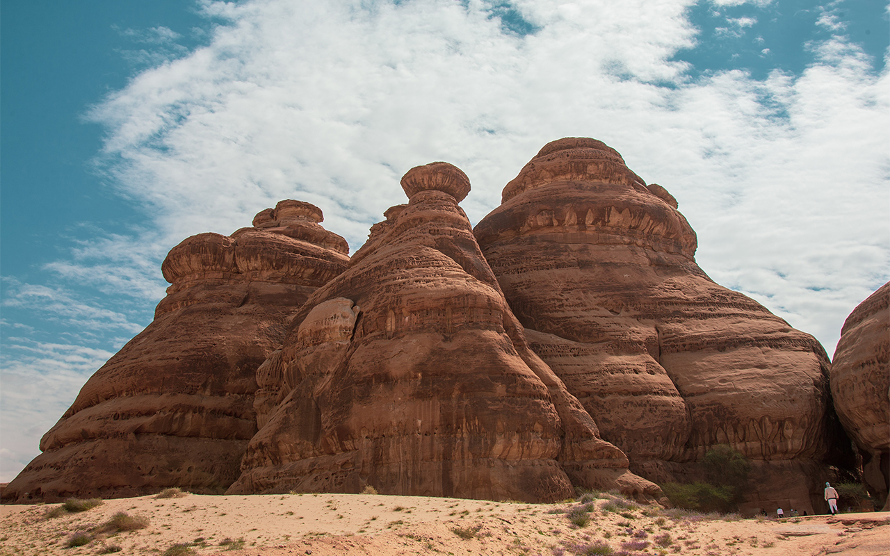
Hegra consists of an open archaeological museum amidst the sands of Wadi Al-Qura, covering an area of over thirteen km, from which the high mountains are visible with their meticulously carved facades. Despite its famous monuments connected to the Nabataens, the monuments and inscriptions dating back to the Kingdoms of Lihyan and Dadan, which settled in the valley before the Nabataens, are still evident in about fifty inscriptions, drawings, and texts.
Historic importance of Hegra
Hegra was a meeting point for commercial caravans traveling the Incense trade route all the way from Greece, Rome, North Africa, and the south of the Arabian Peninsula. It stands as the second-largest testament to the Nabataean civilization, surpassed only by the ancient city of Petra in Jordan. Hegra hosted ancient Arabic kingdoms and tribes, such as the Minaeans, Thamudis, Lihyanis, and eventually the Nabataeans. During the rule of the Nabataeans, spanning approximately seven hundred years, Hegra thrived and achieved a prominent economic status, becoming the trade capital of their kingdom.
The site carries a religious significance because it was inhabited by the Thamudis, who were referred to in the Holy Quran as The Thamud: 'And Thamud who carved 'their homes into' the rocks in the 'Stone' Valley' (Al-Fajr: 9), and residents of the Stone: 'Indeed, the residents of the Stone Valley also denied the messengers' (Al-Hijr: 80). The period during which the Tamudis lived in Hegra is estimated at 3000 BC. Islamic scriptures indicate that they carved the mountains and made them their homes, and that Allah sent them a prophet called Saleh.
Hegra in the Arab Heritage
On the other hand, Arab literature glorifies the valley (Wadi Al-Qura) where Hegra is located, which is the origin of a famous love story between the Arab poet Jamil Ibn Ma'mar Al-Udhri and Buthaina Bint Haba' Bin Rabiaa.
If my poems were to remain in Wadi Al-Qura for one night, my heart would rejoice
If I were to meet with Buthaina just once, we would fly with our love to the skies
Hegra on the World Heritage List
Hegra (Mada’in Salih) site was inscribed on the UNESCO list in July 2008. Studying the registration of Hegra on the list commenced in 2001 when a ministerial committee was formed to conduct the study. This was followed by the issuance of an approval decision on August 13, 2006, for the registration of three sites: Hegra, Historic Diriyah, and Historic Jeddah. Saudi Arabia then submitted the preliminary list of these three sites to the UNESCO World Heritage Center. The initial acceptance of these sites took place on October 17, 2006.
Three UNESCO experts visited Hegra site and reviewed the nomination file. They also presented the nomination file for Hegra site, submitted by Saudi Arabia, which includes a holistic plan for site management, protection, and restoration. This marked Saudi Arabia's first-ever nomination for inclusion on the World Heritage List, submitted on January 30, 2007. Following an on-site visit and nomination file review by an expert from the International Council on Monuments and Sites (ICOMOS), the committee submitted Hegra site's protection and management plan to the World Heritage Center. Additionally, an exhibition showcasing the monuments in Hegra was hosted at UNESCO headquarters in Paris as part of the efforts to have Mada’in Salih inscribed on the World Heritage List in September 2007.
Eras of of human settlement in Hegra
Era of Middle Arab Kingdoms
The history of the first human settlement in Hegra dates back to the third millennium BC when the Kingdom of Lahyan inhabited the area, as indicated by scientific studies, stone tools, rubble tombs, and a number of rock inscriptions found onsite. In fact, approximately thirty-six rock inscriptions were discovered on Jabal Ithlib, dating back to the Dedanite and Lihyanite periods. These inscriptions form a historical record of the Kingdom of Lihyan, preserving the names of its kings, its civilization, and the cultural and religious conditions of society. This information has helped in understanding the chronology of rule in the region and the stages of development that writing underwent in the area.
Era of Late Arab Kingdoms
The true and significant prosperity of Hegra site was realized during the era of the Nabataeans, who were Arab tribes that established a kingdom lasting for three centuries. Its boundaries extended from Damascus in the north to Hegra and Tayma in the south, and from Duma in the east to the Red Sea in the west. Subsequently, they were displaced from their first capital, Petra, and relocated to Hegra, making it their second capital and headquarters. During the period spanning from the first century BC to the second century AD, Hegra experienced a flourishing period under their rule, becoming a prominent center in the region. In fact, Nabataean inscriptions indicate that it held second place in importance, following Petra, which served as the first capital of the Nabataeans.
Roman presence in Hegra
Hegra gained interest in subsequent eras with the presence of Romans in the Arabian Peninsula following the fall of the Nabataean state in the first century AD. With the advent of Islam, Hegra assumed historical importance as a stop along the Levantine Hajj route. Roman presence in the region persisted until around the fourth century AD.
Archaeological monuments in Hegra
Hegra's 131 tombs have been categorized into groups according to their proximity and coherence in terms of inscriptions and architecture. The Nabataeans used tombs and rock cavities to bury the deceased. The external inscriptions and texts, as well as the carving styles, depict Nabataen religious symbols. Moreover, the tombs and their lengths provide insights into the social and economic status of their owners. A tomb's location and distance from other tombs and the inhabited village serve as indicators of the owners' importance and social status.
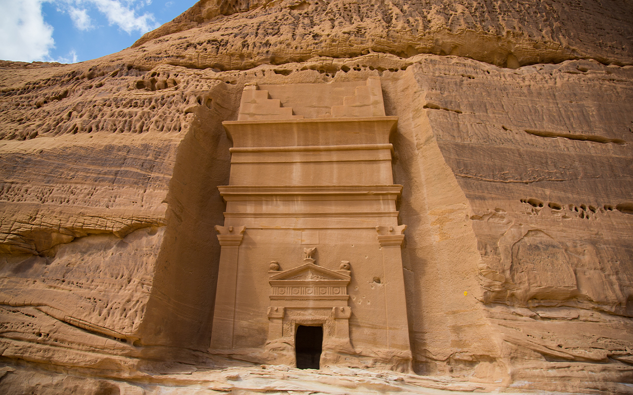
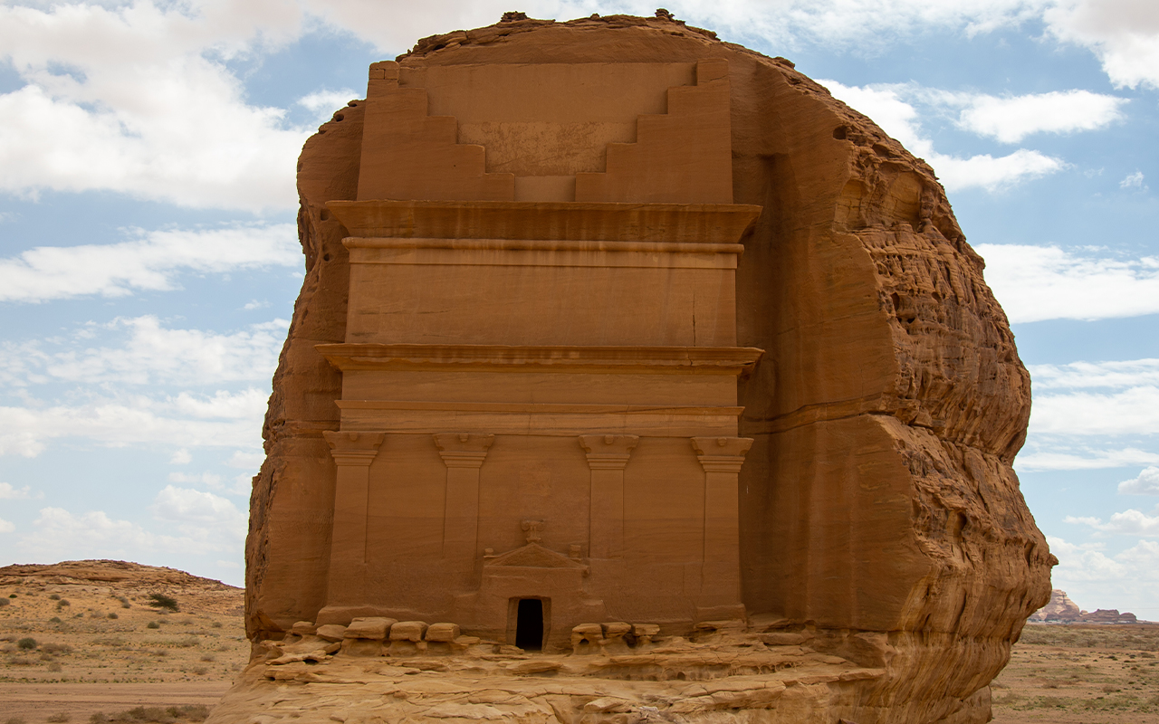
Qasr Al-Farid
Qasr Al-Farid, the most renowned landmark within Hegra site, stands distinct from the other tomb groups. It is the tomb of Lahyan Ibn Koza, carved into a single rock block at a height of approximately twenty-two m. It boasts a unique facade with four columns, a departure from all other two-columned tombs. Situated in the southeast of Hegra, Qasr Al-Farid distinguishes itself from its counterparts with its substantial size, which earned it the name (literally translates into the Lonely Castle), as well as distinctive architectural elements. Despite its unfinished state, Qasr Al-Farid provides insights into the stages and techniques employed by the Nabataeans when carving tomb facades. Through Qasr Al-Farid, the method of planning for the tomb’s facade even before its construction was evident. The construction process started from the summit of the rocky mass and progressed downward. It shows that the facade can be divided into three distinct sections. The upper portion features five steps, similar to other tombs. The second section includes an Egyptian cornice at its base, followed by another parallel cornice. The third section stands out with its unique artistic elements, including four columns adorned with Nabataean capitals. Above the entrance, an incomplete triangular facade is visible, topped with a broken-headed eagle. Adjacent to the entrance, two unfinished urns and partially constructed columns can be observed.
Jabal Ithlib tombs
Jabal Ithlib tombs are located on the eastern side of Hegra. Jabal Ithlib is the highest mountain in the site, overlooking a wide area of its surroundings. It is likely that it served as a surveillance center along the trade route in ancient times, given the abundance of Lihyanite inscriptions discovered on it and that it provides insight into the northern end of Wadi AlUla. Additionally, it is probable that the mountain hosted a religious center subsequently used by the Nabataeans. Jabal Ithlib boasts a plethora of ancient Arabic inscriptions from Lihyanite, Thamudic, Nabataean, and Islamic periods. The mount features architectural elements, they are: The Diwan, a large hall carved into the northern part of the mountain. Flanking its facade are two columns; inside, it consists of three benches. The Diwan was believed to be used for meetings as a senate or for religious ceremonies.
Jabal Ithlib also contains mosques and archaeological temples. Inscriptions have shown the allocation of sacred places for worship, referred to as mosques. Additionally, temples were established at the mountain's summit, with carved stairs leading to them. Examples include the Qasr Al-Ajouz Temple and niches that are scattered in front of Diwan Square, along Al-Siq corridor, and on the side of the valley. At the mountain's peak, there are also water tanks and canals. The Nabataeans excelled at excavating wells and underground channels to connect water sources. They constructed tanks within the rocks and directed rainwater into them through channels carved into the mountain. Approximately 130 wells have been discovered at the site.
Qasr Al-Bint tombs
It is a cluster of contiguous tombs that cover the majority of Jabal Al-Banat. Located to the northeast of the residential area and to the west of Jabal Ithlib, it comprises two rock formations. The first one houses thirty-one tombs, while the smaller formation contains only two tombs. Qasr Al-Bint cluster exhibits variations in both size and decorative elements. Some tombs feature names and symbols, while others include statues of both humans and animals.
Al-Sanea Tomb
Visible to those entering Hegra from the southern gate, there is a cluster of tombs situated amidst two rocky formations, through which the railway passes. The western formation contains a tomb with a fully intact facade, constructed by Malkyun Al-Arraf for his father, Hunayn Hefastyon, who served as a chief and captain. This tomb is dated April of the seventeenth year of King Aretas IV's reign. On the other hand, the eastern formation consists of six tombs with incomplete facades, which appear to have been affected by erosion factors. These facades lack any artistic work.
Jabal Al-Ahmar
It consists of two rocky formations known as Jabal Al-Ahmar, located to the south of the residential area and to the north of Al-Farid tombs. The first formation includes eighteen tombs with various facades, likely among the oldest tombs. Some of these tombs contain inscriptions with the names of their owners. The second formation is smaller in size and contains only one tomb.
Al-Khuraymat
Al-Khuraymat is situated on the western side of the residential area. It comprises seven contiguous rock blocks containing fifty-three tombs. Al-Khuraymat tombs are distinctive in that they incorporate most artistic elements on their facades. They are regarded as among Hegra’s most diverse tombs in terms of inscriptions. Additionally, they stand out due to the absence of certain features found on the facades of some of them, such as Nabataean columns and capitals, the triangular facade, and prominent cornices. Some of these tombs feature a series of terraced balconies on their facades. Their gates lack columns, and it appears that natural factors have caused some of the tombs to lose parts of their facades.
Architectural elements of Hegra tombs
Types of tombs
The types of tombs at Hegra sites differ in terms of size, formation, and construction method. According to archaeologists, they are classified into five groups. The first group consists of simple graves that are smaller and shorter than the other graves. They feature one or two parallel rows of small, decorated balconies at the bottom adorned with star or flower decorations. The second group comprises tombs that do not use balconies but instead feature two large, opposing rows of stairs, each with four or five steps.
The third group is distinguished by its precision and mastery of carving. Each tomb in this group is surmounted by a half balcony with two facing terraces and two parallel Egyptian cornices. It includes four columns of varying heights, with entrances adorned by triangular facades decorated with a frieze featuring star and flower shapes. At the top of these graves, inscriptions of an urn, an eagle, and a mythical animal can be found, but they lack religious symbols such as human faces and snakes. The fourth group consists of graves with two rectangular columns topped by simple beveled capitals. At the top, there are two parallel arches with a band of oval shapes in the middle. Inside the arches, a six-pointed star is featured, accompanied by three urns. The fifth group comprises tombs with plain facades devoid of any decoration. These tombs have rectangular entrances leading to the burial chamber or square openings high above the ground. It is likely that these are individual tombs, as mentioned in one of them.
Decorative elements
The decorative elements in Hegra tombs are concentrated on the main facades, including the triangular and arched facades, as well as the cornice - a protruding part of the facade that either maintains a flat shape or graduates downwards. This cornice is intricately carved along the entire width of the tomb's facade. There is also the Egyptian cornice, which extends from the top and gracefully curves downwards. Another noteworthy feature is the frieze, a prominent strip that may consist of one, two, or even three protrusions, with the lower one being less prominent. Some friezes are adorned with decorative inscriptions. The Nabataean capital is the element that tops columns, while columns, rectangular in shape on both sides of the facade, are the main element of most facades. Both the facades and entrances maintain a consistent rectangular shape, with some lacking any decorative embellishments. Human decorative elements take the form of faces and masks on tomb facades, while animal decorative elements hold special importance in Nabataean culture due to their significance in religious beliefs and the symbolism of power they represent. These animal elements include the lion, eagle, snake, and the mythical creature, the Sphinx. Additionally, plant-themed decorative elements are present, with the star flower being the most notable. Moreover, the decorative elements encompass carving urns, which hold religious symbolism related to water as a source of life.
Hegra urban heritage
Hegra Islamic castle
It is situated on the northern side of Hegra along the Levantine Hajj Road. This two-story castle was constructed in the style of Ottoman castles and was built by the governor of Damascus at the time, As’ad Pasha Al-Azm. The castle is square in shape with walls standing at a height of 8.35 m. Its entrance is crowned by a watchtower, and it houses two wells - the first located inside the castle's courtyard, and the second in the east of the castle. Additionally, the castle's courtyard features four additional watchtowers and two prayer rooms, one on the ground floor and the other on the upper floor. Surrounding the courtyard, there are several rooms, in addition to those on the upper floor.
Hejaz Railway stations
These are the remnants of the Hejaz Railway, established during the Ottoman era. It comprises seventy-five primary and subsidiary stations. Hegra station was inaugurated in 1907 and consists of sixteen buildings with various functions, including a rest house for employees, housing for staff members, guard towers, lavatories, furniture storage facilities, maintenance workshops, and a water tank.
Tourism in Hegra
The development of Hegra
Excavation, development, construction, and ruin restoration and preservation never stop at Hegra. The site was added to The Custodian of the Two Holy Mosques Cultural Heritage Program. RCU was established to preserve the governorate's historical and archeological sites through a number of programs and initiatives, in addition to activating and preparing these archeological sites to welcome visitors from all around the world. Furthermore, RCU seeks to engage the people in the preservation of monuments, exploratory surveys, training and employment opportunities, and a scholarship program for both female and male students.
RCU preserved the Sharaan Nature Reserve in order to protect the most important natural and ecological habitats and their biodiversity.
Journey Through Time Masterplan
To achieve Saudi Vision 2030 targets, His Royal Highness Crown Prince Mohammed bin Salman, prime minister and chairman of the board of the Royal Commission for AlUla (RCU), launched the design vision for the Journey Through Time Masterplan in 2021. The latter is a major milestone in AlUla's development program, which seeks to transform the city into an international pioneering destination for art, heritage, culture, and nature.
The masterplan relied on intensive scientific studies about the human patterns and the environmental and geological development in AlUla. A team of Saudi and international experts supervised the project for three years. The Journey Through Time masterplan consists of three main stages, with the first one expected to be completed by the end of 2023. The masterplan constitutes a part of a comprehensive development program for AlUla, overseen by RCU. When completed in 2035, the development strategy aims to contribute SAR120 billion to Saudi Arabia's GDP and generate 38,000 new job opportunities.
The Journey Through Time masterplan provides a historical map of civilizations that have settled in AlUla oases for more than 7,000 years of human history. Five districts extending over 20 km from the center of AlUla will serve as waypoints on the Journey Through Time masterplan, starting from the Old Town in the south, passing through the center of Dadan oasis, Jabal Ikmah's oasis, and the Nabataean oasis, and culminating at Hegra Historical City in the north. As AlUla serves as a crossroad and a connection center for the northwestern Arabian Peninsula, AlUla's tourist tram line will connect AlUla International Airport to the five districts.
Within these districts, fifteen new cultural facilities will be established, including museums, exhibitions, and tourist attractions. These facilities will serve as landmarks for each district. Moreover, over five thousand accommodation and living rooms will be constructed, and every district will offer its own tailored blend of living and hospitability options, ranging from hotels and eco-tourism resorts to luxury lodges and canyon farms carved into the sandstone rocks.
Kingdoms Institute in AlUla
In 2021, His Royal Highness Crown Prince Mohammed Bin Salman launched the Kingdoms Institute, an international center for the study of civilizations that settled in the northwest of the Arabian Peninsula for 7,000 years of human history. These ancient Arab kingdoms include Dadan, Lihyan, and the Nabataeans in the historical city of Hegra. The institute stands as the most prominent project within the Journey Through Time masterplan.
The institute aims to preserve and protect the legacy and heritage of AlUla, as it is a historic crossroad linking three continents. The institute, within its scope of work, involves archaeological excavation missions that include Saudi and international experts of various specializations working all around AlUla.
Hegra After Dark program
It is a tourism program within the Ancient Kingdoms Festival organized by RCU. This program offers an evening experience to its visitors in three stages, enabling them to explore the archaeological evidence of the Nabataean civilization in Hegra. During the night, candles are placed across Hegra tombs and special sessions are prepared, accompanied by scenes and traditional melodies played on old instruments, along with specialized flavors from the region's heritage. The second stage involves a ride on horse-drawn chariots under the stars. The third stage is dedicated to walking along the rock art trail, which guides visitors through rock carvings and inscriptions made by travelers and the people of AlUla thousands of years ago.
Hegra in the Metaverse
RCU has established a digital presence for the archaeological city of Hegra within the virtual world. This allows visitors from all corners of the globe to explore it. Built on the 3D Metaverse platform Decentraland, the new online destination is the inaugural UNESCO monument to appear within the virtual realm. RCU continues to explore new methods to engage with visitors in innovative and inspiring ways.
Created using cutting-edge and immersive technology to reproduce Hegra in the digital space, the virtual platform for the city of Hegra allows interested individuals to embark on trips to explore AlUla's most famous landmarks in the Metaverse in a virtual environment that simulates being on the ground. The Metaverse represents the ultimate destination as part of RCU’s comprehensive regeneration of AlUla that will regenerate the governorate into the world's largest living museum – now accessible in both the real and virtual worlds.
The platform allows visitors to navigate the place using their avatar character and explore the natural and cultural environment. Information portals have been designed to guide visitors to various sites that showcase AlUla's rich history and civilization, expanding awareness of its 200,000 years of human history. The metaverse project is an initiative by RCU aimed at reimagining the region's rich heritage and providing access to it for those interested, in order to enhance the knowledge of twenty-first-century visitors about the governorate by allowing them to virtually explore it before making the journey in person.
Reconstruction of the facial structure of a woman from the Nabataean era
As part of the efforts of RCU to highlight the historical heritage of the region, archaeological experts have successfully completed a digital reconstruction of the facial structure of a woman known as Hinat, whose remains were previously found in Hegra dating back to the Nabataean era. Archaeologists believe that she passed away in the first century BC and was buried in a tomb in Hegra. Her body remained there for two thousand years until its discovery in 2008. Historical sources and studies confirm that Hinat enjoyed a high social status in Nabataean society and possessed significant wealth, as only prominent individuals in society had access to private tombs during that era. An introductory file was prepared by experts specializing in Nabataean civilization, which included details about her clothing and jewelry, to serve as a scientific reference and provide precise instructions for the digital facial reconstruction process, which was carried out by a team of experts in anthropology, reconstruction, and physical modeling.
Sources
Red Sea International Company.
Fouad Hassan Al-Amer and Kamel bin Ali Al Ghanem, Hegra (Mada'in Salih): A landmark of pre-Islamic Arab civilization, King Fahd National Library, 2017.Saudi Geological Survey.