Al-Rub' Al-Khali (Empty Quarter) Desert
Al-Rub' Al-Khali (Empty Quarter) Desert is the largest dune in the Kingdom of Saudi Arabia. It is the largest sand surface in the world, covering an area of about 430,000 km2 within Saudi territory. Located in the southeast of Saudi Arabia, it spans three administrative regions: the Eastern Province, the Riyadh Province, and the Najran Province. It occupies 67.7 percent of the total sand formations in Saudi Arabia and covers 22 percent of the total area of Saudi Arabia.
Al-Rub' Al-Khali designation
The region known as 'The Empty Quarter' earned its name as it makes up approximately one-quarter of the Arabian Peninsula. It is called 'empty' because it has very few permanent human settlements, with only a small number of nomadic Bedouins living there. It is also known for its minimal life activity and inhabitants, as well as its sparse animal and plant life on its land. Al-Rub' Al-Khali Desert is classified as the hottest and driest region in Saudi Arabia, with an average annual rainfall of less than fifty mm. During the summer season, the temperature goes above 50°C.
Some sources refer to Al-Rub' Al-Khali as al-Ahqaf. It's believed that the name 'al-Ahqaf' does not refer to the entirety of Al-Rub' Al-Khali, but rather to its southern part, which is the desert located between Saudi Arabia, Oman, and Yemen. This area is believed to be the homeland of the 'People of Ad' and the location of the buried city of 'Iram' beneath the sands.
Al-Rub' Al-Khali origin
Scientific findings and field evidence from numerous geographical studies indicate that the origin of the Al-Rub' Al-Khali's land is a low sedimentary basin located within the Arabian Geological Plate, formed during the Cenozoic era. Research indicates that the water of the Arabian Gulf used to cover the area of Al-Rub' Al-Khali millions of years ago. Gradually, the waters receded from Al-Rub' Al-Khali and the eastern part of the Arabian Peninsula.
Al-Rub' Al-Khali area
Al-Rub' Al-Khali Desert is located in the southeastern part of the Arabian Peninsula and covers a quarter of the total area of the Arabian Peninsula. Al-Rub' Al-Khali is a vast, low basin filled with billions of tons of sandy soil. Its area, spanning four countries (Saudi Arabia, the UAE, Oman, and Yemen,) is about 550,000 km2. This area is equivalent to the size of France and even more. Al-Rub' Al-Khali is bordered to the north by the Najd and al-Summan plateaus, to the west by the Najd and Aseer plateaus, and to the east by Oman's highlands and the UAE's plains. Its maximum length in Saudi Arabia is 1,200 km, and its maximum width is 650 km. However, Saudi Arabia occupies the largest portion of Al-Rub' Al-Khali Desert, with 78.2 percent of it located within its borders. Al-Rub' Al-Khali desert forms one of the landmarks of the Arabian Shelf, the second geological component of Saudi Arabia, in addition to the Arabian Shield. It is also considered a part of the Arabian Desert, the fourth largest desert in the world, which spans eight Arab countries, covering an area estimated at more than two million km².
Distribution of Al-Rub' Al-Khali in Saudi Arabia
Al-Rub' Al-Khali Desert is distributed within Saudi Arabia across three provinces. The first is the Riyadh Province in the northwestern part, which represents less than 10 percent of the desert's area within Saudi Arabia. The second is the Najran Province in the southwestern part, representing about 25 percent of the desert's area within Saudi Arabia. The third is the Eastern Province, which occupies the largest part of Al-Rub' Al-Khali (65 percent.)
Al-Rub' Al-Khali Climate
The studies related to the climate in Al-Rub' Al-Khali Desert have indicated that this region is the hottest in the Arabian Peninsula, with an annual average temperature ranging between twenty-seven and thirty-two degrees Celsius, especially during the winter and spring seasons. The studies attributed the severe drought of Al-Rub' Al-Khali to the lack of rain and revealed that Al-Rub' Al-Khali was affected by the strong dynamic depressions of the Mediterranean Sea during the winter, and by the thermal depressions of the Red Sea. Al-Rub' Al-Khali is considered a center for low-pressure systems during the summer season. It can be referred to as Al-Rub' Al-Khali Depression. However, it rarely gets affected by hurricanes and tropical storms coming from the Arabian Sea.
Rain in Al-Rub' Al-Khali
The reason for the drought of Al-Rub' Al-Khali Desert is due to its distance from the path of the thermal low-pressure system of the Red Sea, which in turn affects the amount of rainfall in Saudi Arabia during the winter and spring seasons. Rainfall in Al-Rub' Al-Khali Desert is characterized by extreme fluctuations, and two or three years may pass in the region without any rain.
Humidity in Al-Rub' Al-Khali
The climate of Al-Rub' Al-Khali Desert is dry, mainly due to its relative distance from marine influences. The climate during the summer season, especially, is characterized by severe drought. The prevailing winds are the north winds coming from the Saudi Arabian Desert. This is the factor that leads to increased drought.
Al-Rub' Al-Khali temperatures
Al-Rub' Al-Khali region is a tropical area where the sun is directly overhead at the end of spring and the beginning of summer; therefore, it receives a tremendous amount of solar radiation. The daytime is long in Al-Rub' Al-Khali Region for most of the year, with an annual average of up to 12.5 hours. The significant rise in temperature can be attributed to the fact that the region is a low basin. The skies of Al-Rub' Al-Khali are devoid of clouds that could block the sunlight, and there might be several months without a single cloud formation in the region's sky.
Components of Al-Rub' Al-Khali
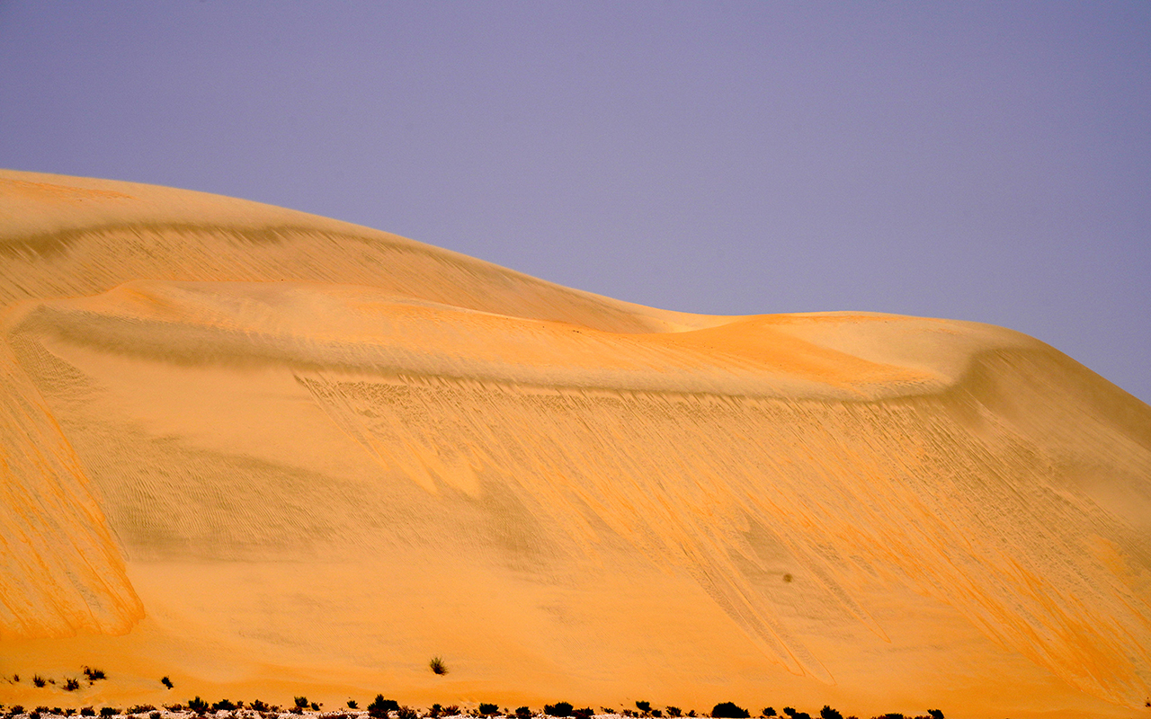
Al-Rub' Al-Khali Desert is composed of salt flats and dunes, some of which can reach up to 1,160 m above sea level and 210 m above ground level. Its sands glow with a reddish-golden hue, and beneath these sands lie the most important resources of Saudi Arabia of oil and gas.
Geographical landmarks in Al-Rub' Al-Khali Desert
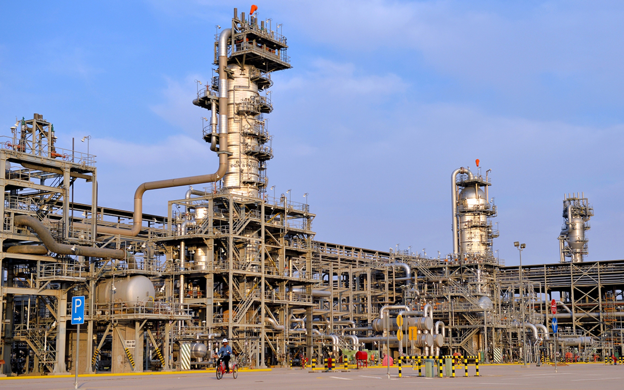
Ghawar and Shaybah Fields
In Al-Rub' Al-Khali, the Saudi Arabian Oil Company (Saudi Aramco) operates the world's largest crude oil field, Ghawar Field, with reserves reaching 58.32 billion barrels. It also operates in the Jafurah Desert, the largest non-associated gas field, whose reserves are estimated at two hundred trillion cubic feet of crude gas.
At the depth of the desert, specifically on the southeastern edges of Al-Rub' Al-Khali, the Shaybah oil field facilities discovered in 1968 are located, which contain a certain oil reserve of 14.86 billion barrels of oil equivalent.
Shaybah and Uruq Bani Ma`arid Reserves
Al-Rub' Al-Khali Desert is interspersed by two natural reserves designed to protect the scarce wildlife species within it: the Shaybah Reserve, managed by Saudi Arabian Oil Company (Saudi Aramco), covering an area of 637 km2, and the Uruq Bani Ma`arid Reserve, situated southwest of Al-Rub' Al-Khali, spanning 12,787 km2. This second reserve is under the administration of the National Center for Wildlife.
Al-Rub' Al-Khali border checkpoint
Al-Rub' Al-Khali border checkpoint is on the southeastern border of Saudi Arabia, and it is the only entry point that connects it with the Sultanate of Oman. The location of this checkpoint is within the al-Ahsa Governorate of the Eastern Province, just before the 657 km long border with Oman's Sultanate.
Al-Rub' Al-Khali checkpoint is one of the fourteen land border checkpoints under the management of the Ministry of Interior, represented by the Saudi Border Guard General Directorate and the Authority of Zakat and Tax and Customs Authority. These checkpoints connect Saudi Arabia with eight Gulf and Arab countries.
Al-Rub' Al-Khali checkpoint is connected to the Batha Border checkpoint to the north on the Saudi-Emirati border. This connection is through a land route that crosses Al-Rub' Al-Khali Desert. This road directly links Saudi Arabia to the Sultanate of Oman, extending for about 564 km. On the Omani side, the crossing is adjacent to the Ramlat Khaliya checkpoint.
Al-Kadan Area
Al-Kadan area is an extensive dune region located in the northeastern part of Al-Rub' Al-Khali. Al-Batin and al-Batinah bound it to the north, al-Jawas (al-Yawwah) and al-Dhafra from the north, al-Uruq al-Mutaridah, and al-Habak from the south. Al-Shaybah dunes, especially in the east, and al-Maharad from the west. The dunes of al-Kadan area descend generally eastward. The average elevation of its sands above sea level is approximately 150 m. Saline sabkhas are abundant in its eastern edges, particularly near the Shaybah dunes, and are less prevalent in other parts. Crossing it from the north is the Shaybah Road, established by Saudi Aramco. This road connects the Shaybah oil field complex to the company's facilities in Buqayq. Located on its northern edges is the Shubaytah Border Guard Center, under the administration of the Saudi Border Guard.3
Sand formations in al-Kadan Area
Al-Kadan area is distinguished by the diversity of its sand formations and the ruggedness of its terrain, especially in the central part. This area consists of mounds, pyramidal-shaped hillocks, and high and rugged ridges that are challenging to traverse except through specific passages known only by experienced people. Al-Kadan area is composed of crescent-shaped dunes and ridges in its eastern and southeastern parts, forming a western extension of the Shaybah dunes. At the same time, it consists of longitudinal dunes known as Hamarir al-Kadan in its western parts.
Al-Kadan Area resources
There is a wide range of water resources and artesian wells (Qalamat) that have been drilled by Saudi Aramco, including the northern, southern, and Kasah wells. Among its water resources are Khiran Ibn Aoun, Umm Ghafil, Aba al-Rawawil, and Aba al-Qurdan.
Al-Qamair Area
The term 'al-Qa'ameer' is used locally to refer to the Qama'ir Region. It is also known as al-Jaba'ir, and the name is applied to two areas, one to the east and the other to the west, separated by the Dukakah Region. The western area is more well-known. It's an area where vast sand dunes meet and intersect, with ridges and joints extending from the southwestern part of Al-Rub' Al-Khali, near the Sharurah and al-Wuday'ah governorates. This region is situated in the southern-central part of Al-Rub' Al-Khali, and it ends near the northeastern edges of al-Isharat, al-Marakhah, Marita, ar-Rawiy, Serdab, and Awbar, Sharifa, al-Manhar, al-Humaidah, and al-Badi' joints.
Al-Qamair Region resources
Al-Qamair Region is home to a vast array of ancient water resources and artesian wells, including Maamorah wells, Shanah, Warsah, Farijah, Khudhayfiyah, Ibn Suwailim, Tariwah, Abu Masjid, Wazm, Awbaar, Shareefah, Khiran al-Adhani, Mudaymitah, Aba al-Afan and Aba al-Oshush, al-Manahil, al-Atr, and artesian wells: Burayk and al-Madhhan. A paved road that runs through it, linking al-Kharkhir to Sharurah. Additionally, within one of its joints, there is the Juhaman Cave, a slight limestone elevation. The residents used to seek refuge in this cave to hunt gazelles that were attracted to the water surrounding it. Also, near the Maamorah wells in the Awbar section, there are some artifacts and pottery pieces.
Sabkhat al-Humr
One of the four sabkhas in Al-Rub' Al-Khali of Saudi Arabia is locally known as Batn al-Tarfa, and it is the largest in the area. The residents also call it Batn al-Tarfa, named after the Tarfa Mountains on its eastern edge. It is one of the lowest areas in Saudi Arabia, with its surface reaching approximately 24 m below sea level. It is situated south of the al-Bathaa border crossing with the United Arab Emirates and west of the Sabkha Mati. The course of Wadi al-Sahba used to end in this area but was blocked by the sands of al-Dhahna and al-Jafurah.
Sabkhat al-Humr site
Sabkhat al-Humr is situated in the Jaw al-Manayif area of the al-Jiban Region, between Batihin and the Saudi-al-Bathaa border checkpoint with the UAE, and west of Sabkha Mutayy. It is bordered by the al-Manayif Mountains to the northwest, the al-Muhna Mountains to the south, and the Tarfa Mountains to the east. The sabkha spans about 20km in length and 7km in width. The Shaybah Road runs to its west, and there are some historic water sources surrounding it on the eastern side.
Sabkhat al-Humr resources
Sabkhat al-Humr contains some springs that flow on its surface. In its center, there is a circular dune. It is bordered by the Shaybah Road to the west. Some of its most famous springs include al-Tarfa, al-Sajm Well, and the water sources of Ubay al-Daw and Ghadeer al-Zhillal. On its southern edges, there are some pools and swamps that formed as a result of the presence of springs emerging from the rocks of the area. Grasses and shrubs also grow along its watercourses.
Al-Shaybah Dunes
Al-Shaybah Dunes is a high and rugged dune located northeast of Al-Rub' Al-Khali in Saudi Arabia. It is bordered to the north by the path of the international boundary line between Saudi Arabia and the United Arab Emirates, Ramlat al-Rabadat, Ramlet Zurarat, al-Bateen, and al-Jawaa (al-Yawaa) located in the UAE, and to the south by Ramlat al-Ghafa and al-Uruq al-Mutaridah, from the east Ramlet al-Ghafa, Sabkhat Umm al-Sameem, and al-Jeddah, and from the west al-Kadan.
The Shaybah Dunes are composed of complex crescent-shaped sand ridges that are intertwined and overlapping in most parts. They consist of small dunes that have grown on their surfaces and depressions known as interdune areas that are rugged and uneven. The Shaybah Dunes are characterized by their elevation above the surrounding terrain, especially in their western parts. Some dune crests can rise to two hundred m above their surroundings. Crossing these dunes is challenging and usually requires specific routes. In contrast, the dunes expand and become more dispersed towards their eastern edges, transforming into complex longitudinal walls with star-shaped dunes on their crests. The dunes of al-Shaybah generally extend from west to east and are among the most challenging and rugged regions of Al-Rub' Al-Khali. Its crescent-shaped dunes have steep southern-facing slopes and include wide low-lying joints between them, most of which are covered by moist salt flats. The altitude of its joints varies between fifty to one hundred m above sea level.
The sandy landscapes of the Al-Shaybah Dunes
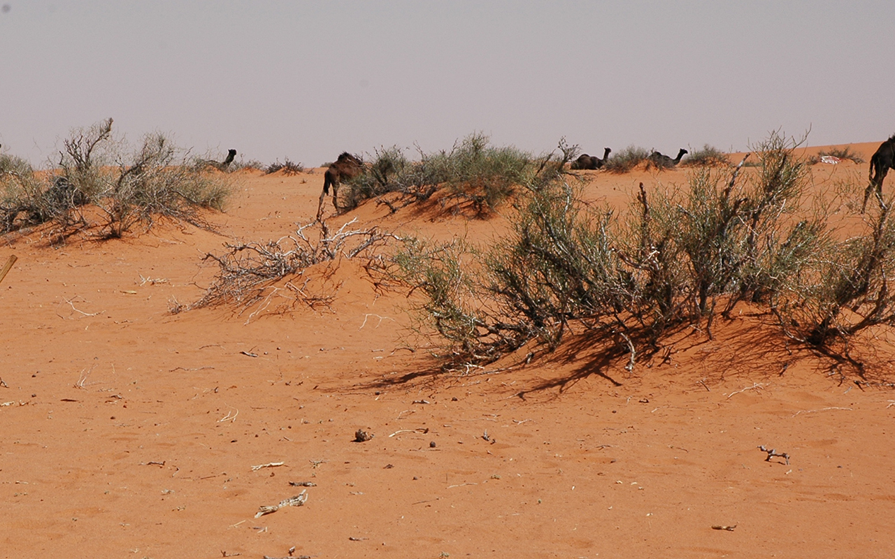
Some of the sandy landscapes in the al-Shaybah dunes include al-Alqa'a, Mubkhut, al-Sindi, Ibn Yamana, al-Manahil, al-Mankhaz, al-Zubaa, al-Qata', Ibn Anooda, Neela, Ramlah Ibn Saeedan, Abu Maryakha dunes, al-Saart dunes, Umm al-Zumool dunes, Marazam joint and Sabkhat al-Azzaf. The vegetation dominating the al-Shaybah dunes includes Cornulaca (al-Hadh,) Calligonum Comosum (al-Abal,) al-Andab, and al-Zahr. Additionally, Haloxylon ammodendron (al-Ghada) grows on its eastern edges.
Botanical landmarks of Al-Rub' Al-Khali Desert
Cornulaca Monacantha
It's commonly abbreviated as 'Hadh' with the plural being 'Ahwadh.' It is a plant from the Capparaceae family and the Rotala genus. It is widespread in Al-Rub' Al-Khali Desert of Saudi Arabia and is the second most common plant there after al-Abal. It is densely concentrated in specific locations in the Eastern and Central regions.
The Hadh plant is a branched woody shrub with short bluish-green leaves that turn white or yellow when the plant dies. Its edges are coarse, and each flower extends with a single petal. It produces an orange or brown fruit that usually grows in the summer.
The Hadh extends in Al-Rub' Al-Khali Desert in the form of a strip from the east to the west. Many of those regions were named with terms derived from their name, including Hadh Jamshan, Hadh al-Fidaa, Hadh Shikwa, Hadh al-Bouh, Hadh Fares, Hadh Bani Zainan, Hadh al-Shuweikla, and Hadh al-Utrat.
Calligonum
Calligonum, al-Abal, is a leafless shrub from the Polygonaceae family. It thrives in desert environments and is considered a medium-height plant or shrub. It always has green branches that are hard and drooping. Its stems grow with sand accumulating around them. It has seasonal flowers that bloom in the spring; they are white, tend to be yellow, and some are red. Its fruits are spherical with soft thorns.
The Calligonum tree is widespread in the desert of Saudi Arabia, and it is the most prevalent plant in Al-Rub' Al-Khali. It is distributed throughout most of its regions, and it is densely concentrated in some eastern, southern, southwestern, and southeastern regions. It also grows in some central parts. It is prevalent in areas such as al-Habak, al-Uruq al-Mutaridah, al-Qa'd, al-Sawahib, the dunes of al-Awarik, and al-Abal, with one of the most notable being Abal Ghamghima.
The Calligonum plant grows on dunes, aiding in stabilizing them. Its long taproots allow it to access water deep underground. It also thrives in flat terrains and valleys. Often, it's planted around farms as a windbreak. This shrub rapidly grows on dunes and gravelly and rocky soils. It doesn't require much water and can withstand the harsh, hot climate.
Calligonum shrubs are planted along roadways as sand stabilizers. They are versatile and can be found in city centers, at entrances, in courtyards, along roads, and in yards. The shrub is multi-functional. It serves as a barrier in preventing desertification and is crucial for camel grazing. Its branches can be utilized as firewood and its flowers, which have a fragrant scent, are also edible. The shrub can reproduce through both seeds and cuttings.