Volcanoes in the Kingdom of Saudi Arabia are geological activities and natural phenomena in the Earth's crust at some locations in the Kingdom, emitting molten materials from the Earth's interior, including solid, liquid, and gaseous components.
History of volcanoes in Saudi Arabia
The formation of volcanoes in the Kingdom dates back to about thirty million years ago and occurred in two phases: the first coincided with the flow of basaltic lava and the rifting of the Red Sea, and the second with the onset of volcanic activity in the Arabian Peninsula about ten million years ago.
Volcanic activity in the Kingdom ceased about eight centuries ago, with al-Malsa Volcano on the outskirts of the northern and southern parts of Harrat Rahat, southeast of al-Madinah al-Munawwarah, being the most recently active volcano. It witnessed the flow of lava reaching near the eastern outskirts of the city in 1256.
Volcanoes in the Kingdom stretch from its southern borders to the northern borders with Jordan. The magma of volcanoes can reach high temperatures of about 1,200°C.
Harrats and volcanoes
Volcanoes are known by several names in Arabic, including 'Ataam al-Niran,' and in the Kingdom, they are referred to as Harrat. A Harrah is 'a land with black stones as if burnt with fire,' named so due to the intense heat of its rocks to those who traverse it.
A Harrah includes cones and craters, along with their outputs of lavas, ash, and more. The term Harrah, pluralized as Harrat, refers to basaltic flows formed from molten volcanic rock lava that flowed from the Earth's interior to its surface through volcanic craters as a result of tectonic and seismic activities.
The formation of Harrat in the Kingdom dates back to the Cenozoic and Quaternary periods, resulting from volcanic flows that accompanied the fracturing of the Red Sea rift. Their formation occurred between five and thirty million years ago.
Types of Harrat in Saudi Arabia
The Kingdom encompasses two types of Harrat, the first of which are flows of highly metamorphosed dacite and rhyolite, along with corresponding fragments and volcanic ash that have formed hills from the Miocene era above the Red Sea coast. These appear in the southwest of the Kingdom near the border with Yemen. The second type consists of basaltic flows that form plateaus from the Miocene 'Holocene' era, exposed above the Arabian Shield. According to their size, they are considered one of the most important volcanic units in the Kingdom, and this type spreads along a single axial line that runs from north to south, known as the 'Makkah-Madinah volcanic line.'
Distribution of Harrat in Saudi Arabia
The Kingdom hosts numerous Harrat, whose distribution is linked to intense tectonic movements 'fracturing and faulting' associated with the rifting of the Red Sea. This rift began to form at the end of the Oligocene or the beginning of the Miocene epoch, a time when the Arabian and African continental masses were in the process of separating.
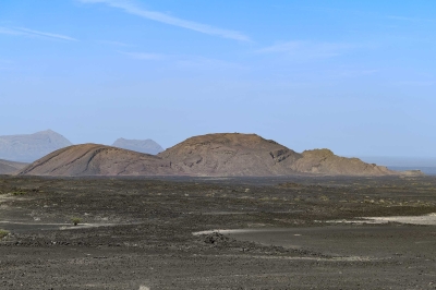
Volcanoes in the Kingdom are classified into several types, including: volcanic domes, scoria volcanoes, shield volcanoes, volcanic craters, in addition to basaltic lava, among others. The majority of the volcanic rocks in the Kingdom consist of alkali olivine basalt.
The total area of the Harrat in the Kingdom is approximately ninety thousand km, which constitutes about 4.6 percent of the total area of the Kingdom, spanning around two million km. Harrat are distributed across nine administrative provinces, namely: Makkah al-Mukarramah, al-Madinah al-Munawwarah, Tabuk, al-Jawf, the Northern Borders, Hail, al-Bahah, Aseer, and extending to Jazan Province.
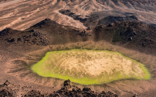
Harrat Rahat is considered the largest volcano in the Kingdom by area,covering twenty thousand km.It is followed by Harrat Khaybar, Harrat al-Harrah, and Harrat Nawasif, leading to Harrat Kishb, which includes the Wa'bah Crater, also known as 'Maqla' Tamia.' This crater is the deepest and widest volcanic crater in the Kingdom, with a diameter of two km and a depth exceeding 220 m.
Benefits of volcanoes
Despite the known hazards of volcanoes, they offer a number of benefits, including: the healing properties of water from springs and geysers distributed around the volcano, the extraction of minerals and gemstones such as peridot and diamonds, the use of volcanic gas emissions as a source of energy, the production and manufacturing of certain chemicals from sulfur deposits, and the use of their rocks in construction materials and road paving.
Volcanic activity monitoring in Saudi Arabia
The Saudi Geological Survey is responsible for monitoring all volcanic activities, conducting related studies and research, and issuing warnings in the event of any potential hazards. This includes the establishment of the volcanic and seismic hazard alert system, which consists of four levels of alert:
Green: Indicates a normal or dormant volcanic activity status.
Yellow: Signifies an increase in seismic and volcanic activity above normal levels, with the possibility of persistence of this increase.
Orange: Indicates increased volcanic disturbances with a possibility of eruption, but without precise timing.
Red: Symbolizes imminent eruption danger, potentially involving significant volcanic ash emissions.
Related quizzes


