Geography of Saudi Arabia
The Geography of the Kingdom of Saudi Arabia reflects the manifestations of the geological and natural structure of the Kingdom, as well as its climate. The Kingdom holds a strategic geographical location at the heart of three continents: Asia, Africa, and Europe. Specifically, it is situated in the far southwest of the Asian continent. The Kingdom is bordered to the west by the Red Sea, to the east by the Arabian Gulf, the United Arab Emirates, and Qatar, to the north by Kuwait, Iraq, and the Hashemite Kingdom of Jordan, and to the south by Yemen and the Sultanate of Oman. Its official name was declared after its unification in 1932 by King Abdulaziz Bin Abdulrahman Al Saud.
Saudi Arabia's location
The Kingdom boasts three seafronts, with coastlines extending approximately 3,800 km. One of these seafronts lies along the Red Sea, while the remaining two are situated along the Arabian Gulf. It overlooks both the Gulf of Aqaba and the Red Sea from the west, with a coastline spanning approximately 2,600 km. This includes around 180 km along the Gulf of Aqaba coast. The Kingdom holds the top position among countries flanking both sides of the Red Sea when it comes to the length of its coastline. Around 80 percent of the eastern coast of the Red Sea falls within its borders.
The Kingdom is also characterized by its extensive coastal stretch along the east of the Arabian Gulf. This comprises two coastlines spanning approximately 1,200 km. The first is the northern coastline, which extends from the coastal border checkpoint of the neutral zone in the Saudi-Kuwaiti partitioned zone to the coastal border checkpoint with the State of Qatar on the Gulf of Salwah (Dawhat Salwah), covering a distance of about 1,100 km. The second is a southern coastline that begins at the coastal border checkpoint with the State of Qatar near the entry to Khawr al-Udayd in the Arabian Gulf and extends to the coastal border checkpoint with the United Arab Emirates at Dawhat as-Sumayrah, covering a distance of around one hundred km.
Saudi Arabia's area
The Kingdom commands the largest area among the neighboring countries in the Arabian Peninsula, encompassing over two million km This region displays significant terrain diversity, featuring narrow plains along the Red Sea coast (Tihama Plains). Progressing eastward, there are mountain ranges traversing the Kingdom's length (Hijaz and Aseer mountains, with peaks soaring beyond three thousand m). Subsequently, the central region encompasses deserts and rocky plateaus (accounting for 90 percent of the overall area). Nufud Desert is the largest to the north and the Empty Quarter to the south. Along the coast of the Arabian Gulf to the east, wide coastal plains extend.
Since 1992, the Kingdom has been officially divided into thirteen administrative provinces. Many of its residents inhabit the coasts of the Red Sea and the Gulf of Aqaba, as they fall within the territories of five administrative provinces in the Kingdom: Makkah al-Mukarramah, al-Madinah al-Munawwarah, Tabuk, Aseer, and Jazan.
Astronomical position
The Kingdom covers a substantial area of the Arabian Peninsula, comprising approximately two-thirds of its expanse. Its territories extend between latitudes 16° 22’ 46” and 32° 14’ 00” N, and longitudes 34° 29’ 30” and 55° 40’ 00” E. Running through its central region is the Tropic of Cancer (30° 23’ N).
The Kingdom's cadastral dimensions reveal that its widest span is a line in the south extending from Jazan in the west, traversing Yemen, to the west of Oman Mountains in the far east, measuring a total of 1,700 km. On the other hand, its longitudinal extension attains its maximum from Anazah Mount, the northernmost point where the Kingdom's borders converge with those of Iraq and Jordan, extending to the southern reaches of the Empty Quarter, north of Dhofar, Oman, covering a length of 2,200 km.
Regarding the positions within these extensions, the first longitude crosses Ras Sheikh Humaid at the entry to the Gulf of Aqaba, while the second longitude runs close to the Buraimi Oasis, situated west of the Oman mountain range. This suggests that the Kingdom spans approximately 22° of longitude.
Geographical map of Saudi Arabia
The geographical map of the Kingdom displays a longitudinal aspect, with its lands taking on a shape that generally tends to elongate and converge. The geometric structure is notably an irregular hexagon, with its six sides corresponding to the political borders of the country in all directions. This unified shape offers numerous advantages to the Kingdom, most notably the cohesion of its regions, as they are not divided by bodies of water.
In this area, the Kingdom comprises five planning regions delineated for planning purposes nearly four decades ago. Each planning region encompasses multiple administrative provinces, namely:
The central region: Riyadh and Qassim.
The western region: Makkah al-Mukarramah and al-Madinah al-Munawwarah.
The Eastern Province: It is the planning region that is referred to as a planning and administrative region simultaneously. It is the largest in terms of area.
The northern region: Hail, Northern Borders, al-Jawf, and Tabuk.
The southwestern region: Aseer, al-Bahah, Jazan, and Najran.
Geographic location
Due to its expansive area and central position, the Kingdom shares long land borders with seven countries (the United Arab Emirates, Qatar, Kuwait, Iraq, Jordan, Yemen, and Oman), totaling a length of 4,531 km. The Kingdom’s southern border with Yemen is the longest.
Saudi Arabia's borders
With the establishment of the Third Saudi State and the consolidation of its foundations and pillars, King Abdulaziz Bin Abdulrahman Al Saud demonstrated a commitment to delineating and demarcating both land and maritime borders with neighboring countries. He was undertaken to protect the Kingdom's rights and interests. Consequently, agreements were reached with all neighboring countries to delineate and demarcate land borders, marked physically between them. The Kingdom also entered into agreements with most neighboring and facing countries situated along the Arabian Gulf, the Gulf of Aqaba, and the Red Sea, aiming to establish clear maritime borders between them.
Apart from being surrounded by seven Arab countries along its land borders, the Kingdom also faces other nations along its maritime borders. Along the Arabian Gulf, it overlooks the Islamic Republic of Iran and the Kingdom of Bahrain. In the Gulf of Aqaba, it faces the Arab Republic of Egypt, and in the Red Sea, it is faced by the Arab Republic of Egypt, the Republic of Sudan, and Eritrea.
The neighboring countries are connected to the border regions of the Kingdom, as seven provinces are situated along the land borders with neighboring countries. To the north, these regions include Tabuk, al-Jawf, the Northern Borders, and the Eastern Province. To the east, it comprises the Eastern Province, while to the south, it encompasses the Eastern Province, Najran, Aseer, and Jazan.
As a result, the Kingdom's coastline on the Arabian Gulf falls within the territory of the Eastern Province, while its coastline along the Gulf of Aqaba and the Red Sea is located within the territory of five administrative provinces: Tabuk, al-Madinah al-Munawwarah, Makkah al-Mukarramah, Aseer, and Jazan.
Maritime zones
A dedicated maritime zones system was issued by a royal decree in 2010. This system mandates that the baselines for the Kingdom's maritime zones in the Gulf of Aqaba, the Red Sea, and the Arabian Gulf align with the sets of geographical coordinates outlined in three tables appended to the royal decree. These tables delineate the geodetic datum reference for these coordinates.
According to the system, Table No. One comprises a list of geographical coordinates for 103 basepoints in the Gulf of Aqaba and the Red Sea. These coordinates start from a basepoint on the maritime border line between the Kingdom and the Hashemite Kingdom of Jordan in the Gulf of Aqaba, extending to a basepoint on the maritime border line between the Kingdom and the Republic of Yemen in the Red Sea.
Regarding Table No. Two, it comprises a list of geographical coordinates for eleven basepoints in the Arabian Gulf, starting from a basepoint on the dividing line of the submerged area adjacent to the partitioned zone between the Kingdom and the State of Kuwait, extending to a basepoint on the maritime border line between the Kingdom and the Kingdom of Bahrain.
Table No. Three includes a list of geographic coordinates representing four basepoints. The coordinates start from a basepoint along the maritime border line beyond Khawr al-Udayd, between the Kingdom and the State of Qatar, extending to the basepoint located at the coastal border point between the Kingdom and the United Arab Emirates. These lists were formally submitted to the United Nations in 2010.
To bolster the significance of that system in safeguarding the Kingdom's rights, a royal decree was issued in 2011 approving the Kingdom’s Maritime Zones Law. The law consists of twenty-three articles, elucidating the Kingdom’s rights and responsibilities within its maritime zones.
The total area of inland waters is estimated at about 79,200 km
Population
The Kingdom boasts a cultural homogeneity and social diversity that have contributed to crafting a rich identity for its population, which stands at around 32,175,224 individuals. Saudis make up roughly 58.4 percent of the populace, while non-Saudis account for 41.6 percent. The gender breakdown reveals approximately 61.2 percent males and 38.8 percent females, distributed across thirteen administrative provinces, as per the 2022 Saudi Census.
The average population density in the Kingdom is approximately 16.4 people per km
Saudi Arabia's geology
The Kingdom boasts extensive geological diversity across its diverse regions, with its territories undergoing numerous transformations throughout history. These changes have contributed to shaping the diverse terrains found across its geographical expanse.
Geological history
The territories of the Kingdom are linked to various geological occurrences documented in ancient history. The emergence of the Kingdom’s first detailed geological study dates back to 1930, when geologists directed special attention to the Arabian Peninsula, driven by the anticipation of uncovering oil, particularly in the Eastern Province that eventually became the world’s main oil region. The Kingdom claimed the top position in terms of having the largest established and confirmed oil reserves globally (one-quarter or 25 percent of the world's reserves).
The geological map of the Arabian Peninsula highlights its status as one of the rarest geographical areas in the world in terms of geology, boasting rocks that span all geological eras. These rocks exhibit diversity, encompassing continental, marine, and transitional depositional environments. The igneous rocks in the Arabian Shield range from 2,400 million years to 542 million years ago, whereas the sedimentary rocks in the Arabian Plate date back from 542 million years ago to the present day.
These geological variables have contributed to making the Kingdom a natural repository for a wide range of underground resources. Simultaneously, the Arabian Peninsula, where the Kingdom holds the largest share, has experienced diverse and fluctuating climatic changes in recent history, including ice ages, periods of rainfall, and dry spells. These fluctuations have had notable effects on the local wildlife, flora, and fauna. Geographers have classified the world into three biogeographic kingdoms, each exhibiting regional traits in terms of flora and fauna. It is widely acknowledged among scholars that the Arabian Peninsula is positioned at the crossroads of these geographical regions.
Geological components
The Kingdom's territories boast numerous geological components, with the geological division featuring four main ranges. They are:
The Arabian Shield: It covers the majority of the western region of the Kingdom, running along the shores of the Gulf of Aqaba and the Red Sea. Stretching from the border with Jordan to the north to the border with the Republic of Yemen to the south, it encompasses an area of approximately 630,000 km
The Arabian Shield consists of basalt rocks of igneous and metamorphic origin, dating back to the Precambrian era. Consequently, these rocks are recognized as the oldest formations in the Arabian Peninsula, spanning ages from 450 million to one billion years. There is also evidence indicating the existence of rocks approximately 1,600 million years old.
The Arabian Plate: Also referred to as the Arab Plate, it is situated to the east of the Arabian Shield. It encompasses approximately two-thirds of the Kingdom's area, equivalent to around 68 percent, spanning an area of approximately 1,320,000 km
Throughout history, sediments accrued during the Paleozoic era (spanning from the Cambrian to the Permian period) predominantly consisted of sandstone and shale resulting from the deposition of sand and clay in marine environments. In contrast, sediments formed in the Mesozoic and Cenozoic eras exhibited a limestone composition, originating from the evaporation of ancient seawater, complemented by the presence of sand and valley sediments. The sedimentary rocks found in the Arabian Plate not only house oil and gas resources but also contain deposits of non-metallic minerals (nonmetal), such as bauxite, phosphate, clay, limestone, and others. Furthermore, these rocks harbor deep water reservoirs within the Kingdom.
Lava fields: They were formed in the Kingdom during the Cenozoic and Quaternary eras due to volcanic activity linked to the Red Sea Rift's formation. Their formation occurred between around thirty million years ago and approximately eight hundred years ago.
Red Sea Coastal Plain: The Red Sea coastal plain forms the eastern edge of a wide ridge (Red Sea Rift) bordered to the east by the western highlands. It has expanded and stretched due to the Red Sea floor spreading.
Rock formations
Considering the diverse geological features present in the Kingdom's terrains, numerous rock formations originating from various geological eras can be identified. These formations include:
Archaean (Precambrian) formations: The rocks from this era are widespread in the Arabian Shield region. Archaean rocks serve as the foundational basement rocks upon which the rock formations of subsequent geological periods developed.
Paleozoic formations: They constitute the first sedimentary cover above the ancient Archaean basement rocks, spanning extensive areas within both the northern and southern sedimentary basins. Paleozoic rocks are primarily formed of sandstones and go by various formation names, such as Saq formation, Tabuk formation, and al-Jawf formation. The latter is economically significant as it harbors the Kingdom's crucial deep groundwater reservoirs.
Mesozoic formations: These geological formations cover extensive areas, compared to those of the Paleozoic era. They manifest as a broad arc strip situated to the east of the Paleozoic rocks. Geographically, they stretch from the Kingdom's border with Jordan to the Empty Quarter in the south, predominantly composed of limestone and sandstone.
Cenozoic formations: They extend across the northern and eastern regions of the Kingdom, stretching beyond the sands of ad-Dahna' and an-Nufud al-Kabir. The distinctive feature of rocks from this era lies in their sandy composition, characterized by flat layers that slightly slope towards the east and incorporate occasional small domes.
Quaternary formations: Quaternary formations have a direct impact on the nature and arrangement of the Kingdom's terrains. The conclusion of the Pliocene and the onset of the Pleistocene were marked by a moist climate, primarily attributable to three major rivers: Wadi Rumah - al-Batin to the north, Wadi Hanifah - as-Sahba' in the central area, and Wadi ad-Dawasir to the south. Originating from elevated terrains and plateaus in the west, these rivers transported rock fragments and weathering byproducts eastward, resulting in the deposition of substantial amounts of sediment.
Volcanic rocks: They were formed during the Cenozoic and Quaternary eras after the fracturing of the Arabian Shield territories (unit/region) and the eruption of volcanic magma that solidified into volcanic cones or volcanic fields (Harrat) Black Basalt is the most famous among them.
The oldest rocks in the Arabian Peninsula are found in the Arabian Shield, forming the foundation upon which the rocks of the Arabian Plate were deposited. Approximately 25 million years ago, before the emergence of the Red Sea Rift, the Arabian Shield was connected to the African continent. Mineral sediments in the Kingdom, including gold, silver, and copper, are predominantly found in Precambrian rocks. The extensive sedimentary rock area situated in the eastern and northern regions of the Kingdom constitutes the Arabian continental shelf, estimated to be less than 540 million years old. These rocks, known as sedimentary cover rocks, overlay the rocks of the Arabian Shield.
In general, the Arabian Shield stands out as one of the geological components in the Kingdom, initially comprised of plutonic rocks with additional volcanic or sedimentary overlays. Three sets of granite have been recognized and organized in ascending order based on their age:
1- The ancient granite and granite gneiss. They primarily derived from the transformation of schist and ancient volcanic rocks into granite and date back approximately one billion years.
2- Calc-alkaline grey granite, dating back about 750 million years.
3- Modern eruptive rocks consisting of granite rich in soda, syenite, and non-metamorphosed rhyolite. These rocks are scattered in narrow areas, with their earliest age estimated to be approximately 500 million years.
Al-Harrat
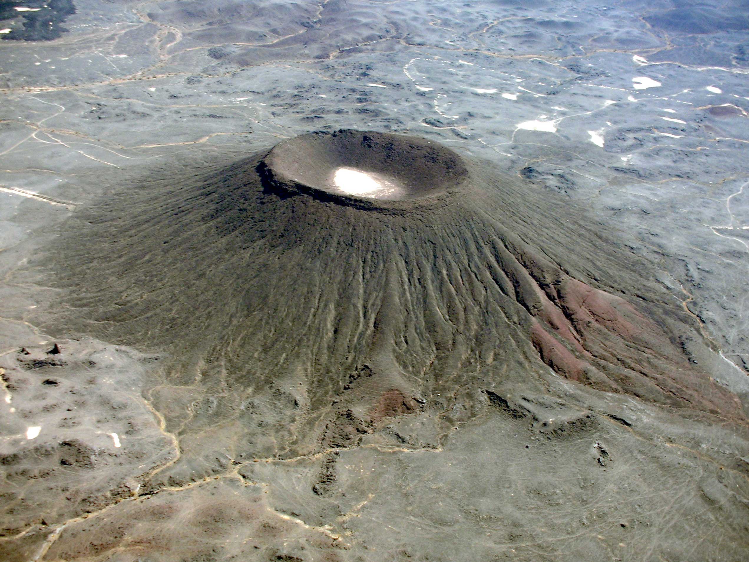
Owing to geological transformations over the Kingdom's history, volcanic fields (known as al-Harrat in Arabic) have surfaced. These fields consist of basalt outcrops resulting from molten volcanic rocks' lava. This lava emerged from the Earth's interior to the surface through volcanic craters, triggered by kinetic and seismic activities. Presently, in the Kingdom, the term al-Harrat is employed to denote volcanoes, encompassing their cones, craters, and emissions, such as lava and ash.
The formation of al-Harrat in the Kingdom can be traced back to the Cenozoic and Quaternary eras, resulting from volcanic activity associated with the formation of the Red Sea Rift. Mainly located in the western region of the Kingdom, the majority of al-Harrat comprises alkali basalt rocks. These formations predominantly overlay the rocks of the Arabian Shield and extend from the southern to the northern regions of the Kingdom along the volcanic line (Makkah – al-Madinah - al-Nufud), at approximately 40° E longitude.
Due to their abundance, al-Harrat in the Kingdom cover approximately ninety thousand km², accounting for about 4.6 percent of its area. Harrat Rahat is considered the largest Harrat in the Kingdom in terms of area, spanning about twenty thousand km².
The volcanic line (Makkah – al-Madinah - al-Nufud), commonly abbreviated as MMN, represents the Kingdom's lengthiest expanse of al-Harrat, stretching up to nine hundred km. It is a rift that widens at a rate of 0.054 mm annually, a path parallel to the 40° E longitude. Harrat Hutaymah and al-Harrah stand out as the only two Harrat in the Kingdom to be formed far from its western border.
The Kingdom is home to twenty-three Harrat, with the most significant and extensive ones including al-Harrah, ar-Raha, Uwayrid, Hutaymah, al-Shaqa, Khaybar, Thinan (Ithnan), Rahat, Kishb, Hadan, Nawasif, as-Sarah, and al-Barak. Additionally, there are other smaller, scattered Harrats that are predominantly situated in the Tihama Plain. Al-Malsa Volcano, positioned on the northeastern outskirts of Harrat Rahat, southeast of al-Madinah al-Munawwarah, is considered the most active volcano in the Kingdom. Notably, it experienced a lava flow that reached near the eastern outskirts of al-Madinah al-Munawwarah in 1256.
Saudi Arabia's topography
The Kingdom is characterized by significant terrain diversity owing to its extensive geographical expanse. Stretching along the Red Sea is the Tihama coastal plain, spanning approximately 1,100 km in length. It widens to sixty km in the south and gradually narrows as it extends northward to the Gulf of Aqaba. To the east of this plain, the Sarawat mountain range emerges, featuring high peaks that reach nine thousand ft in the south. The elevation gradually diminishes northward, reaching three thousand ft.
These terrains encompass expansive valleys descending from the mountains in both eastern and western directions. Examples include Wadi Jazan, Wadi Najran, Wadi Tathlith, Wadi Bishah, Wadi al-Hamd, Wadi Rumah, Wadi Yanbu, and Wadi Fatimah. Extending eastward from this range is the Najd Plateau with its highlands, terminating in the east with ad-Dahna' dunes and as-Summan desert. To the south, it is interspersed with Wadi ad-Dawasir, bordering the Empty Quarter desert.
There are also extensive plains, with the Najd plains stretching from the north to Hail Province, connecting to an-Nufud al-Kabir desert, and reaching the borders of Iraq and Jordan. Additionally, there are mountainous highlands, such as the Tuwayq, al-Arid, Aja, and Salma mountains. The Empty Quarter desert forms the southeastern portion of the Kingdom, a large desert region characterized by expansive sand dunes and sabkhat. The eastern coastal plain, extending approximately 610 km, is comprised of salt sabkhat and sandy areas.
Given the Kingdom's diverse, rich terrain, encompassing mountains, plateaus, plains, valleys, and diverse sand dunes, certain terrain features occasionally take precedence. Hence, its lands are often characterized as the Arabian Plateau, given that its plateaus make up no less than 60 percent of the total area. The Najd Plateau alone constitutes approximately 21 percent of the Kingdom's area.
In a broader context, the surface features in the Kingdom are categorized into several main sections or regions, including:
Coastal plains: The Red Sea coastal plain (the Hejaz Plain and the Tihamah Plain), the eastern plains (al-Ahsa Plain and the Arabian Gulf coastal plain).
Western Highlands: range of coastal hills and elevated highland ranges.
Plateaus: Western plateaus, Najd plateau, eastern plateaus, and northern plateaus.
Deserts and sand ergs (landforms): Key sand seas: An-Nufud al-Kabir, ad-Dahna', al-Jafurah, the Empty Quarter.
Plains
Plains constitute integral components of the Kingdom's topography. Along the extent of the coastlines on the Red Sea and the Arabian Gulf, two coastal strips and two plains are found. They are:
Red Sea Coastal Plain (Tihamah Plain):
The Red Sea coastal plain forms the eastern edge of a wide ridge (Red Sea Rift) bordered to the east by the western highlands. It has expanded and stretched due to the Red Sea floor spreading. Constituted of sedimentary rocks, coral reefs, and surface sediments from the late Cenozoic and Quaternary eras, the Red Sea coastal plain features sedimentary rocks with a thickness reaching approximately five thousand m.
This plain is confined between the Red Sea coast to the west and the western highlands to the east. It serves as a narrow transitional zone between the Red Sea plate and the elevated al-Jarf mountains. Expanding in the south, its width reaches approximately forty km near the city of Jazan. It gradually narrows towards the north until it vanishes around the latitude of 26° N, south of the city of al-Wajh, except for some segments near the northern end of the Red Sea. This plain is characterized by numerous marine capes, including Ras Karkuma, Ras al-Shaban, Ras al-Baridi, Ras Hatba, Ras Kashran, Ras Muhaisin, and Ras al-Tarfa.
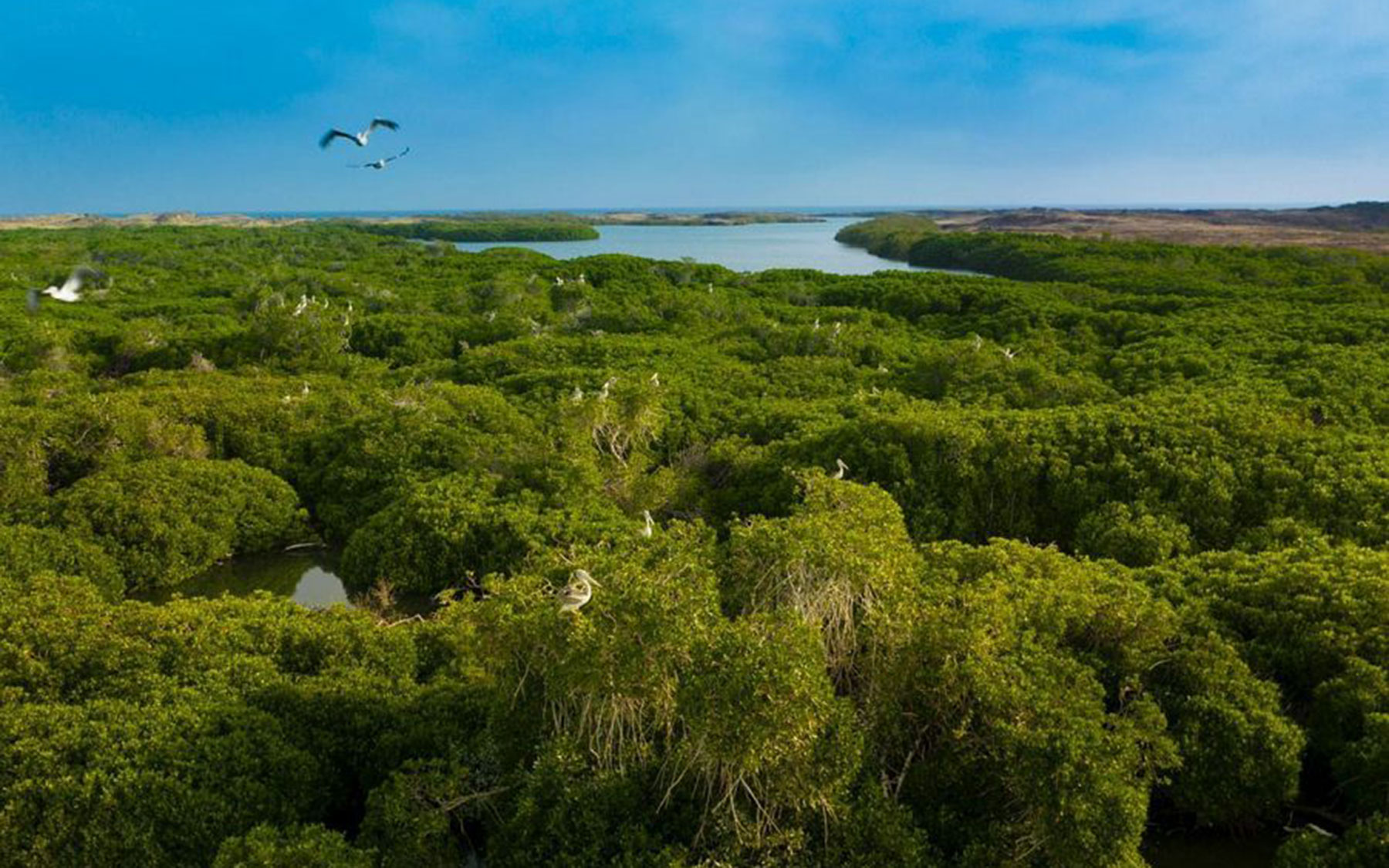
The northern half of this plain is distinguished by numerous sea coves—small sea inlets extending inland along watercourses descending from coastal mountains. Notable among them in the north are the coves of Yanbu, Rabigh, and Obhur. On the other hand, the southern half of the plain is marked by an abundance of khawr—estuaries akin to the coves but distinguishable by their capacity and shallowness. Among these estuaries are Khawr al-Shuaiba, Khawr al-Sawda', Khawr al-Zawahir, and Khawr Amq. The coastal plain is intersected by valleys with steep slopes and deep streams that flow into the Red Sea. Salt flats (Sabkha) are widespread in this plain, and there are also sand clusters near the coast, along with the presence of small Harrat.
Arabian Gulf Coastal Plain:
The Arabian Gulf coastal plain lies between the Gulf's coastline to the east and as-Summan Plateau to the west. This expansive plain contains substantial areas covered with sand and salt flats (Sabkha), particularly in proximity to and along the coast. Notable for the absence of valleys, it features numerous Khawr, capes, and small gulfs (dohat), including Khawr al-Khafji, as well as the capes: Ras Mishab, Ras as-Saffaniyyah, Ras al-Khayr, Ras Tanaqib, Ras Tannurah, Ras Khathaq, and Ras Abu Qamis. This is in addition to the dohat of Salwa, Hamah, Duwayhin, and as-Samira.
This plain features the lowest area in the Kingdom situated at its southern extremity, namely Sabkhat al-Humr (Batn al-Tarfa'), positioned south of the Batha inlet, and approximately twenty-four m below sea level. Additionally, this plain encompasses certain agricultural oases, including the oases of al-Ahsa and al-Qatif.
Deserts
The Kingdom features extensive sandy desert regions, and its east is particularly renowned for sand accumulations. Approximately 66.6 percent of the total sand in the Kingdom is concentrated within its borders, equivalent to two-thirds of the area. The largest among these deserts is the Empty Quarter, spanning an area of 430,000 km², followed by an-Nufud Desert.
These sand accumulations stand as a natural landmark in the Kingdom's territories, covering a significant portion of its area—approximately 635,000 km², equivalent to about thirty-three percent of its area. The sands of the Empty Quarter, an-Nufud al-Kabir, ad-Dahna', and al-Jafurah, are recognized as the largest sand seas within the Kingdom, constituting approximately 90 percent of the overall sand accumulations in the Kingdom.
These accumulations developed due to various factors and reasons, including the availability of sediment sources, watercourses, intense winds, and diverse terrains conducive to aggradation. Sand accumulations in the Kingdom form from two primary sources: continental sand, which originates from the Arabian Shield, and marine sand, sourced from the Arabian Gulf.
Sand accumulations in the Kingdom take on different shapes: longitudinal, crescent, star, dome, transverse, and sand sheets. The designation of these sand features and landscapes varies from one region to another. Among these designations are Batra’, Beniya, Jazma’, Jara’, Habal, Haqnah, Houma, Khub, Khal, Rabbad, Rithmah, Zibara, Shiqqa, Torowza, Ti’as, Irq, Alam, Qawz, Milsa, Naziya, Nazira, and Niqa.
Empty Quarter Desert
It is a sandy expanse covering a total area of 430,000 km
An-Nufud al-Kabir Desert
It is one of the topographic features in the Kingdom, taking the form of a triangle with its base to the west. Encompassing an area of 65,000 km², it is confined by al-Hamad and al-Hajrah Plateaus in the north and at-Taysiyyah Plateau in the south. It has been identified by various ancient names, such as 'Ramlet Alaj' and 'Ramlet Bahtar.' The sand dunes within this depression are characterized by their elevated height in the west and south, with an increase in thickness in these directions.
Ad-Dahna' Desert
It is the most expansive desert, stretching from north to south in the shape of an arc or crescent and open to the west. It spans a length of 1,200 km, linking an-Nufud al-Kabir and the Empty Quarter. Serving as a natural demarcation between the Najd Plateau to the west and the eastern plateaus (ad-Dibdibah and as-Summan to the east), eight distinct series of sand ergs can be identified.
Mountains
The west and south of the Kingdom boast numerous mountainous areas, as well as the western highlands, formed of a mountain range that extends along the coasts of the Gulf of Aqaba and the Red Sea, spanning from the Kingdom’s northern borders with Jordan to the southern borders with the Republic of Yemen. Recognized as the most significant topographical feature in the Kingdom, these mountains are characterized by their ladder-shaped, block mountain formation. Their western face, particularly in its southern part, descends sharply towards the Red Sea, while their eastern slope gradually descends towards the interior regions of the Kingdom. Generally, their elevation increases towards the south, with the highest peak, Jabal as-Sudah, reaching approximately 3,015 m, situated north of the west of Abha city.
By extending over considerable distances, the western highlands are divided into three primary sections:
Sarawat Mountains: They form the southern part of the western highlands, stretching from the border with the Republic of Yemen to approximately the north of Taif City. They are considered as the highest and most rugged part. The Tihama Plain lies between them and the Red Sea coast, encompassing elevated areas known as Tihama Heights. These heights are recognized as some of the tallest mountains in the Arabian Peninsula, constituting 34.3 percent of Aseer Province's total area.
The Sarawat Mountains exhibit several features, prominently marked by their steep western edge. From this edge cascade a series of valleys with deep streams that ultimately flow into the Red Sea. Notable among these valleys are Wadi Khulab, Wadi Jazan, Wadi Damad, Wadi Baysh, Wadi Hali, Wadi Yabah, Wadi al-Ahsaba, Wadi and al-Lith. Certain edges are covered by basalt outcrops (Harrat), such as Harrat al-Birk, Harrat as-Sarah, and Harrat Nawasif (al-Baqum). The Sarawat Mountains also boast the highest peaks in the Kingdom, including the towering al-Sudah Mountains at 3,015 m, representing the highest peak, Firwa’ at 3,004 m, al-Majaz at 2,902 m, al-Sahla at 2,837 m, Manna at 2,782 m, and Mumah at 2,639 m.
Hijaz Mountains: They constitute the central part of the western highlands, extending from the north of Taif to approximately latitude 28° N. The coastal plain, confined between them and the coast, gradually narrows towards the north and eventually fades near its northern outskirts, around latitude 26° N, south of the city of al-Wajh. They are less elevated and steep compared to the Sarawat Mountains. Westward, a series of valleys, including Wadi Fatimah, Wadi al-Abwa', Wadi as-Safra', Wadi al-Hamd, and their tributaries, descend towards the Red Sea. Certain edges are covered by basalt outcrops (Harrat), such as Harrat Rahat, Harrat Khaybar, Harrat Uwayrid, and Harrat Raha. Its mountains include: Shamansir (1,618 m), Idqis (2,161 m), Subh (1,898 m), Awf (2,082 m), Wirqan (2,393 m), considered the highest peak, and Radwa (2,282 m).
Madyan mountains: They constitute the northern part of the western highlands, spanning from the south of latitude 28° N to the Kingdom’s border with Jordan. They are close to the coasts of the Red Sea and the Gulf of Aqaba, even connecting in some areas, causing the coastal plain to fade out, particularly along the Gulf of Aqaba. Valleys descend from these mountains, flowing into the Gulf of Aqaba and the northern Red Sea, including Wadi Mabrak, Wadi Umm Jurfin, Wadi Ainounah, and Wadi Tarim. Notable mountains include Jibal al-Lawz (2,549 m), which represents the highest peak, Jabal Zuhd (1,980 m), Jibal ash-Shati (2,103 m), and ad-Dubbagh (2,315 m).
There are additional mountains endowed with many historical and tourist attributes, such as al-Ula Mountains. These mountains play a vital role in the tourist appeal, thanks to their distinctive formations shaped by climate factors. Notably, the Elephant Mountain (Jabal al-Fil) stands out as a major tourist attraction, while on its opposite side, a rocky mountain sculpted by nature is known as al-Jara Mountain, owing to its jar-like shape.
Among the renowned mountains in the al-Ula Governorate is Mount Ikmah, which features archaeological inscriptions carved onto rock facades during various eras, in addition to the stone mountains of ‘al-Gharamil.’ North of the governorate, Mount al-Hawara in al-Hijr stands as the source of numerous historical stories.
Within Harrat Khaybar affiliated with al-Madinah al-Munawwarah Province, Jabal Qidr stands out for its height of approximately four hundred m. Recognized as one of the most expansive volcanic fields, it was the last volcano to erupt nearly a thousand years ago. This eruption shaped its unique form, placing it among the top geological landmarks in the world according to the International Union of Geological Sciences (IUGS) and the United Nations Educational, Scientific and Cultural Organization (UNESCO).
Plateaus
The plateaus constitute a primary topographical feature shaping the Kingdom's surface, situated east of the western highlands. Extending over expansive areas of the territory, these plateaus generally slope towards the east and northeast. They are categorized based on their location into:
The western plateaus
They are situated directly east of the western highlands, running parallel to them, and can be divided from south to north into the following sections:
The Najran and Aseer plateaus
Situated east of the Sarawat Mountains, these plateaus are bordered by the Saudi-Yemeni borders to the south and the Wadi ad-Dawasir stream to the north approximately. They interweave with each other, forming a transitional region between the Sarawat Mountains to the west and the sands of the Empty Quarter to the east. Generally sloping eastward, their elevations range from nine hundred m to 1,700 m. The Najran Plateau's streams are drained by two valleys, Wadi Najran and Wadi Hubuna, along with their tributaries. Their prominent peaks include al-Qarah, al-Ilman, al-Kawkab, and al-Qahrah. Conversely, the Aseer Plateau streams are drained by the valleys: Wadi Bishah, Wadi Ranyah, and Wadi Tathlith, with its most significant heights: Jibal al-Qunnah, Jibal al-Farash, and Jibal Qawr’s al- Majami'ah.
The Hijaz plateau
Situated to the east of the Hijaz Mountains, this plateau is bordered by the Hijaz Mountains to the west, the Najd Plateau to the east, the Najran and Aseer Plateaus to the south, and the Hisma Plateau to the north. In its southern section, it descends northward and westward, while in the northern section, it slopes towards the east and northeast. The elevation varies between eight hundred m and 1,200 m, with certain areas covering Harrat Khaybar. The southern part of the Hijaz Plateau sees its streams flowing into Wadi ash-Shu’bah, an upper tributary of Wadi al-Hamd. On the other hand, the valleys of: Wadi Khaybar, Wadi Qaww, and Wadi Niyal drain the streams from the northern part of the plateau, featuring prominent heights, such as ad-Diyahin, al-Maqad, al-Sharar, Sayyid, al-Khutam, Bird, and Qarn ash-Shatub.
Hisma Plateau
Situated in the northwest of the Kingdom, to the east of the Madyan mountains, and west-northwest of the city of Tabuk, this plateau is confined within the Kingdom, to the border with Jordan to the north and the Hijaz Plateau to the south. Sloping towards the east, its elevations range between eight hundred m and 1,700 m. Some of its southern edges are covered with Harrat, represented by the northern extremity of Harrat ar-Raha. Among its prominent elevations are the mountains al-Dhahr, al-Mahmash, al-Khuraymat, Sudair, Hawsal, al-Madarba, and al-Shakaa, with their streams draining into valleys such as Wadi Tharf, Wadi az-Zaytah, and Wadi Damm.
The central plateaus
They are represented by the Najd Plateau, an expansive plateau situated to the east of the Hijaz Plateau. It is bordered by the Hijaz Plateau to the west, ad-Dahna' Desert to the east, Wadi ad-Dawasir to the south, and an-Nufud al-Kabir to the north. Its western section, positioned within the Arabian Shield, is referred to as the High Najd Plateau, while its eastern section, situated within the Arabian Plate (sedimentary cover), is known as the Lower Najd Plateau.
The Lower Najd Plateau exhibits a gradual slope, generally inclining towards the northeast in its northern part, eastward in its central part, and southeastward in its southern part. The average elevation of this plateau ranges from five hundred m to one thousand m. The streams of the northern section of the Najd Plateau are drained by Wadi Rumah and its tributaries, whereas the streams of the southern part of the Najd Plateau find their drainage through Wadi ad-Dawasir, where Wadi al-Farshah converge with Wadi al-Tathlith.
The Upper Najd Plateau is characterized by its highlands composed of igneous and metamorphic rocks, attributed to its location within the Arabian Shield. Its presence has facilitated the development of a dense network of waterways. Among its mountains are: Aja, Salma, Abanat, Shi'aba', an-Nir, Sabha, Majami' al-Hadhab, and Hassat Qahtan, Badwa, and Siha. The Lower Najd Plateau stands out for its sand accumulations and rocky ridges. Notable among these is the Tuwayq ridge, stretching from the north of az-Zulfi City to the southwestern outskirts of the Empty Quarter, covering a distance of approximately 1,200 km. Additionally, al-Urma ridge extends along Nufud ad-Dahna’ from the west, starting east of the town of al-Artawiyyah to the north and reaching the town of at-Tawdihiyyah in the south, spanning a length of about four hundred km.
The eastern plateaus
These plateaus are located in the eastern part of the Kingdom, extending from its center to its northeastern outskirts. They are all located within the Arabian Plate (sedimentary cover) and include:
As-Summan Plateau
Situated to the east of the Najd Plateau, which separates it from Nufud ad-Dahna’, this plateau extends from north to south. It is bordered by the Nufud ad-Dahna’ to the west and the coastal plain of the Arabian Gulf to the east, and runs along Yabrin, south of the course of Wadi as-Sahba' to the south, to the course of Wadi al-Batin in the north. This expansive plateau is nearly flat, with elevations ranging between fifty m and four hundred m. It is characterized by the absence of significant highlands, and certain sections are identified by local names based on their composition and rock formations, including al-Sulb, al-Malsuniyah, and al-Waria’a.
Al-Hajrah Plateau
Al-Hajrah Plateau is situated in the northeast of the Kingdom, positioned between as-Summan Plateau to the south and al-Hamad Plateau to the north. It is bounded by the course of Wadi al-Batin to the south, the course of Wadi Aba al-Qur to the north, Nufud ad-Dahna’ and an-Nufud al-Kabir to the west, and the Saudi-Iraqi border to the east. A section of the plateau extends northward from al-Nufud al-Kabir towards the west, reaching near al-Jawf. It descends in the east and northeast, with elevations ranging between four hundred m and six hundred m. Its surface is characterized by rock boulders, hence its name, al-Hajrah (Arabic for rocks). Numerous ridges and hills with low elevations are widespread on its surface. The plateau also features various watercourses, depressions, and water traps scattered across it. The plateau's streams drain into valleys, such as: Wadi Aba al-Qur, Aba ar-Ruwath, Wadi al-Khirr, Wadi al-Khadd, Wadi U'aywij, and Wadi Fayhan. Certain parts are designated by local names, including Hajrat al-Bushuk and al-Khazoul.
Al-Hamad Plateau
Located in the northeast of the Kingdom, this plateau is bounded by al-Hajrah Plateau to the south, the Kingdom’s border with Iraq to the north, Harrat al-Harrah to the west, and al-Wadiyan Plateau to the east. Sloping in a northeast direction, its elevation varies between 750 m and 850 m, with very few heights. The plateau is the source of the upper courses of valleys: Wadi Ar’ar, Wadi Hamir, Wadi al-Abyad, Wadi al-Mira', and Wadi Tibal.
Al-Wadiyan Plateau
Al-Wadiyan Plateau is situated northeast of the Kingdom, along al-Hamad Plateau to the east, and functioning as an extension of it. Sloping towards the northeast, its elevation varies between five hundred m and 750 m. The plateau is intersected by the streams of several valleys, with their upper tributaries descending from al-Hamad Plateau and ultimately flowing into Iraq. These valleys are Wadi Ar’ar, Wadi Hamir, Wadi al-Abyad, Wadi al-Mira’, and Wadi Tibal, deriving their designation as valleys.
Ad-Dibdibah Plateau
It is a flat gravel plateau intersected by Wadi al-Batin, which flows towards the northeast. It is situated on the Kuwaiti border and within the partitioned zone.
Nufud al-Jafurah
These sand dunes stretch from the vicinity of the Jubail port towards the south, reaching the periphery of the Empty Quarter. Positioned to the east of the southern section of the rocky ledges in as-Summan Plateau, they are characterized by their light ergs and are referred to as al-Bayad in the north. Initially narrow and low in height, they gradually widen as they extend southward, eventually forming a sand extension in the Empty Quarter near al-Hufuf.
The northern plateaus
These plateaus form a part of the Syrian Desert plateaus, stretching from an-Nufud al-Kabir in the south to the Jordanian-Iraqi-Kuwaiti border. Despite their diverse surfaces, they exhibit a plateau-like appearance. The notable features of these plateaus include valleys and streams:
Wadi as-Sirhan: Elevated at six hundred m above sea level, it is a broad valley stretching up to sixteen km in width, featuring Sabkhah along its course.
Al-Harrah Plateau: It consists of volcanic outcrops, and it is rugged due to basalt rocks.
Al-Hamad Plateau: It is a gravel desert.
Al-Hajrah Plateau (al-Wadiyan Plateau): Its surface is intersected by hundreds of valleys, such as Wadi Ar’ar.
These plateaus are marked by a terrain covered with gravel and pebbles, forming a basin shape. A significant geographical feature in this area is the intrusion of Wadi al-Batin, culminating in Shatt al-Arab. This watercourse serves as the dividing line between the northern and eastern plateaus.
Valleys
Valleys are among the most prominent natural phenomena in the Kingdom, with hundreds of seasonal watercourses spreading across its surface, most of which occur during rainy periods. They are distributed throughout all its regions, albeit less frequent in the southern part of the Eastern Province and entirely absent in the Empty Quarter. The main watercourses in the regions of the Kingdom are referred to as valleys (Wadi) and reefs (Sha'ib). Tributary names vary from one region to another and include: Ba'ija, Bahra, Khir, Khanqa, Khoor, Dahla, Di'ab, Duaykhla, Rijla, Sahiba, Sayila, Sir, Silil, Sahib, Shijna, Shitna, Shighya, Aa'ira, Aa'ila, Ghawya, Ghir, Faj, Nassifa, Nazim, and Hithlool.
Wadi Rumah - al-Batin is one of the most important valleys of the Arabian Peninsula, commencing from the eastern slopes of the city's mountains and extending eastward. It is fed by over three hundred tributaries, encompassing smaller ones known as tila'a. The lengths of the valley are as follows:
The length of the main stream is 600 km long.
The length of Wadi al-Ajardi stream is 40 km.
The length of the stream hidden by the sands of al-Thuwayrat and ad-Dahna' is 160 km.
The length of al-Batin stream from al-Batin to al-Zubair is 425 km.
Wadi Hanifah – as-Sahba' stands as one of the renowned valleys in the Kingdom, stretching approximately two hundred km from the northwest to the southeast. Riyadh City is situated on Wadi al-Batha' before its confluence with Wadi Hanifah, near the midpoint of its course. Various villages and towns are located along its course, with the valley concluding at the lowest point of al-Kharj (al-Sih region).
Wadi ad-Dawasir and its ancient tributaries are also some of the most important valleys of the Arabian Peninsula. It heads towards the east, crossing the Tuwayq Plateau, ending at the starting point of the Empty Quarter. Its length does not reach 300 km. The tributaries of this valley include Wadi Tathlith, Wadi Bishah, Wadi Ranyah, and Wadi Turubah.
In the Kingdom's northernmost region lies Wadi as-Sirhan, where tributaries flow in from every direction. The main tributaries, however, originate from the west, channeling waters from the Jordanian plateau. Among these waters, some originate in al-Mafraq, while others are from Ma'an. It spans about 480 km in length, with varying widths at different locations. At times, it extends up to sixteen km, hence featuring several sabkhas.
The valleys within the Red Sea Basin are distinguished by their external drainage and shorter length when compared to the internal valleys. Rapidly reaching the Red Sea, these valleys are crucial for drainage flow and contribute essential alluvium for plants. Originating from the western Aseer highlands, approximately twenty-four valleys descend towards Tihama in the west, ultimately flowing into the Red Sea. The most important among these are Wadi Jazan, Damad, Sabya, and Baysh.
One of the renowned valleys is Wadi al-Hamd, located near al-Madinah al-Munawwarah. It extends in a northerly direction, veering westward before shifting its course to the northwest north of Khaybar, ultimately flowing into the Red Sea. Another northern valley is Wadi ʻIfal, which runs between the eastern and western branches of Madyan mountains. It traverses the town of al-Bur’ and continues its course south until it reaches the Red Sea.
Water resources
Rainwater serves as the main source of all water resources within the Kingdom. Due to its scarcity, it is deemed deficient in water resources, especially with a significant portion lost to intense evaporation, limiting its full utilization. The other portion flows in valleys over a specific duration. Leaked water permeates into rock layers with suitable storage capacity. These layers, known as reservoir layers, house the seeping water, referred to as groundwater.
The Kingdom lacks sufficient water sources, which are limited to specific types, including:
Surface water: The water of the main valleys, the valleys with external drainage, and internal valleys.
Groundwater: Subsurface groundwater and deep groundwater (geological layers carrying deep groundwater).
Springs (Uyun).
Wells (private and public).
Desalinated fresh water (saltwater desalination plants).
Treated wastewater.
To harvest rainwater, numerous water traps have been placed in low-lying regions. These traps owe their existence to diverse factors, including the retreat of seawater from lands adjacent to the shores. They are prevalent within and around coastal areas, often originating from remnants of ancient lakes. Additionally, certain traps have emerged due to natural features like rocky ledges, sand dunes, and volcanic Harrat, intercepting rainwater streams.
There are various types and names for these traps, which differ based on their composition, type of soil, and permeability. Examples include traps with porous soil, suitable for cultivation and agriculture, such as al-Khabari, al-Rawdat, and al-Fayyad. Other examples encompass traps with non-porous soil, unsuitable for cultivation, like al-Qi'an, and those with saline soil, such as sabkha and salt mines.
Water traps in the Kingdom are more concentrated in the Arabian Plate (sedimentary cover) than in the Arabian-Nubian Shield. Water traps are divided according to their composition and type of soil including al-Khabari, al-Rawdat, al-Fayyad, al-Qi’an, sabkha, and al-Mamaleh (salt mines). Moreover, the southwest of the Kingdom includes six main basins: Wadi Najran basin, Wadi Hubuna basin, Wadi Tathlith basin, Wadi Bishah basin, Wadi Ranyah basin, and Wadi Turubah basin.
Islands
Due to the Kingdom's extensive coastline along the Red Sea and the Arabian Gulf, it is endowed with several islands. In the Arabian Gulf, the combination of shallow waters and various natural factors, including the movement of the earth's crust due to the shifts of the Arab and Iranian plates, along with sedimentation from sea currents, has contributed to the proliferation and distribution of islands. The concentration of islands is notable near the southwestern coast, and in the middle of the Gulf and its entrance, smaller islands are scattered.
Upon the discovery of oil and its escalating significance as a vital economic conduit, the islands of the Kingdom in the Arabian Gulf gained economic and strategic prominence. The nations neighboring the Gulf started giving particular focus to the islands situated in the middle of the Gulf and near the straits, recognizing their oversight of the shipping lanes in the region. Consequently, the affiliation of most islands in the Arabian Gulf is now recognized.
The formation of islands in the Arabian Gulf can be attributed to various factors. Some islands formed due to movements in the earth's crust, while others emerged through coral formations. Additionally, certain islands resulted from sedimentation caused by sea currents and winds, and there are those that originated from erosion factors carried out by water currents and waves, leading to their separation from the coastline.
The collective count of Saudi islands is approximately 1,285, exhibiting diverse sizes, with some emerging above sea level in the form of rocks. The Gulf of Aqaba and the Red Sea encompass around 1,150 of these islands, constituting approximately 89 percent of the overall Saudi islands. In contrast, the Arabian Gulf accommodates 135 islands, making up approximately 11 percent.
The topographic features reveal that the majority of the Kingdom’s islands have a flat surface. However, certain islands in the Red Sea exhibit elevated surfaces featuring certain highlands, including Tiran (518 m), Sanafir (112 m), Yabu’ (112 m), an-Nu'man (forty-three m), Jabal Hassan (165 m), Jabal al-Lith (twenty-eight m), Jabal as-Sabaya (forty-two m), and Jabal Kudumbal (fifty-two m), as well as some of the Farasan Islands such as Farsan al-Kabir (seventy-two m), ad-Disan (sixty-six m), Zufaf (sixty-one m), and Qummah (twenty-seven m). On the other hand, most of the Kingdom's islands in the Arabian Gulf have a flat surface, with heights not exceeding thirteen m. Examples include Jana, al-Musalmiyah, and Abu Ali.
The majority of the Kingdom's islands are situated near the coast, primarily due to the expansive neritic zone. Al-Baghlah Island, part of the Farasan Islands, is considered the farthest Saudi island in the Red Sea from the coast, positioned approximately 57.8 NM away. Al-Wasl (al-Humaydah) Island is the northernmost among the Kingdom's islands, positioned near the center of the northern part of the Kingdom's coast in the Gulf of Aqaba. Conversely, Ramayn Island, part of the Farasan Islands, takes the southernmost position among the Kingdom's islands in the Red Sea.
Regarding the Arabian Gulf, al-Arabiyyah Island is the furthest of the Kingdom’s islands from the coast, situated approximately fifty NM away. Mish'ab Island, located south of al-Khafji, holds the northernmost position among the Kingdom’s islands in the Arabian Gulf. On the other hand, al-Huwaysat Island, situated south of Ras Abu Qamis, is the southernmost island of the Kingdom in the Arabian Gulf.
The Kingdom's islands in the Red Sea and the Arabian Gulf vary in size. Farasan al-Kabir Island is the largest of the Kingdom's islands, covering an area of about 380 km
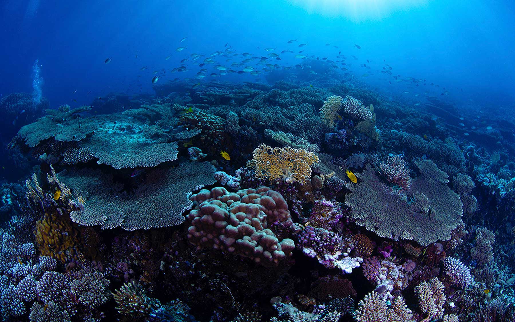
Coral reefs
The formation of coral reefs was the result of the emergence of most of the Red Sea islands from the remains of corals. This affirms that most of the Red Sea's islands are located on coral reefs, and are surrounded by reefs, barriers, and coral rings. This type of coral reef is widely spread in the Red Sea. It is submerged in tidal waters, and some of its formations appear during low tide. The proliferation of these reefs extends further south in the sea, showcasing a distinctive array of shapes, patterns, and colors in the Red Sea's coral formations.
The Red Sea stands out as the world's most abundant habitat for coral reefs, particularly as one moves away from cities, coastal communities, and the mouths of valleys. Within this sea are approximately 310 coral types, comprising 270 varieties of hard coral and 40 types of soft coral. Among these, the ciliate is particularly noteworthy, thriving especially near the two coasts due to the conducive environment for its growth and reproduction, the absence of rivers, limited rainfall, low tides, and moderate water temperatures.
Numerous conditions and factors have contributed to the distribution of coral reefs in the Red Sea. These include the expansion of the shallow continental shelf and the Red Sea's tropical location, characterized by elevated water temperatures, moderate salinity, and clear waters, coupled with abundant sunlight. These combined elements have created an optimal environment for coral proliferation and reproduction along the Red Sea, particularly along the coast. Exceptions are found in areas facing the mouths of valleys and regions affected by human and industrial activities along the coasts.
Coral reefs thrive abundantly in the Red Sea waters, particularly near the Gulf of Aqaba's entrance, positioned between Tiran and Sanafir islands and the coast. Along the Saudi coast north of the Red Sea, they concentrate near and along the coast to near al-Lith city, gradually proliferating and expanding westward in the sea to cover approximately 50 NM at its maximum reach into the sea, between the cities of al-Lith and al-Qunfudhah. Afterwards, the reefs continue to approach the coast, encircling islands until the southern end of the Saudi coast. Notable among the Kingdom's Red Sea reefs are al-Shaqa’eq, al-Bahm, al-Balad, Abu Shusha, al-Dark, al-Jadeer, Mubarak, Abu Sadin, al-Shu’ayba, al-Sabaa, al-Suflani, al-Khamsa, al-Qarsh, Nizar, Abu Modafe’, al-Kabir, al-Mismari, al-Shuja’a, Janabiyat, al-Jarm, and al-Dara.
The Arabian Gulf harbors approximately sixty coral species, exhibiting lower diversity and density in comparison to the Red Sea. Coral islands hold significant environmental value, serving as crucial breeding grounds for sea turtles in the Arabian Gulf. Additionally, these islands play a vital role for fishermen, as approximately 40 percent of the Gulf's total fisheries are comprised of coral reef fish.
The coral islands situated in the Arabian Gulf, including Kiran, Karin, Harqus, Jana, and Abu Ali, hold significant environmental value. These islands serve as crucial breeding grounds for sea turtles, terns, and Socotra cormorants in the region. Annually, during the mating season, these islands attract around one thousand turtles. Additionally, the coral reefs surrounding these islands are key mating sites for green turtles.
Vegetation cover in Saudi Arabia
The Kingdom exhibits a vast plant diversity across its diverse regions, providing suitable environments for a myriad of plant species. Approximately 2,100 plant species have been documented, including around thirty-five endemic species, constituting about 2 percent of the total plant species. Spatially, the distribution of plants is concentrated in the arid regions of the Kingdom, particularly in low-lying areas such as rawdat, valleys, and water courses where water accumulates after rainfall. Perennial plants, accounting for 35 to 40 percent of the desert species, are typically found in specific areas like the edges of rawdat, valleys, low depressions, and lands with sedimentation from floods and wind, characterized by deep soil. These plants also thrive in locations such as sand dunes and sabkha.
The Kingdom's plant diversity encompasses the development of savannah forests and grasses in the highlands of the south and southwest of the Arabian Peninsula, akin to those found in northeastern Africa. In the low desert areas of this region, plant species resembling savannah vegetation thrive, including acacia, acacia tortilis, vachellia flava, and various scattered tropical trees.
Soil
The soil composition in the Kingdom varies across different regions, with its characteristics closely tied to the surrounding environment. In general, the soil in the Kingdom is described as entisols or immature, lacking certain developmental properties. Natural factors such as an abundance of gravel, sand, and prominent rock blocks have contributed to diminishing the soil's suitability. The lands of the Kingdom are categorized based on their suitability for irrigated agriculture, and these classifications include:
Grade 1 lands.
Grade 2 lands.
Grade 3 lands.
Grade 4 lands.
Grade 5 lands.
Grade 6 lands.
Plant environments
Plant environments in the Kingdom vary according to the varied topography of different regions. Pastures account for roughly 73 percent, encompassing an estimated 146 million ha, whereas forests occupy an area of 2.7 million ha, constituting 1.35 percent of the area in the Kingdom. The number of natural plant species in the Kingdom is estimated at about 2,100, including between four hundred and five hundred species of perennial plants.
Plant environments in the Kingdom include the following sites and environments:
Valleys, floodwater streams, and rain drainage channels.
Aquatic environments (habitats): Submerged plants, floating plants, emergent plants.
Sand formations.
Coastal plain environment.
Coastal salt sabkhas environment.
Internal salt sabkhas environment.
Mangroves forest environment.
Gravel desert environment.
Al-Hamad Desert environment.
Desert plain environment.
Desert plateaus environment.
Mountainous region environment.
In the Kingdom, plants are categorized based on their natural environments into various types, including:
Mountain plants: Juniper, salam (vachellia flava), acacia, and sidr (Ziziphus spina-christi).
Valley plants: Acacia, vachellia tortilis, haloxylon, haloxylon persicum, and tamarisk.
Sand plants: Haloxylon, mugworts, tamarisk, and panicgrass.
Plants of the coastal plains and coasts: acacia and arak (Salvadora persica).
Plants of the internal and northern plateaus: haloxylon persicum, haloxylon, lycium shawii, rumex obtusifolius, and tamarisk.
The Kingdom's vegetation cover fosters conducive habitats for a variety of migratory birds known as summer visitors. The estimated count of migratory bird species in the Kingdom is around 260, categorized into three groups: breeding migratory birds, transient migratory birds, and non-breeding endemic migratory birds.
These bird species in the Kingdom include Philby's Partridge, which inhabits the southwestern highlands, in addition to the Arabian partridge, which inhabits the southwestern highlands, east of the Kingdom, Tihama, and center of the Kingdom. Other bird species include the Wheatears in the southern Arabian Peninsula, the Arabian waxbill, and the Arabian serin, which inhabit the southwestern highlands, Tihama, and the center of the Kingdom. The Arabian Accentor inhabits the southwestern highlands.
Pastures
A significant portion of the Kingdom's territory comprises expansive pasturelands, totaling 146 million ha, constituting 73 percent of the Kingdom's total area. Low density of plants and limited proportion of land coverage are evident there. Nevertheless, the pastures in the Kingdom exhibit notable diversity. Pastures in the Kingdom have been classified into two main types: pastures whose condition ranges from excellent (8 percent) to good (31 percent), and pastures whose condition ranges from poor to deteriorated (61 percent). Natural pastures in the Kingdom are characterized by their annual plants spread in large parts, and thus the production of these pastures is seasonal.
The percentage of excellent and good pastures in the Kingdom is decreasing, and this is due to two main factors. First, the impact of climatic conditions in the Kingdom, as rainfall is limited because the Kingdom is located in a dry tropical region. Second, the number of rainy days is also limited, ranging between fifteen and twenty-five days. The Kingdom's rain is irregular and generates fluctuating quantities. On the other hand, human factors are at play, including overgrazing, especially in the northern and eastern regions.
Pastures in the Kingdom have many geographical divisions, according to the diversity of their terrain, including:
Mountain pastures: Found in the Sarawat Mountains in Aseer, forming what could be called the southwestern pastoral region. This region has the best grazing areas in the Kingdom and is characterized by high average rainfall (two hundred mm - five hundred mm).
Desert pastures: Desert pastures are found in areas where the annual rainfall does not exceed 150 mm. These areas encompass the desert areas in Najd and the northern region, bordering the Kingdom with Iraq and Syria. Moreover, these pastures include the plains and valleys of the western range of the Kingdom, excluding the southwestern parts, especially in the Tihama Plain. Additionally, al-Ahsa region is also part of these pastures.
Saudi Arabia's climate
Due to the Kingdom's vast expanse and diverse topography, its climate exhibits variations from one region to another. Influenced by the tropical high pressure, the climate is characterized as continental, featuring hot summers and cold winters with rainfall occurring in the winter months. The western and southwestern highlands experience a moderate climate. In central regions, summers are hot and dry, while winters are cold and dry. Coastal areas witness elevated temperatures and humidity, with rainfall in the winter and spring. Most regions in the Kingdom experience limited rainfall, except for the southwestern highlands, which receive seasonal summer rains. Relative humidity remains higher on the coasts and western highlands throughout much of the year, decreasing as one moves further inland.
Spring unfolds in the Kingdom from mid-March to mid-June, displaying a relatively cool climate, particularly in the north where nighttime temperatures can dip below fifteen degrees Celsius. The central and southern regions, on the other hand, are marked by warmer conditions, with nighttime temperatures averaging around twenty degrees Celsius.
Summer in the Kingdom spans from mid-June to mid-September, except for the mountainous highlands in the Kingdom’s southwest, where temperatures remain moderate. This season commences with temperatures rising in most areas to approximately forty-five degrees Celsius. However, temperatures start to decline in the late night and early morning.
From mid-September to mid-December, the Kingdom experiences the fall season, characterized by a cool, refreshing breeze that sweeps across the northern borders and the southwestern highlands. Despite daytime warmth, temperatures occasionally reach around thirty degrees Celsius at the season's outset.
Winter spans the period from mid-December to mid-March in the Kingdom, characterized by chilly nights and average temperatures dropping below twenty degrees.
The commencement of winter, known as 'Merbeaaniyah,' spans forty days. This is succeeded by the Shabat season, lasting for twenty-six days. Following that, the Aqaarib season unfolds, circulating throughout the Kingdom for thirty-nine days. At the onset of the Aqaarib season, which signifies a shift to warmer weather towards its conclusion, an age-old proverb humorously mocks those who shed their heavy attire in favor of lighter clothing.
The Kingdom experiences winds throughout the year, influenced by its proximity to atmospheric pressure areas, including the high-pressure area over the Atlantic Ocean and the high and low-pressure areas in Central Asia. As a result, it is predominantly influenced by northeasterly winds for most of the year, northwesterly winds in winter, and monsoon winds in summer.
Climatic regions
The variety in terrain across the Kingdom’s expanse has led to multiple climatic regions. Despite being classified generally as a dry tropical climate, the detailed characteristics of the climate vary from one location to another. The Kingdom's astronomical position influences it, and it is impacted by three distinct climatic regions:
Tropical zone: It is limited to latitudes 16° and 18° N.
Desert zone: It stands as the most expansive and impactful, positioned within latitudes 18° and 30° N.
Temperate zone (Mediterranean): Confined between latitudes 30° and 32° N.
Several factors govern the spatial variations in the Kingdom's climate, including average minimum and maximum temperatures, atmospheric humidity, rainfall, and evaporation. As a result, eight climatic sub-regions have been categorized:
Climate of the eastern and western coasts.
Climate of Tihama in Aseer.
Climate of the highlands of the southwest of the Kingdom.
Climate of the southwestern plateaus (al-Taif and Najran).
Climate of Najd – al-Madinah.
Climate of Tabuk.
Climate of the center and north of the Kingdom.
Climate of the Empty Quarter.
Humidity and rainfall
Many coastal regions experience elevated levels of humidity and rainfall, showcasing notably high relative humidity, while inland areas exhibit significantly lower levels. This discrepancy can be attributed to factors, including:
The primary source of moisture is largely confined to the coastal regions.
Limited rainfall results in insufficient moisture in the air after evaporation.
Fragility and scarcity of vegetation.
These factors elucidate the fluctuation in relative humidity rates across different parts of the Kingdom, ranging from 35 percent in al-Khamasin to 70 percent in Jazan in December. Additionally, the variation spans from 14 percent in al-Khamasin to 68 percent in al-Wajh in July.
Rainfall in the Kingdom is influenced by various factors, including geographical location, proximity to water bodies, natural features, altitude, atmospheric pressure, winds, atmospheric low-pressure, air masses, their general characteristics, seasonal distribution of rainfall, and the actual amount of rainwater.
The Kingdom has two distinct rainfall patterns throughout the year. In winter, the northern and central regions receive precipitation as a result of the interaction between westerly winds (low-pressure systems advancing eastward from the Mediterranean Sea) and the extension of the Sudan low-pressure system. Conversely, in summer, the southwestern parts of the Kingdom witness rainfall due to the shift of the tropical confluence zone and the circulation of monsoon winds interacting with the region's topography.
Weather
The diverse topography in the Kingdom results in varying weather conditions across different regions throughout the seasons. Maximum temperatures across the Kingdom vary between twenty and thirty degrees Celsius in the winter (December to February), thirty to forty degrees Celsius in the spring (March to May), thirty-five to forty-five degrees Celsius in the summer (June to August), and twenty-five to thirty-five degrees Celsius in the fall (September to November).
The Kingdom experiences periods of heightened dust activity and dust storms originating from both internal sources, such as the Empty Quarter desert, ad-Dahna’ desert, and an-Nufud desert (an extension of the Syrian desert), and external sources, including the Iraqi desert, the Sahara Desert in North Africa, and the East African desert. This is commonly known as the dust season, extending from late June to mid-August.
Surface winds become active during the dust season, resulting in the elevation of sand over various regions of the Kingdom and a reduction in horizontal visibility. The dust season is attributed to the deepening of the Sudan low-pressure system, causing the lifting of dust, with some of it reaching the highlands of Jazan and Aseer provinces. At times, it extends to al-Bahah and Taif provinces. This coincides with vigorous wind movement along the Red Sea coasts, contributing to lifting dust on local coastal roads. In addition, dust is lifted on the southwestern coasts, including the governorates of al-Qunfudhah and al-Lith, reaching the coasts of Jazan Province, propelled by active monsoon winds.
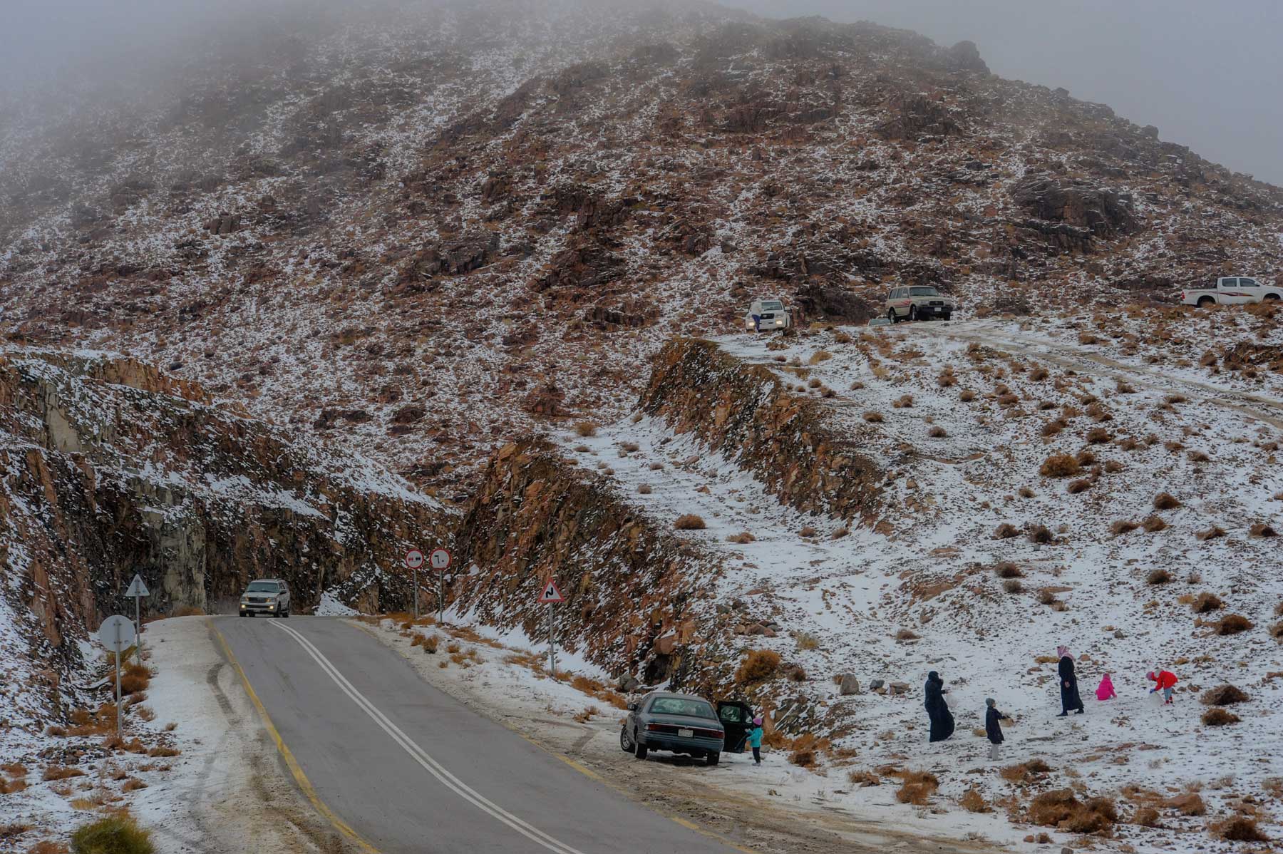
The snow season in the Kingdom marks one of the winter's manifestations. Snowfall occurs in specific regions, primarily in the northern and southern areas, with temperatures varying across different regions. The northern regions experience the lowest temperatures.
Snowfall is observed in several governorates and provinces of the Kingdom, including the Ballhamar, Ballasmar, and the city of Abha in Aseer Province. Large portions of the city of al-Bahah also witness snowfall. Additionally, snow occurs in the Turayf Governorate in the Northern Borders, and Tabuk's Jabal adh-Dhahr, Alaqan, and Jibal al-Lawz. Al-Qurayyat Governorate in al-Jawf Province experiences snowfall as well. Snow is recorded on Harrat ar-Ras al-Abyad in al-Madinah al-Munawwarah, Hazm al-Jalamid in the Northern Borders Province, and the city of Hail.
The snow season in Tabuk, northwest of the Kingdom, usually begins in January each year. Snow falls on some of the region's wilderness areas, mountains, and highlands, sending temperatures plummeting to zero degrees Celsius.
To stay abreast of weather conditions and ensure state-of-the-art equipment, the Sand and Dust Storm Warning Regional Center was inaugurated in Jeddah in 2023. Its primary goal is to safeguard the environment from natural hazards, monitor dust and sand occurrences, issue advance warnings about approaching storms, and implement all preventive measures to minimize their impact. The center's responsibilities include establishing a monitoring system for dust phenomena, conducting studies on climate phenomena and their repercussions, endorsing and enhancing national plans, addressing dust and sand occurrences, minimizing storm-related risks, and covering both national and regional levels.
Sources
General Authority for Statistics.
Ministry of Environment, Water, and Agriculture.
National Center for Meteorology.
Geography of the Kingdom, southwestern region of the Kingdom, Abdulrahman Sadiq al-Sharif, 1984.