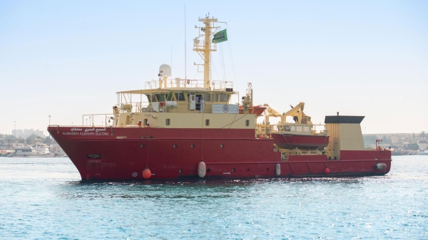
The Marine 'Hydrographic' Survey Project is implemented by the General Authority for Survey and Geospatial Information in the Kingdom of Saudi Arabia. The project aims to collect marine survey data for producing navigational charts, both paper and electronic, for the Red Sea, the Gulf of Aqaba, and the Arabian Gulf.
Importance of the Marine Survey Project
The importance of marine surveying is tied to development and economy, security and defense, scientific research, and the protection of the marine environment. This importance arises from the Kingdom's unique geographical location between the continents of Asia, Africa, and Europe. The Red Sea, the Gulf of Aqaba, and the Arabian Gulf hold strategic importance in connecting these continents and the rest of the world. This aligns with Saudi Vision 2030, which emphasizes making the Kingdom a hub connecting the three continents and optimizing the investment of its strategic location. Additionally, the Kingdom possesses vast resources of oil, gas, and minerals that are exported daily worldwide via ships passing through Saudi maritime areas. This necessitates the collection of marine data and the production of navigational charts and publications.
Objectives of the Marine Survey Project
The project aims to ensure the safety of marine navigation in accordance with the specifications and requirements of the International Hydrographic Organization 'IHO' and the International Maritime Organization 'IMO.' It also aims to produce coastal area maps and provide marine data to beneficiary entities.
Furthermore, the project aims to fulfill the requirements stipulated in the International Agreement for the Safety of Life at Sea 'SOLAS,' under the 'IHO,' of which the Kingdom, represented by the General Authority for Survey and Geospatial Information, is member number seventy-eight. The marine survey also aims to produce paper and electronic navigational charts and maritime publications that enhance the safety of marine navigation.
Stages of the Marine Survey Project
The project is implemented in three stages: The first stage includes the preparation of marine and aerial equipment and calibration of devices, completed after handing over the work site to the contractor. This stage includes preparing personnel to work on the project and obtaining the necessary permits and visas for working within the Kingdom.
The work in the second stage involves implementing the marine survey project, where data is delivered according to the division of the area to begin producing nautical charts. The project execution phase follows immediately after the first stage, and marine survey operations are conducted to measure depths, classify the seabed, and identify navigational obstacles using aircraft (LiDAR), echo sounders, and side-scan sonar devices. Additionally, marine vessels are used to cover gaps resulting from the lack of 'LiDAR' coverage to produce navigational charts. The third and final stage includes completing the marine survey project and delivering the project outputs and final reports.
Achievements of the Marine Survey Project
In 2024, as part of the marine survey project, the General Authority for Survey and Geospatial Information covered 100 percent of the Kingdom's maritime areas in the Red Sea and the Gulf of Aqaba with marine surveys, prepared marine databases, and produced paper and electronic nautical charts at various scales. Additionally, coastal zone management maps were produced for the planning and development of coastal areas and marine islands. The authority also produces and distributes several maritime publications to relevant entities. These include tidal current tables and tide tables, which are used by these entities for their work and activities.
The authority enhances marine survey operations by implementing projects in parts of the Kingdom's maritime areas in the Arabian Gulf, producing nautical charts and coastal zone management maps.
In 2023, the authority, in cooperation with the International Center for Electronic Navigational Charts, published forty-eight charts, including sixteen electronic navigational charts 'ENC.'
Role of the General Authority for Survey and Geospatial Information in the Marine Survey Project
The authority's role includes planning and executing marine survey and oceanographic activities in the Kingdom's maritime areas. This includes collecting, processing, analyzing, and storing marine survey information and data; training and capacity building of human resources; inventorying islands and their geographical names; setting standards and specifications for marine surveying work in the Kingdom; supervising marine scientific research related to marine surveying; and issuing permits for survey ships and scientific research vessels in maritime areas. Additionally, the authority is responsible for planning and executing marine survey projects using LiDAR-equipped aircraft and ships with echo sounders. It also manages marine survey data, produces both paper and electronic navigational charts, as well as coastal zone management maps, and oversees the national network of tide gauge stations.
The authority executes the marine survey project using the survey vessel 'al-Maseh al-Bahri Sultan,' which is equipped with modern devices, equipment, and software, and qualified human capabilities to collect survey data in deep marine areas. Its affiliated boats survey shallow marine areas, after which the data is processed and analyzed to produce various types of nautical charts.
Among the academic entities participating in the marine survey project is King Abdullah University for Science and Technology, which deployed two buoys to participate in the survey. King Abdulaziz University also participated with academic and training programs in the field of marine surveying.
World Hydrography Day
The General Authority for Survey and Geospatial Information, along with ministries, governmental authorities and centers, private sector entities, and academic institutions, celebrates World Hydrography Day on June 21 each year. Launched by the International Hydrographic Organization 'IHO,' the celebration highlights surveying activities in the Kingdom's maritime areas, raises awareness of its importance to individuals and society, and supports various vital activities at national and global levels.
Related quizzes
Related articles


