Saudi Mountains
Saudi Mountains represent the surface features and formations of the highlands in the Kingdom of Saudi Arabia. The highest mountain range in the Kingdom stretches from the western side, while plateaus cover the eastern part. The highest elevation of the mountains in the Kingdom reaches 3,015 m above sea level in the western part. Aseer Province is considered the highest part with nine mountain peaks, the highest of which is Jabal as-Sudah.
The mountain range extends to the west parallel to the coast of the Gulf of Aqaba and the Red Sea, starting from the northern border of the Kingdom with Jordan and reaching the southern Saudi-Yemeni borders. These are mountain ranges with a ladder-like shape, represented on their western fronts by rugged coastal slopes towards the Red Sea, gradually sloping eastward, reaching their peak elevation in the south with up to 3,015 m at the summit of Jabal as-Sudah, west of the city of Abha.
Mountains by geographical extent
The Western Highlands Mountains in Saudi Arabia
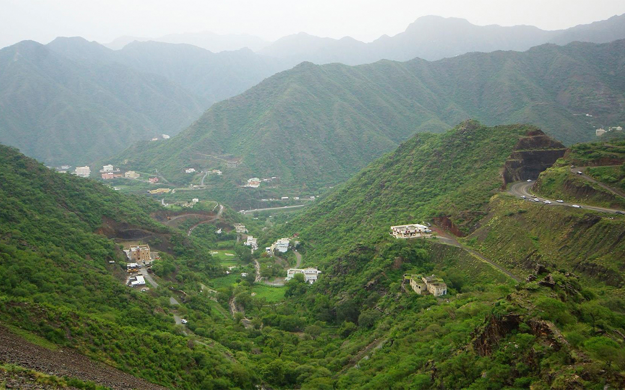
The western highlands can be divided geographically into three groups: the Sarawat Mountains, the Hijaz Mountains, and the Midian Mountains. The Sarawat Mountains represent the southern part of the western highlands and the most elevated and rugged portion, making it a destination for mountain climbers. They are separated from the Red Sea coast by the Tihama Plain, which includes smaller, homogeneous mountains in terms of elevation.
The western highlands extend from the borders of the Republic of Yemen to the north of the city of Taif, with elevations ranging from eight hundred to 3,015 m above sea level. Jabal as-Sudah, reaching an elevation of 3,015 m, is located within this range.
The Sarawat Mountains range consists of three main ranges: the coastal hills range, which begins as low hills gradually increasing in elevation towards the east, known as "al-Hubatah" convergence area. Then there's al-Asdar range, comprising the western slopes descending towards the west, from which several narrow valleys with steep and high sides originate. Lastly, there's the highlands range, starting from the watershed line where the valleys either head west towards Tihama or east towards the inner plains.
The Sarawat Mountains include the highest elevations in the Kingdom, such as as-Jabal as-Sudah, the highest at around 3,015 m, Jabal Ferwa' at 3,004 m, Jabal al-Majaz at 2,902 m, al-Sahla' at 2,837 m, Mana'a at 2,782 m, Mumah at 2,639 m, Katfa' at 2,623 m, Batharah at 2,604 m, Othrub at 2,447 m, al-Balas at 2,253 m, and Kara at 2,177 m.
From the Sarawat Mountains, valleys with steep slopes descend towards the Red Sea, including valleys such as Khulab, Jazan, Dammam, Baysh, Hali, Yaba, al-Ahsabah, and al-Lith. Some of their edges are covered by Harrat, which are basaltic plateaus found at the edges of some valleys, including Harrat like Nawasif, al-Birk, and al-Sarat.
In the Sarawat Mountains, the highest rates of biodiversity in the Kingdom's natural environments are found. The mountains are home to various types of forests, particularly juniper forests on their peaks. Other plant species such as acacia trees, wild olives, and some medicinal and aromatic herbs also grow in the area. Beekeeping is common in the region, and it is home to important national parks in Aseer, Taif, and al-Bahah.
The Hijaz Mountains represent the central part of the western highlands, starting from Taif Governorate westward until reaching al-Wajh Governorate to the north. They intersect at their end with the northern coastal plain of the Red Sea. Their western terrain is characterized by valleys descending towards the Red Sea. This mountain range is located in Makkah al-Mukarramah Province of the Kingdom, with its highest elevation reaching 2,393 m above sea level, represented by Jabal Wirqan.
The Hijaz Mountains encompass several elevations, including Jabal Wirqan, the highest at 2,393 m, Jabal Shamanasir at 1,618 m, Jabal Idqis at 2,161 m, Subh at 1,898 m, Jabal Awf at 2,082 m, al-Fiqrah at 1,901 m, and Radwa at 2,282 m.
The Hijaz Mountains are interspersed with numerous valleys (wadi) descending towards the Red Sea, including Wadi Fatimah, al-Safra, al-Hamd, and al-Abwa'. Basaltic plateaus, known as Harrat, cover some edges of these valleys. Among these Harrat are Khaybar, Rahat, ar-Raha, and 'Uwayrid.
The Midian Mountains are part of the mountain ranges in the Kingdom, stretching from the southern latitude of twenty-eight degrees northward to the borders with the Hashemite Kingdom of Jordan. They represent the northern section of the western highlands. The highest peaks reach an elevation of 2,549 m above sea level, with Jabal al-Lawz being the highest among them.
The Midian Mountains approach the shores of the Red Sea and the Gulf of Aqaba, sometimes bordering them in certain areas. The coastal plain disappears along its flanks, especially along the Gulf of Aqaba coast. Its mountains are formed by several complex elevations and high peaks.
The Midian Mountains encompass many highlands, including Jabal al-Lawz, its highest peak at 2,549 m, Jabal Zuhd at 1,980 m, ash-Shati at 2,103 m, Jabal Harb at 1,789 m, and ad-Dubbagh at 2,315 m.
A group of valleys flow from its mountains into the Gulf of Aqaba and the northern Red Sea, including the valleys of Mibrik, Umm Jurfin, Ifal, Aynounah, and Tirim.
Mountains in the center of Saudi Arabia
Jibal Aban al-Ahmar and Aban al-Asmar are located in Qassim Province, in the center of the Kingdom. The peaks of Aban al-Ahmar reach an elevation of 1,315 m above sea level, while the peaks of the Aban al-Asmar reach 1,243 m above sea level. They are considered the most important mountains in Qassim Province, totaling thirteen mountains.
Jibal Aban al-Ahmar are part of Jibal Abanat, which come in two groups of large and expansive mountains: Aban al-Ahmar and Aban al-Asmar. Jibal Aban al-Ahmar are located to the southwest of Aban al-Asmar, with the Northern Nufud al-'Urayq surrounding them from the west. Wadi Rumah separates them.
Jibal Abanat are composed of igneous and metamorphic rocks, from which several streams descend. Their vegetation cover is characterized by abundant date palm farms, and villages are distributed throughout the mountains.
Jibal Hasat Qahtan, located in Riyadh Province of the center of the Kingdom, specifically southwest of al-Quway'iyyah Governorate, are a group of mountains reaching an elevation of 1,508 m above sea level. They are part of the high plateau of Najd.
Jibal Hasat Qahtan are formed from a group of granite elevations distinguished by their reddish hue, with prominent peaks such as Batran and Dasas. Several villages are scattered throughout these mountains, which are traversed by a network of valleys and streams supporting dense vegetation. They are connected by a paved road branching off from the Riyadh-Taif highway, and Jibal Batran and Dasas can be seen to the east from the road leading to Hasat.
Mountains in the north of Saudi Arabia
The north of the Kingdom is home to a group of mountains, including Jibal al-Misma, located in Hail Province, specifically northwest of Bayda' Nithil. They reach an elevation of 1,431 m above sea level.
Jibal al-Misma consist of a group of continuous mountainous peaks extending from north to south on the borders between the provinces of Hail and Tabuk, bordered to the north and west by an-Nufud al-Kabir, and its length is about thirty km, and its width is about five km.
Jibal al-Misma include several mountains, including Jabal al-Sajnah in the north, with an elevation of about 1,013 m above sea level, and Jabal al-Arqoub in the south.
In Hail Province, there is Jabal Abu Rawadif, one of the volcanic mountains in the Kingdom. It reaches an elevation of 1,141 m above sea level.
Jabal Abu Rawadif comprises four small peaks, and due to its shape, the mountain was named 'Abu Ruwadif'.
Jabal Abu Rawadif is confined between several mountains, including Jabal al-Qarnayn from the north, Sinaf al-Makhruqah from the south, al-Ghiraybat Mountains from the east, and Qa’ al-Hilali from the west.
Jabal ash-Shiyati is one of the mountains in the north of the Kingdom, located in the Tabuk Province northeast of the village of al-Kharibah. It reaches an elevation of 2,103 m above sea level. It is part of the Midian Mountains, which extend from south of the twenty-eighth latitude north to the borders with the Hashemite Kingdom of Jordan. Additionally, there is Jabal Yatib in Hail Province, specifically thirty km east of Hail City. It hosts archaeological sites dating back to the third millennium BCE, including a collection of Thamudic rock art and inscriptions.
Jabal Yatib is surrounded by desert dunes and contains several Thamudic inscriptions and rock art. Its artistic elements consist of depictions of humans, camels, lions, and palm trees. It is considered one of the tourist attractions in Hail Province.
Mountains in the south of Saudi Arabia
Jabal Fayfa is located in Jazan Province, within the mountains of the south of the Kingdom, specifically east of Sabya Governorate. It is approximately one hundred km away from the city of Jazan, the administrative capital of the province. With an elevation of 1,814 m above sea level, it is part of Jibal Sarawat, which stretch from the north of Taif City to the Saudi-Yemeni border in the south.
Jabal Fayfa is surrounded by Wadi Damad from the east to the west, and by Wadi Jura from the north to the west, forming its boundaries in an arc shape. These two valleys meet in an area known as "al-Mahah" west of the mountain. The mountain consists of a range of peaks varying in elevation, with one of the most famous being the summit of al-Abassiyah. Several valleys descend from it, including Wadi al-Fur', Wadi Dhubub, and Wadi al-Muhr.
Jabal Fayfa is considered a rugged mountainous area and is included in the list of the highest and most complex mountains in the Kingdom in terms of elevation and terrain ruggedness.
Jabal al-Hashr is located in Jazan Province, specifically northwest of ad-Da'ir Governorate. The highest peaks of Jabal al-Hashr reach an elevation of 2,307 m above sea level. It is part of the Sarawat Mountains, which extend from the border with the Republic of Yemen to the north of Taif city.
Jabal al-Hashr is considered one of the tallest mountains in the Kingdom in terms of elevation and is a prominent tourist attraction in Jazan Province. It is composed of rocks known for their solidity and resistance to erosion processes. Its vegetation cover consists of diverse trees such as acacia, tamarisk, and wild olive trees. The seasonal rainfall contributes to expanding green pasture areas and the growth of some aromatic plant species.
There is also Jabal al-Arif in Jazan Province, northeast of Fayfa Governorate. It reaches an elevation of 2,632 m above sea level and is part of the Tihama highlands in the Sarawat Mountains, stretching from the border with the Republic of Yemen to the north of Taif City.
Mountains in east of Saudi Arabia
Jabal Qarah is considered one of the landmarks of the Eastern Province, specifically in the city of al-Hufuf in al-Ahsa Governorate. It is located approximately fifteen km away from the city amidst the green oasis. It stands at an elevation of 210 m above sea level and stretches for about one thousand m. It is the second smallest mountain in the kingdom after Jabal Abraq al-Kabrit.
The formation of Jabal Qarah dates back to over 2.5 million years ago. It is surrounded by four historical villages: Al-Tawthir, al-Dalwah, al-Tahimiyyah, and the village of al-Qarah, from which the mountain takes its name. It overlooks vast areas of palm groves, orchards, and villages.
Jabal Qarah is formed from layered limestone with colorful strata exposed by erosion factors. Its summit is comprised of a massive rocky hill known as al-Mashiqir. The mountain's peak has an ancient history dating back to pre-Islamic times, as it was once a residence for the kings of Kindah and is mentioned in the poetry of Imru' Al-Qais.
Jabal Qarah is considered one of the tourist attractions in al-Ahsa Province. It can be accessed through several routes, including the road that passes through Ain al-Khudud, al-Jishah road, or al-Jafr Road passing through al-Shahareen and al-Mansoura.

Prominent mountains in Saudi culture
Tuwayq Mountain
The Tuwayq Mountains, also known as Jabal Tuwayq, Jabal al-Aridh, or Aridh al-Yamama, are among the most important geographical and tourist landmarks in the Kingdom. This mountain range forms a narrow plateau located in the heart of Najd, west of Riyadh Province, and in the central part of the Kingdom.
The Tuwayq Mountains stretch for eight hundred km, penetrating Nufud ath-Thuwayrat of Qassim Province, passing through the borders of Wadi ad-Dawasir in Riyadh Province, and reaching the outskirts of the Empty Quarter Desert in the south of the Kingdom.
The elevation of the Tuwayq Mountains above the surrounding plains reaches up to 250 m. However, the summit known as "Fareeda al-Shazia," located northwest of the city of al-Hariq in Riyadh Province, stands as the highest peak on the edge of Tuwayq, with an elevation of 1,196 m.
The mountain range was called Tuwayq, a diminutive version of Tawq (ring/circle in Arabic) because its peaks take the shape of a ring. Human settlements spread on its outskirts, dating back to prehistoric times and stone-paved roads passed through it. Caravans crossed through it in the past for pilgrimage and trade.
The Tuwayq Mountains can be seen from outer space and are composed of limestone rocks formed since the Jurassic period, with sedimentary edges and coral heads, indicating a history dating back five hundred million years when the area was covered by water. They are characterized by steep rocky cliffs, gradually sloping from the east and abruptly ending to the west. Their width in the central section is approximately twenty km, while the northern and southern edges are around ten km wide.
Tuwayq Mountains occupy an important place in Saudi memory. In 1818, on its slopes, the Saudi army fought the invading Ottoman forces led by Ibrahim Pasha during their invasion of Diriyah, the capital of the First Saudi State.
In addition to its historical significance, the Tuwayq Mountains have occupied a space in both ancient and contemporary poetry. They were referenced by the Saudi Crown Prince, Mohammed Bin Salman Al Saud, in his speech during the Future Investment Initiative conference in Riyadh in 2018, where he said, "The Saudis' strength is like that of the Tuwayq Mountains."
The Tuwayq Mountains symbolize the official icon for the Qiddiya project, one of the largest entertainment, sports, and cultural projects within the Saudi Vision 2030. On one of its slopes, located fifty km away from the capital Riyadh, lies the Qiddiya project center, where the mountain reaches an elevation of six hundred m in the project area.
Visitors and tourists often explore the edges and slopes of the Tuwayq Mountains through climbing tours or off-road vehicle excursions, or by hiking on foot, aiming to reach one of its famous edges known as the "Edge of the World."
Aja Mountains
It is a mountain range located west of Hail Province in the Kingdom, with Aja being its largest peak, rising about five hundred m above the administrative capital of the province, the city of Hail. It is also the highest peak of the Najd Plateau, reaching an elevation of 1,544 m above sea level.
Jibal Aja are formed from granite rocks and include several mountain peaks, such as Jabal Mashar in the east, Jibal Sahabin in the southwest, Jabal Sawa in the center, Jabal Haloun in the west, and Jabal al-Ra'ila in the north.
The area contains a group of surface water wells, traversed by Sha'ib Jaw and Sha'ib Tawarn from the north, Sha'ib Naylat from the west, and to the south by Sha'ib al-Bar and al-Sir. To the northeast, it is crossed by Sha'ib Nuqbin.
Salma Mountains
It is a mountain range in the Kingdom, located southeast of Hail Province, with its highest elevation reaching 1,430 m above sea level.
Jibal Salma are composed of granite rocks, with their boundaries stretching from the northeastern part of Hail City to its southwestern part. They extend for about sixty km in length and have a width of approximately thirteen km.

Al-Lawz Mountains
It is a mountain range in the Kingdom, located in Tabuk Province, within the geographic boundaries of the city of NEOM. It represents the highest peaks, with an elevation of 2,549 m above sea level. It is the only place in the Kingdom where snowfall occurs almost every year.
These mountains are named Jibal al-Lawz due to the abundant growth of wild almond trees on their peaks.
Jibal al-Lawz are considered a prominent tourist destination in Tabuk Province and the Kingdom as a whole. During winter, snow covers their high peaks, making them a prominent tourist destination for hiking and adventure enthusiasts.
During the winter season, several tourist activities are organized in the mountain area where people can drive a car along the mountain roads, go hiking in the snow, in addition to riding camels during winter tours.
Evidence of several ancient civilizations has been recorded in Jibal al-Lawz, represented by some rock drawings dating back to around ten thousand years BC. These include ancient engravings as well as Arabic inscriptions from the post-Islamic era.
From Jibal al-Lawz, several peaks branch out, with the highest being Jabal Fayhan. These mountains are composed of granite rocks surrounded by sand in most parts. They give rise to a series of valleys and streams, including Wadi Afal from the west, Wadi Rayt from the south, and Wadi al-Abyad from the north.
Jibal al-Lawz are specifically located northeast of al-Bad' Governorate, approximately two hundred km northwest of the administrative capital, the city of Tabuk. They are bordered by the Tabuk-Haql Road to the north and the Sharaf-al-Bad' Road to the west. They constitute the highest peak in the Midian Mountains range, which extends from south of the twenty-eighth latitude north to the border with the Hashemite Kingdom of Jordan.
Prominent mountains in Islamic culture
Uhud Mountain
One of the most famous mountains in al-Madinah al-Munawwarah, it represents a historical and geographical landmark. It was the site of the Battle of Uhud at the beginning of Islam between the Muslims and the Quraysh. It embraced seventy martyrs from Sahabah (Companions), led by the uncle of Prophet Muhammad, peace be upon him (PBUH), Hamza Ibn Abdul-Muttalib, known in Islam as the Chief of Martyrs.
Three narratives exist regarding the naming of Uhud. The first suggests it was named for its unique terrain, distinct from other mountains, surrounded by plains and valleys. The second narrative proposes it was named after a giant named Uhud, the first to inhabit it. According to the third narrative, it was named to symbolize the oneness of Allah.
Uhud includes historical inscriptions bearing some expressions of majesty, dating back over five centuries. It is surrounded by remnants carrying features of the prophetic era, including the Mosque of Fasah, where the Prophet Muhammad prayed Dhuhr and Asr prayers during the Battle of Uhud, and Jabal al-Rumat (Mount of Archers), which some Muslims used as a place to shoot their arrows during the battle. Additionally, there is a valley named after the follower of the king of Yemen, with its water source from Wadi Waj in Taif Governorate.
The mountain rises over a thousand m above sea level, with more than eight types of plants growing on it. It contains volcanic and igneous rocks of various colors, some dating back to the Cretaceous period. The mountain has natural cavities that store rainwater, preserving it until the next rainy season.
Jabal Uhud forms a range of interconnected mountains with multiple peaks and streams, stretching over eight km in length and two km in width on its eastern side, while on its western side, it extends over more than three km. It is located north of al-Madinah al-Munawwarah, five km from the Prophet's Mosque, with its highest point about 1,077 m above sea level.
The mountain contains several natural depressions, called al-Maharis (singular: Mehras). These serve as natural reservoirs that retain rainwater for most of the year. They are located in Sha'ib Jarar, known as Sha'ib Haroon, at ground level. The water in these maharis is pure and deep during the rainy season, gradually changing in color and taste but not disappearing until the rains of the following year.
Surrounding Jabal Uhud, there is a small mosque on the side leading to the Mehras, which has been connected to urban development and now lies amidst several residential houses, most of which have been demolished, leaving only a few remnants. It has been fenced off by the Municipality of al-Madinah. Additionally, there is Jabal al-Rumat and Wadi Qanat, named after the Yemeni follower who passed by it and said, "This is the channel of the earth." The source of the valley's flood is a canal from Wadi Waj in Taif.
Al-Nour Mountain
Jabal al-Nour is located in Makkah al-Mukarramah Province, specifically northeast of the Grand Mosque. It is situated just four km away. At its summit lies the Cave of Hira, one of the most significant historical and Islamic sites, being the place where the first revelation descended upon Prophet Muhammad (PBUH). It is from here that the call to Islam began, marking the culmination of divine religions and messages. It was here that the first verse of the Quran was revealed: "Read in the name of your Lord who created."
The mountain has several names, including Jabal al-Quran, Jabal al-Islam, and Jabal Hira. However, the most famous name is Jabal al-Nour, which means the "Mountain of Light," referring to the divine lights of Prophethood that emerged from it. From its summit, one can view the city of Makkah al-Mukarramah, as it stands at an elevation of 642 m above sea level. Its area spans 5,250 m².
The executive committee of the Islamic Historical Sites and Museums Path, affiliated with the Pilgrim Experience Program and under the supervision of the Royal Commission for Makkah City and the Holy Sites, has undertaken several development projects for Jabal al-Nour. These projects aim to educate visitors about the accurate historical information regarding the mountain and to facilitate access to it.
Among the works of the Executive Committee of the Historical Sites Path is the establishment of Jabal al-Nour Cultural Center, located over 67,000 m². It includes the Revelation Exhibition, which tells the story of the revelation using the latest technologies, the Visitor Center, the Holy Quran Museum, the cultural gallery, the way of ascending to the cave, and several other facilities.
The committee also worked on the project of improving the pathway to the caves of Hira and Thawr, enhancing accessibility while providing necessary services and reinforcing security and safety measures for visitors.

Geography of mountains in the Kingdom
Volcanic mountains
In the Kingdom, there are various volcanic mountains, including Jabal Layla, located southwest of Harrat al-Harrah between the provinces of al-Jawf and the Northern Borders, specifically northeast of Tabarjal Governorate. It is considered one of the smaller mountains in the Kingdom, with an elevation of 897 m above sea level.
Jabal Layla is known to be a volcanic cone, featuring a volcanic crater at its summit. To the north, it is surrounded by Qi'an (Basins) Laila, while volcanic lava flows extend from the other directions. Previously, Harrat al-Harrah was known as Harrat Layla, and it was named "Jabal Layla" after it.
Jabal Layla is bordered by Jabal al-Mataha to the north, Jabal Abu Sleilat to the south, and Jabal Um Zuwair and the Dusum hills to the west.
Among the volcanic mountains is Jabal Butaylah, situated in Makkah al-Mukarramah Province, specifically at the northern edge of Harrat Hadan, northwest of the villages of al-Hafira and al-Khalidiya. Jabal Butaylah is a volcanic cone with an elevation of 1,214 m above sea level.
Jabal Butaylah is one of the geological landmarks of Harrat Hadan, which is one of the oldest volcanic fields in the Kingdom. Located within Makkah al-Mukarramah Province, the mountain represents a distinct volcanic cone separate from the structure of Harrat Hadan. Its summit contains a volcanic crater, and it stands out as one of the more recent volcanoes in Harrat Hadan, evident in its clearly defined mountainous features.
Jabal Butaylah is situated amidst several geographical landmarks. To the north lie Jabal al-Ashfyan and Qarat Shidad, while to the south is Harrat Hadan. To the east, it is bordered by the course of Wadi al-Buraym, and to the west by the tributary valley of Wadi Salbah.
Mount Athmor is a range of volcanic mountains in the Kingdom, located in al-Madinah al-Munawwarah Province. Specifically, it is situated near the northern outskirts of Harrat Khaybar, east of the city of Khaybar, and to the west of the center of al-Huait. It is also northeast of the center of al-Thamad. Jabal Uthmor is a geological landmark of Harrat Khaybar and hosts some of its newest volcanoes. The highest peak in the range reaches an elevation of 1,882 m above sea level.
Jabal Uthmor includes the Uthmor Cave on its northern side, which is a volcanic tube channel extending as a tunnel inside the mountain. The cave consists of a wide opening, with its southern end serving as the entrance. It stretches approximately seven hundred m in length, descending steeply into the earth's interior. At its center lies a pit resembling a deep hole.
Jabal Uthmor is comprised of a group of volcanic cones and craters, with steep, dark volcanic rocks descending from its western edges, indicating recent volcanic activity. It is bordered by several mountain ranges, including Jabal al-Qadeer to the north, Jabal al-Qadr to the south, Jabal al-Murtazah to the east, and Jibal Mazbah al-Rikab and al-Marzouqiyah to the west. Accessible via a paved road encircling it from the south, it is separated from Jabal al-Qadr, which traverses Harrat Khaybar, connecting the western Thamad center to the east with the city of al-Ha'it.
Jabal al-Jafdarah, also known as Harrat al-Wabra, is one of the volcanic mountains in the Kingdom. It is located in al-Madinah al-Munawwarah Province, to be specific, it is to the north of the route of the oil pipelines connecting the Buqayq and Yanbu governorates, to the east of `Ushayrah village. The mountain rises 1,241 m above sea level and stands as a geological landmark of Harrat Rahat, the largest volcanic field in the Kingdom. Administratively, it falls within the territories of both Makkah al-Mukarramah and al-Madinah al-Munawwarah provinces. It is part of the Hijaz Mountains, stretching from Taif Governorate in Makkah al-Mukarramah Province to al-Wajh Governorate in Tabuk Province to the north. The mountain is surrounded by several others, including Jabal As-Sammak to the north, Jabal Um Rayah to the southeast, and Jabal ad-Dhayyabah and Um Safa to the west. It is bordered by Halat Muslimah to the south and Halat al-Yas to the east.
Jabal al-Jafdarah contains two volcanic craters, one to the north of the mountain’s peak and is four hundred m in diameter and twenty-five m deep, while the other is to the south of the peak and is about ten m deep.
Among the volcanic mountains in the Kingdom is Jabal Kudumbal or Kutumbal, located in Aseer Province within the waters of the Red Sea, on the western edge of a volcanic island. It is about three km away from the coast. This mountain is a volcanic cone, with an elevation of fifty-two m above sea level. It is one of the geological landmarks of the Barkah Plateau, located in the coastal Tihama plain. The Harrat takes the form of a semi-flat and elevated plateau above sea level.
Jabal Kudumbal is specifically located on an island along the coast of Aseer Province. This island is one of several belonging to the Qahmah Center. The eastern half of the island consists of sandy plains, while sands surround the mountain from three sides. Visitors can reach the island by fishing boats. Activities such as swimming and diving are practiced on the island, which covers an area of approximately three km². It is a favored destination for enthusiasts of falconry, as migratory falcons often settle on the summit of Jabal Kudumbal after migrating from the African continent.
Jabal Raqa'a, one of the volcanic mountains in the Aseer Province, is situated southwest of Harrat al-Birk on the coast of the Red Sea, between al-Qahmah center to the north and al-Huraydah to the south. It is a coastal volcanic mountain with an elevation of seventy-eight m above sea level. It is bounded by the coastal road that connects Jazan Province and Jeddah Governorate to the east, and the Red Sea coast to the west, with Jabal al-Raqba to the southeast. To its east are Jibal al-Abalal and al-Zour.
Jabal Raqa'a is considered one of the geological landmarks at Harrat al-Birk in the Tihama coastal plain southwest of the Kingdom, which is administratively within the land of Aseer Province. Harrat al-Birk is a plateau above sea level dating back to about two million years ago.
Jabal Raqa'a consists of various rocks, such as zeolite and black scoria. The zeolite rock is utilized by adding it to cement, which makes it more resistant to salinity and erosion. On the other hand, black scoria rock can be utilized in construction work as lightweight concrete.
Jabal al-Aqir is one of the volcanic mountains in the Kingdom, located in al-Madinah al-Munawwarah Province, specifically near the northern outskirts of Harrat Khaybar, southeast of the city of Khaybar. It is a volcanic dome with an elevation of 1,943 m above sea level and is considered one of the geological landmarks of Harrat Khaybar.
Jabal al-Aqir is confined among several mountains, including Jabal al-Abyad from the north, from the south mountains: Al-Ahmoum, Halyat al-Mazra’at, and Halyat al-Mansaf, in addition to Jabal al-Bayda from the northwest, from the east Jibal Halat Umm al-Ghiran and Umm Kharqa from the west.
Jabal al-Aqir, along with its neighboring mountains, represents a water division area, where some of the upper reaches of Wadi Rumah descend towards the east, and a group of upper reaches of Wadi Khaybar descend from it towards the west. One of the main tributaries of Wadi al-Hamd. The mountain is surrounded from the east by the course of Sha'ib al-Dahu.
Jabal al-Aqir is a group of volcanic cones, the focus and center of Harrat Khaybar, as it includes a group of cones and volcanic heights that differ in terms of shapes, types, ages, and colors.

Distinctive Saudi mountains
Al-Fil Mountain (Elephant Mountain)
Jabal al-Fil, one of the mountains in the Kingdom, appears in the form of a rock mass resembling an elephant. It is located in al-Ula Governorate in al-Madinah al-Munawwarah Province, east of the archaeological site of al-Hijr, approximately twenty km away from the governorate.
Jabal al-Fil is composed of red sandstone. Over millions of years, erosion and weathering have sculpted its shape to resemble an elephant with its trunk reaching the ground, hence its name. Surrounding the mountain are deposits of desert sand. It is considered one of the geological wonders of al-Ula and a prominent tourist attraction.
A mountain containing twelve caves east of the Kingdom
Jabal Qarah, located in al-Hufuf City in al-Ahsa Governorate, contains twelve caves known for their varying temperatures throughout the year. These caves come in different shapes and sizes. Among them is al-Naqah Cave, which can accommodate about four hundred people, making it the largest and most spacious. There's also al-Eid Cave, situated near the Sunday Market, along with the Mahyoub Cave, Maghara Cave, and the Bousaleh Cave.
One of the highest mountains of Sarawat
Jabal As-Sudah: It is one of the mountains in the Kingdom and the highest peak. It is located in Aseer Province, specifically east of al-Harjah Governorate. It reaches an elevation of 3,015 m above sea level. It is part of the Sarawat Mountains, which extends from the north of Taif City to the Saudi-Yemeni border in the south.
Jabal Natfah: It rises to approximately 2,971 m in elevation and is located in al-Harajah Governorate in Aseer Province, within the Sarawat Mountains that stretch from the border with the Republic of Yemen to the north of the city of Taif.
Jabal al-Majaz: It is one of the mountains in the Kingdom and the third highest peak, located in Aseer Province, specifically southeast of Sarrat Abidah, with an elevation of 2,902 m above sea level. It is part of the Sarawat Mountains, which extends from the north of Taif City to the Saudi-Yemeni border in the south.
Jabal Mawma: Located in Aseer Province, specifically northwest of the Tanomah Governorate, it stands at an elevation of 2,639 m above sea level. It is part of the Sarawat Mountains, which stretch from the border with the Republic of Yemen to the north of Taif city.
Jabal Katfa: It is one of the mountains of the Kingdom, located in Aseer Province, west of al-Jawah Center of Sarrat Abidah. It is 2,623 m above sea level and located within the Sarawat Mountains that extend from the border with the Republic of Yemen to the north of Taif City.
Jabal Atherb: Located in al-Bahah Province, specifically southeast of the Baljurashi Governorate, with an elevation of 2,447 m above sea level. It is part of the Sarawat Mountains stretching from the border with the Republic of Yemen to the north of the city of Taif.
Jabal Kara: It is one of the mountains in the Kingdom, located in Makkah al-Mukarramah Province, southwest of Taif Governorate. It stands at an elevation of 2,177 m above sea level and is part of the Sarawat Mountains, which extend from the border with the Republic of Yemen to the north of Taif City.
The role of the Saudi government in caring for mountain environments
Mountains in the Kingdom fall within the purview of the Ministry of Environment, Water, and Agriculture, which works on caring for mountain environments through several tasks, including preserving the ecological systems and biodiversity of mountains, activating various programs and events to raise awareness about the importance of environmental conservation, enacting laws to limit deforestation and poaching, and fostering community participation among individuals and sectors.