Rock Art in Hail Province
The phenomenon of rock art has emerged throughout human history, being the oldest human artifacts, found on mountain outcrops, caves, or rocky surfaces. These were found in places that were considered ancient human settlements. Among these is the rock art in Hail Province of the Kingdom of Saudi Arabia, which has been a global historical site since the nineteenth century. The arab ancestors left traces of their human experiences through drawings representing human and animal figures. It was registered on the UNESCO World Heritage List in 2015, making it the fourth saudi archaeological site listed after Hegra, Diriyah, and the Historic Jeddah.
Rock art in the Hail Province, and other parts of the Kingdom, has played a significant role in highlighting the cultural depth of the Kingdom. The Kingdom ranks as the fourth-richest region in rock art globally, following Australia, Africa, and India. It boasts a vast and rich cultural heritage of diverse rock art that is spread across various topographical environments. this art spans from the Neolithic period (New Stone Age) to the Islamic era.
History of rock art in Hail
The early human settlements and habitation in the Hail Province have led to the emergence of numerous archaeological sites indicating the successive civilizations there. Among the most prominent of these archaeological sites is the rock art consisting of inscriptions, imprints, and drawings. This is one of the Kingdom's most significant ancient cultural landmarks, which is considered one of the richest civilizations in the ancient near east with this type of art, possessing over one thousand four hundred rock art sites and hundreds of thousands of human and animal figures.
Hail Province provided an environment conducive to settlement. It witnessed alternating climatic roles and conditions ranging between arid and rainy. In the recent phases of the Pleistocene era (three million – ten thousand years BC), rainy periods prevailed, leading to the widespread growth of vegetation, while other phases saw the formation of deserts and the drying up of lakes. With the onset of the Holocene era (starting ten thousand years BC), the climate changed to rainy, with increased rainfall, valley flow, and vegetation cover. During five thousand years BC, the last drought period began and continues to this day.
These shifts led to the emergence of several civilizations over the ages, leaving their imprints on the region. On the slopes and highlands, stone tools dating back to the Old Stone Age (Mousterian) have been found, dating between one hundred twenty thousand and forty thousand years ago. Additionally, two sites from the same period were discovered in al-Nefud al-Kebir desert in Jebbah, near Umm Sinman mountain. These sites include a number of double-edged scrapers and disk-shaped tools. Various scattered sites in the region have also been found that date back to the New Stone Age. The stone tools from this era consisted of pieces of chert, blades, scrapers, disk-shaped stones, and many serrated and notched pieces.
Nature of the Rock Art
There are many types of rock art found in the Kingdom and they express different styles of life and communication between successive civilizations. These, including engravings, imprints, and drawings, are among the most important landmarks of the ancient civilization of the Kingdom. Most of the rock art, including hundreds of thousands of human and animal figures, were found in the north and northwest of the Kingdom, in al-Jouf, Sakaka, Tabuk, Tayma, Kulwa, Hail, Jebbah, al-Shuwaymis, Hegra, al-Ula, al-Madinah al-Munawwarah, al-Hanakiya. And in the south and southwest of the Kingdom, in Taif, al-Bahah, Aseer , Abha, Najran, Hima, and Jazan. In addition to some areas in the central region of the Kingdom, like al-Quwaiiyah, al-Duwadimi, and Riyadh.
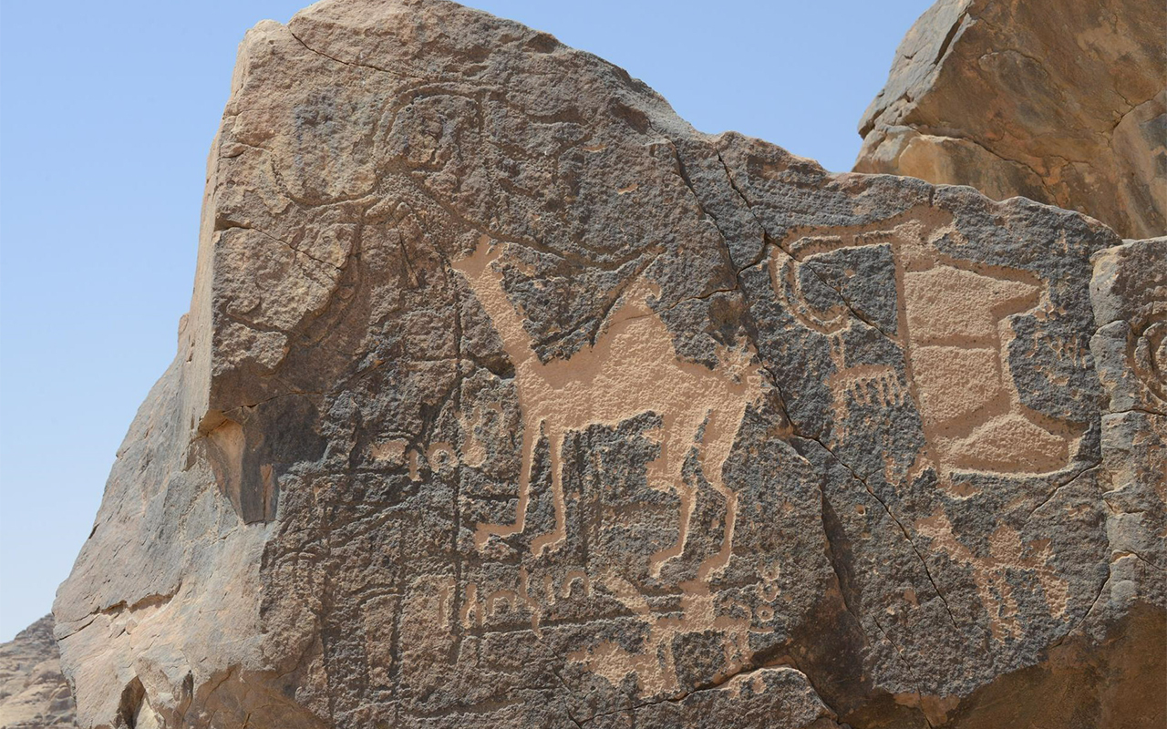
The rock art discovered in the Kingdom showcase various forms and engraving methods. In al-Sulayhat mountain in Jubbah, al-Markabah mountain, al-Shuwaymis, Subhah, more numerous depictions of human palms were found. These include engravings of the palm pattern alone, the palm with the forearm, the palm with the forearm, and a part of the elbow and upper arm, or the entire arm. In addition to some archaic human figures, domesticated animals like camels, and some thamudic letters are also depicted.
Jubbah (ninety km north of the city of Hail) is one of the most famous rock art sites in the Kingdom. It is an oasis with remnants of an ancient lake that was once rich in vegetation, wildlife, and human habitation. Now, it is surrounded by a sea of shifting sands in al-Nefud Desert. Unlike paintings and engravings from the New Stone Age found in other parts of the world, the rock art in Jubbah is characterized by deep carvings. These display very prominent images that still retain their original features significantly. The engravings depict images of men and women, providing insight into the clothing people wore in the past and how they styled their hair. These artistic relics also display animals, hunting scenes, and weapons such as bows, arrows, sticks, and spears.
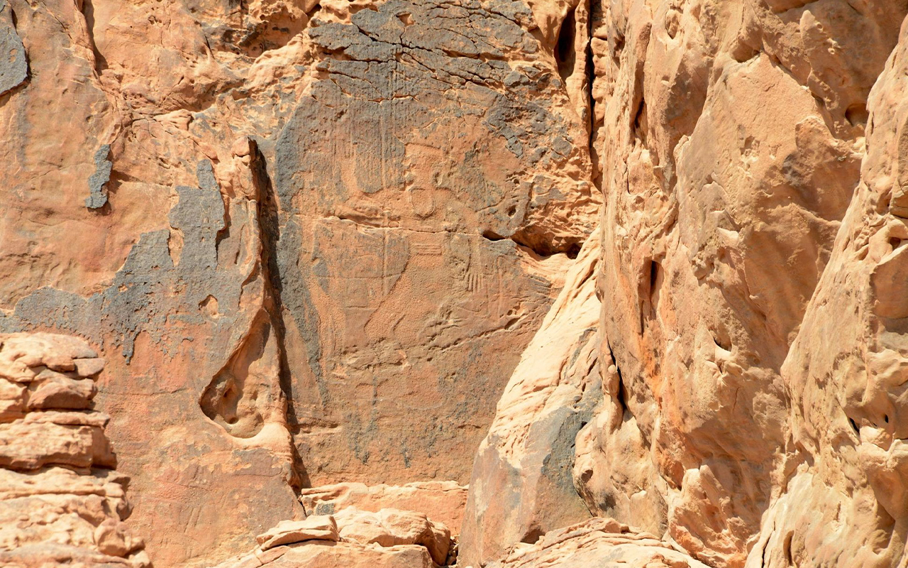
The rock art in Jubbah bears similarities to that found in North Africa, in countries like Algeria, Libya, and Egypt. Jubbah hosts two of the most symbolic carvings in the Kingdom. The first depicts a man in a position of authority, dressed in the attire and jewelry of nobility, appearing dominant over his subjects, which may be interpreted as one of the ancient kings. The second displays a chariot pulled by two horses.
Jubbah is distinguished by passing through three different eras: the modern era, the Thamudic era, and the late prehistoric period. Thus, its rock art does not belong to one era or one civilization. The modern rock engravings consist of mysterious Arabic inscriptions carved with a metal object. However, some of the Arabic engravings are undated and were inscribed using another stone, indicating they date back to earlier times. Images of camel riders can be observed, as well as scenes of battles with people using spears to fight on horseback.
Rock Art throughout history
Hail Province has been associated with rock art for ancient eras and epochs, reflecting the memory of the societies that lived there. Two desert sites renowned for rock art are Umm Sinman mountain (Jubbah) and the mountains of al-Al Manjoura nd Ratta (al-Shuwaymis). The ancestors of the current Arab population groups left traces of their settlement, including many rock engraving panels, in addition to numerous other carvings. These artifacts represent a vast number of human and animal figures, dating back up to ten thousand years.
The rock paintings and engravings spread across several sites in the Hail Province are cultural manifestations through which the inhabitants of that region, throughout prehistoric times and historical eras, expressed their daily livelihoods, religious practices, interactions with the environment, and daily life. Most of these date back to the Prehistoric period or the late stone age (fourteen thousand years before the present era). They represent various types of animals that humans either used or hunted, such as wild cattle, ibexes, deer, ostriches, and mountain goats.
The diversity of rock art in Hail also includes abstract images of adjacent human figures, depicting communal celebrations, religious practices, war battles, and dual duels. They vividly express rhythm and movement in hunting practices, and images of predatory animals, such as lions and leopards. There are also drawings dating back to the early Islamic period, and inscriptions in Kufic script, some of which are dated to the eighth century.
Types of rock art in Hail
The rock art in Hail Province varied according to the communicative purposes of the civilizational groups that settled in the area. during the prehistoric era, the style of rock engravings was limited by the engravers' skills and the difficulty of the rock surfaces, making it hard to identify the types of depicted animals, for example. The engravers relied on simple tools to perform complex tasks. They employed the full-sculpture method, which is considered one of the most challenging rock art techniques. The tools used in the early stages of drawing and engraving were nothing more than a simple stone chisel. Iron was used after a much later period. Accompanying the chisel was a scraper to remove unwanted parts, and then they would smoothen the image by rubbing it with a stone tool.
Human figures
The rock arts included depictions of human figures, representing the prehistoric man. Their stature tends to be tall, primarily indicating males, who appear as if they are wearing grass loincloths and some types of head coverings. In one of the drawings, two individuals are shown using hooked tools, while another figure holds a bow and arrow.
Human figures stand out as one of the most important types of rock art. They vary in shape and execution-style from one era to another. There are stick-figure human depictions; the stick figure consists of simple lines symbolizing limbs drawn with the least effort possible by the artist. This artist depicts the semi-human figure with the minimum identifiable details.
Among the rock art drawings, there are human figures with circular masked heads, from which sticks emerge resembling banners. There are also highly abstracted human figures. They are often intricately designed and can be distinguished by comparing them with the drawings associated with them. Therefore, we find that the skeletal shape and facial features are drawn in an abstracted, reduced, magnified, incomplete, or highly modified manner, while still retaining resemblances, either in the shape of the body or in the torso and head combined with human figures. This allows us to identify them as human depictions.
Animal figures
Generally, Thamudic rock art primarily consists of embossed carvings, dominated by camel carvings and images. The majority of the engraved camel images are associated with texts that identify the animal's owner. Most of these texts are written vertically, but a few are horizontal. Other images are of ostriches, dogs, and ibex, in addition to palm trees. This supports some archaeological studies' suggestion that the Thamudic society was pastoral and nomadic, where animals regularly moved between pastures.
Most of the identified drawings point to the ibex, recognizable by its massive horns curved backward, beard, and striped fur. The drawings also depict several cattle with their heads tilted to one side, while wild donkeys are illustrated with what appears to be short ears facing forward.
The relics in Hail also include a type of rock art painted in red, consisting of three bovine animals. One of them might be the aurochs, a large, now-extinct bovine. The red color in the drawings appears in two different shades: a brownish-red used for the animals, and a purplish-red used for squares and dots.
Weapons
Other types of rock art highlight aspects related to the lives of ancient communities, specifically carvings representing a variety of weapons used by humans, either in prehistoric times or in historical periods, for the purpose of hunting animals in their environment. These weapons were crafted from wood, copper, bronze, and iron. Among them, bows and arrows stand out as the oldest weapons used in the Arabian Peninsula and are the most commonly depicted.
Spears are another weapon frequently depicted in rock art. They appear as recent additions to the arsenal of weapons in the Arabian Peninsula's drawings. Some believe that they appeared in the modern era. This type of weapon is significantly associated with horse riders in scenarios of war or hunting. The rock art also shows shields, often held by men with their left hands, while they wield other weapons in their right hands.
Thamudic inscriptions
The Thamudic inscriptions in Hail Province are among the most prominent cultural manifestations pointing to the Thamudic people of Hail. They date back to the historical period between the sixth and first centuries BC. There are 5,431 Thamudic inscriptions and more than thirteen thousand rock inscriptions in different areas of Hail Province.
These inscriptions and writings provide insights into the life of the Hail inhabitants during that era. They can be referred to as folk writings due to their number, distribution, and content. They number in the thousands, and their spread clearly covers all regions of the Arabian Peninsula, from its north to its south, passing through its center, and from its west to its east. The content of these inscriptions candidly reflects the reality of human life, without embellishments. They express the individual's hopes, ambitions, prayers, innermost feelings, and the minutest details of their life. Moreover, they are concise and straightforward. All these writings share a common script, known as the Thamudic script.
The Thamudic inscriptions reveal many aspects of life and provide a glimpse into the society and its conditions at the time. They highlight professions practiced by the Thamudians, diseases prevalent among them, and various social customs they observed, such as marriage and divorce.
The Thamudic inscriptions are diverse and vary in their themes. In this context, the supplicatory inscriptions rank second in number after the commemorative inscriptions, amounting to 146 supplicatory inscriptions. These, along with the commemorative inscriptions, mostly belong to the Middle Thamudic period, which begins in the seventh/sixth centuries BC. This suggests that the level of religiosity and connection to the deity or deities was stronger during the early and middle Thamudic periods than in the later period. The inscriptions from the later period are dominated by those expressing longing and infatuation. Some inscriptions reflect parts of the societal activities of the time, such as nomadism, food searching, and other events.
Rock art sites in Hail
Many sites in the Hail Province have evidence of rock art that chronicles the societies of the area throughout history. These artworks offer diverse expressions of various lifestyles, presenting themselves as a vast and open cultural archive in nature. Several of these sites are scattered across the province, among which:
Jubbah
Jubbah is one of the most famous rock art sites in the Hail Province. It is one of the region's municipalities, covering an area of twelve thousand km². Located in the heart of the vast Nefud Desert, it is northwest of Hail City and about one hundred km away from it. Additionally, Jubbah is situated on the old caravan route connecting the eastern Mediterranean coast to the Najd plateau. It is renowned for agriculture due to the abundance of water in the area.
The linguistic origin of the name Jubbah refers to a type of men's garment, wide-sleeved and open at the front, typically worn over another garment. The house's Jubbah means its center. The eye's Jubbah means its cover. The knight's Jubbah means his shield. From the tip of the spear, the jubbah is where the spear gets in.
In the book, Taj al-Arus, there is a mention of a location in Jubbah within Tai mountain when al-Namir Bin Tulub said:
You decorated the enemy's pillars, and you became
in a position of their homes
The term jubb also signifies a well abundant in water with a deep bottom.
Jubbah is distinguished by several archaeological sites that showcase early styles of carving and engraving. Recent studies indicate that Jubbah is among the ancient human settlement sites in the Kingdom. Two sites dating back to the Middle Stone Age (eighty thousand – forty thousand years ago) have been discovered. The first is located in the archaeological Umm Sinman mountain, and the second is situated on the southern side of the same mountain.
The drawings and inscriptions of these two mountains offer rich depictions of the daily life of humans and animals that inhabited the region. Their presence can be divided into two periods: The first dates back to the seventh millennium BC, showcasing complete human figures. The second period corresponds to the Thamudic era, with its most prominent rock drawings and inscriptions representing camels.
Jubbah is considered the largest rock art site in the Kingdom. Twelve rock art sites have been documented, dating back to the early Neolithic period (approximately five thousand – seven thousand BC) approximately. The rock arts that date back to this era are characterized by images of long-horned cattle and life-sized human figures. In contrast, the late Neolithic rock arts (approximately five thousand – three thousand BC) are characterized by schematic depictions of human and animal figures. The number of cattle decreased, replaced by depictions of deer, ibexes, horses, and gazelles.
During the Copper Age (approximately 3500 – two thousand BC) There was a decrease in rainfall which was limited to short seasonal periods. During this era, the inhabitants began to settle in small groups, evidenced by circular and rectangular stone structures. There were also stone tools made of flint, including side-scrapers, fine borers, and large axes. The dominant drawings of this age were deer, ibexes, goats, and hunting scenes, alongside a limited number of short-horned cattle.
One of the famous landmarks in the Jubbah governorate is Umm Sinman mountain, located to the west of Jubbah city, amidst the Nefud Desert. This mountain holds a significant historical and archaeological position in the Arabian Peninsula in general and the Hail Province in particular. It embraces numerous ancient inscriptions, drawings, and formations that date back to the Stone Age, some of which are Thamudic. The mountain features distinct rock formations, the most famous of which is the lion figure. There are also formations depicting the faces of men wearing turbans and other animal drawings such as birds, monkeys, and ibexes. Historically, the people of Jubbah referred to these as the Guardians of Umm Sinman.
The inscriptions and drawings on Jabal Umm Sinman are vast, reflecting the life of Stone Age humans. Around 5,431 Thamudic inscriptions have been documented on the mountain, along with 1,944 drawings of various animals. Of these, 1,378 are drawings of camels of different sizes and shapes, while human figures account for 262 drawings. Among the most important rock drawings and inscriptions on the mountain are those representing the early style of engraving, which dates back to the seventh millennium BC. These inscriptions offer rich depictions of the daily life of humans and animals that once inhabited the region.
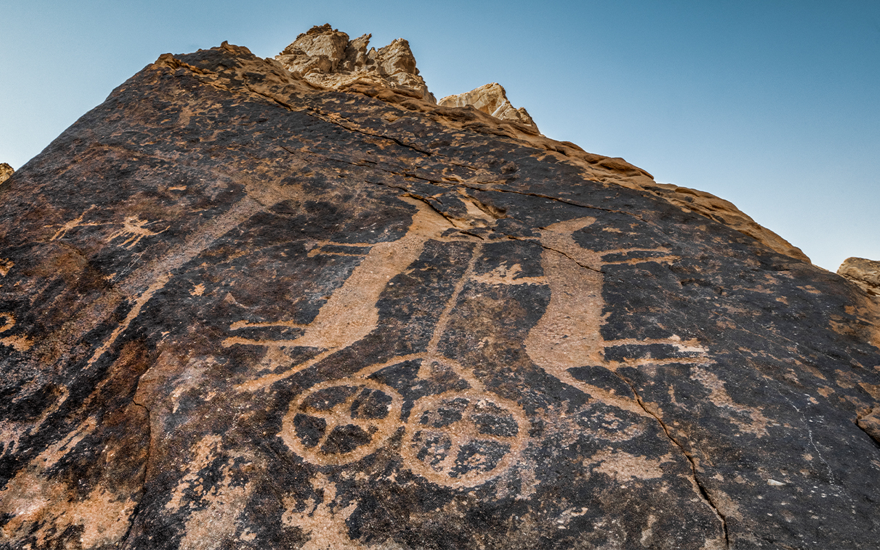
Specific inscriptions stand out on Umm Sinman mountain, such as the chariot inscription, which is considered one of the most significant drawings on the mountain. This depiction is of a chariot pulled by two horses. This drawing points to an advanced civilizational stage experienced by the ancestors of the Arabs in the northern Arabian Peninsula. The depiction dates back to the invention of the wheel in the fifth millennium BC in Sumer (about seven thousand years ago). Meanwhile, the use of horses to pull such chariots points to the second millennium BC in China (about four thousand years ago). The chariot was known in the Levant and Egypt around 1200 BC, which is approximately 3,200 years ago.
Al-Shuwaymis
Al-Shuwaymis represents one of the most prominent rock art sites in the Hail Province. It is located about three hundred km south of Hail, situated on the northern edge of Harrat al-Nar near Wadi al-Mukhait, which separates Harrat Layla from Harrat al-Nar. It is also close to the bottom of the race, the area that witnessed the longest and most fierce battle in Arab history: the battle of Dahis and al-Ghabraa.
The geography of al-Shuwaymis indicates that it consists of elevations made of sandstone. These elevations and the facades of fallen rocks house art depicting complete human figures. They sometimes appear individually or accompanied by animal forms (dogs). The human figures have oval-shaped heads or sometimes even resemble bird heads, often depicted in scenes that represent hunting activities. Furthermore, there are animal carvings, including (lions, leopards, donkeys, ibexes, dogs, and cattle with long horns). All of these have been sculpted through techniques like rubbing, chiseling, or carving, and are roughly life-sized.
The rock art at al-Shuwaymis distinguishes itself from other rock art sites in the region by its precision in execution and its beautiful friezes. One of these panels extends to about twelve m in length, encompassing human, animal, and geometric shapes. There are also beautifully carved human (both adults and children) and animal footprints on the surface of one of the stones located near the entrance of a cave. The ceiling of this cave features a collection of beautifully carved geometric shapes.
The area of al-Shuwaymis site exceeds fifty km². It is registered on UNESCO's World Heritage List. The archaeological inscriptions there date back to the Late Stone Age. The site boasts rock art characterized by human and animal sculptures that depict camels, horses, ibexes, and palm trees, in addition to Thamudic inscriptions. The carvings of men riding camels suggest the activity of trade caravans, and there are magnificent rock arts portraying humans in life size, alongside a diverse assortment of animals.
The archaeological area of al-Shuwaymis is abundant with caves and volcanic remnants. On the edge of Harret al-Nair, Sha'fan Cave is visible, and there are other caves around it that are comparable to Shafan in size and historical and archaeological value. So far, more than ten caves have been explored in the region. In addition, the area contains volcanic craters, with about twelve of them having been discovered.
The rock art and inscriptions in al-Shuwaymis span across three periods. The oldest dates back to the middle of the seventh millennium BC. Some belong to the Thamudic period, between 1500-2500 years ago from the present time, while others are from the Arabic period. These inscriptions and drawings were executed on rock facades using incising and deep carving techniques. They depict abstract human forms engaged in various activities and several types of animals that humans either used or hunted, such as wild cattle, ibexes, deer, ostriches, and mountain goats. Some of these depict adjacent abstract human figures, representing group celebrations, religious practices, war battles, and dual combats. Furthermore, these drawings frequently illustrate hunting practices and images of wild animals like lions and leopards.
Baqaa
Baqaa, located in the Hail Province, boasts several sites rich in diverse rock art, notably:
Al-Hamimiya mountains: They are situated forty-five km west of Baqaa city, to the left of the road leading from Baqaa to Hail. In general, they showcase a plethora of rock art, including depictions of camels, ibexes, wild cattle, lions, and various-sized human figures using hunting and combat tools.
Al-Remimenat mountains: They arelocated about thirty-five km southwest of Baqaa. They stand as a historic landmark that old caravans of travelers traversed on the ancient Baqaa-Hail route. English traveler Lady Anne Blunt mentioned it in her book A Journey to Najd, as did orientalists Alois Musil and Julius Euting, with the latter reproducing some of its inscriptions and rock art. The site is rich in rock art and inscriptions.
Bab al-Halah: It is a place or dwelling of the people, located near an area called Qawayim, southwest of the city of Baqaa. The site features numerous rock art pieces, illustrating various human and animal figures, some of which are executed in the Udi style.
Jildiyyah Mountain: It is situated approximately twenty-six km south of Baqaa City. On its rocks are numerous ancient Thamudic inscriptions and rock art depicting various human and animal forms that date back to prehistoric times. This mountain was mentioned in Arab poetry and in heritage books by historians and geographers, such as Abu Ali al-Hijri, al-Bakri, and al-Samhudi. Many orientalists passed by and described the mountain, including Doughty, Huber, Lady Anne Blunt, Musil, and Julius Euting.
Qaltat al-Zarqaa al-Fouqi: It is located roughly eleven km southwest of Baqaa City. The site is adorned with rock art representing ibexes, camels, wild cattle, and various-sized human figures wielding combat tools, along with many clear Thamudic inscriptions.
Ghiran Saadun: It is located twelve km south of the city of Baqaa. The site contains Thamudic inscriptions that are historically dated to 2500 years ago. Additionally, there is an Islamic engraving from the tenth century. The site boasts a large collection of rock art symbolizing hands in various sizes, engravings depicting animal hunting scenes, an engraving of a group of palm trees, and others showing human figures, ibexes, camels, tribal marks, and symbolic shapes that remain unidentified.
Fayd City
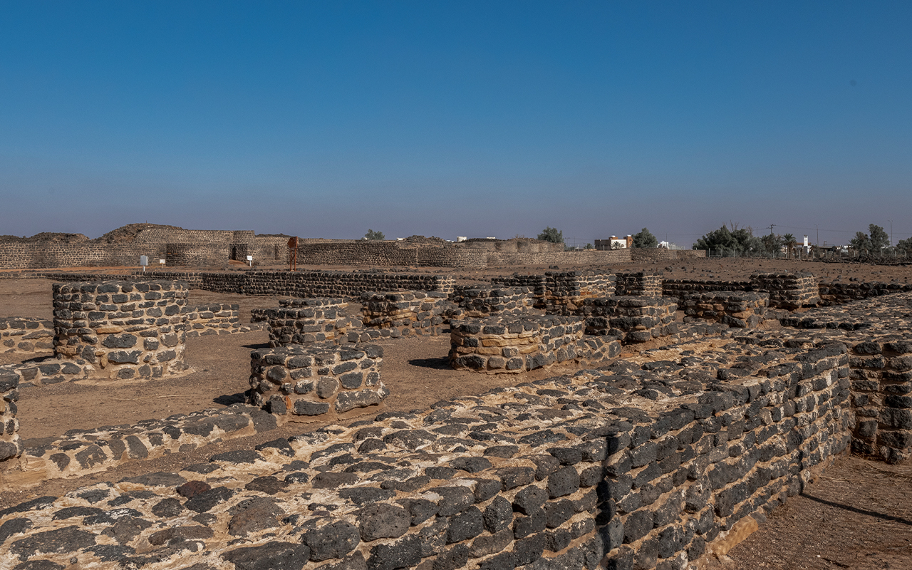
The city of Fayd is a prominent historical and archaeological city in the Hail Province. Located 120 km east of Hail city, it stands as the third city on the ancient pilgrimage route, known as the Zubaydah Trail, following Kufa and Basra. Fayd is the largest station on the Iraqi Hajj route (Zubaydah Trail).
The city of Fayd houses several distinguished historical and archaeological sites in the Hail Province. The remnants of old Faid town are situated 1.5 km north of the modern city. The archaeological site spans an area of about 1.5 km in length and a similar width.
Some historical sources suggest that the city of Fayd held a special significance during the Abbasid era. It was considered the third most important city after Baghdad and Makkah al-Mukarramah. This is because Faid is situated halfway between Makkah al-Mukarramah and Baghdad on the old Hajj route, also known as the Zubaydah Trail. This strategic location contributed to its prosperity as pilgrims passed through, replenishing their supplies from the city.
Other notable rock art sites
Hail Province is home to several archaeological sites that feature various types of rock art scattered throughout its expanse. Among these is:
Abraq Ghouth mountain: Located about four km north of the city of Mawqaq, this is a medium-height mountain surrounded by several smaller hills. To the north of this mountain, on one of the nearby hillocks, some rock art was discovered. These engravings predominantly depict men riding horses. South of this hillock, near the second unit, two well-preserved Thamudic inscriptions were found on one of the rocks located north of this unit.
Hutalah mountain: Located approximately five km northwest of the city of Muwaqqar, this is a massive, towering mountain. The only rock art found on the mountain is on its northern side, depicting a man riding a horse and holding a long spear, positioned as if about to attack.
Jarqouq mountain: Situated about fifteen km west of Muwaqqar, this is another massive, high-rising mountain. The site features stone ruins, with as many as eleven piles of stones, spread on both sides of a valley that slopes down from the southern top of the mountain.
Habashi mountain: Located about 175 km southeast of the city of Hail. Archaeological evidence discovered at the site suggests that it was inhabited since prehistoric times. A variety of stone tools have been found here, including axes, scrapers, drills, and stone arrowheads. All these tools belong to the stone tool-making techniques that were prevalent in the region during the New Stone Age.
Jatha Site: Positioned approximately 340 km southwest of Hail City and about fifteen km west of the sites of Rata and al-Munjoor. The facades of Jatha's mountains and the fallen rocks from them showcase human and animal figures (including long-horned cattle, donkeys, and ibexes), almost life-sized. They are executed by tapping or by carving the edges without hollowing out the inner parts, and they are believed to date back to the New Stone Age. In addition to these art, there are depictions of animals (camels and cattle) and ostriches. These sometimes appear individually or occasionally accompanying desert writings, also known to some as Thamudic inscriptions, executed almost life-sized using a rubbing technique and hollowing out the inner parts of the body. The site also contains several stone piles and circles.
Al-Dhubyah: Is a low plateau, extending from east to west in a semi-circular arc shape. Its facades and the facades of the fallen rocks from it contain many rock arts of animal figures including ibexes, dogs, and long-horned cattle. The style closely resembles the early Jubbah style and the sites west of al-Shuwaymis (Rata and al-Munjoor). The site also features figures of horses and camels, executed almost life-sized and in a style and size similar to what is found in the Mahja site located to the northwest of this location, approximately one hundred km away, which dates back to the Thamudic period.
Janin mountain: Located about sixty km northeast of the city of Hail, it houses a cave with a large number of rock art and inscriptions. Around the entrance of the cave, a collection of palm prints has been carved, which can be dated back to the Old Stone Age. Among the rock arts found in Janin are depictions of cattle, ibexes, and camels, in addition to human figures. The dancing scenes are considered among the most beautiful rock art panels in Janin, with five panels showcasing masked dancers.
Al-Malehiyah: It is one of the distinctive rock art sites in Hail Province. It contains depictions of cattle, deer with long horns, ibexes, and human figures executed in the Uthmani style. It also features wild cattle (Aurochs) depicted with all their natural details. In addition to this, there are representations of various animals, such as camels, horses, dogs, ostriches, and ibexes. The human figures portray groups of dancers, intertwined by their hands. These rock art may suggest religious rituals. The human depictions are not limited to dancing; there are also scenes of hunting. In al-Malehiyah, there are about twenty-nine inscriptions written in the Bedouin (Thamudic) script and in the Safawi script.
Mahjah: It is the name of a mountain range located 184 km northwest of al-Shamli. In this area, five sites have been discovered containing rock art of camels and horses, along with some hunting scenes. The site also has hundreds of ancient North Arabian inscriptions (Thamudic), and one of them mentions the name of the ancient Arabian deity (N H Y: Nahi).
Arnan mountains: Located about two km west of the town of al-Shamli, inscriptions written in the ancient North Arabian script (Thamudic) have been found here. Additionally, the rock art depicting human and animal figures found near water springs supports the idea that this site was inhabited during the second half of the first millennium BC.
Yatib mountain: Located about thirty km east of the city of Hail, this mountain contains a collection of archaeological evidence. On the slopes and summit of the mountain, there are numerous inscriptions in the ancient North Arabian script (Thamudic), with over 154 texts. Most of these inscriptions are commemorative in nature. Notably, there are two inscriptions: the first is written by a woman named Nuha bint Fasah. The second inscription mentions its author, Nawfal bin Ameel, expressing his longing and desire to meet his beloved, whose name he does not specify in the text. Yatib mountain and the surrounding archaeological sites are distinguished by the abundance and diversity of rock art. In addition to various representations of human figures, the site is rich in animal depictions, including sheep, camels, horses, and cattle.
Al-Asad mountain: This is a medium-height mountain where a significant amount of rock art is distributed across its rocky facades. These artworks primarily depict various animals such as camels, ibexes, lions, and human figures. In addition, there are several Thamudic inscriptions on the mountain. Six Thamudic inscriptions have been discovered at this site, with one of the most important and largest inscriptions being inscribed on a rock face overlooking a valley, consisting of nine lines.
Towal al-Khattah: This is a mountain range located about forty-five km north of the city of Hail. Three archaeological sites have been identified here. The first site contains twelve Thamudic inscriptions and one Islamic inscription written in the Kufic script. The second site has revealed four Thamudic inscriptions. The third site includes sixteen Thamudic inscriptions. These sites also contain rock art that portrays various animals, including ibexes, ostriches, dogs, and wild cattle.
Al-Dahwa: These are elevations made of sandstone that feature numerous rock paintings on their facades and the surfaces of nearby fallen rocks. Many of these artworks are no longer clearly visible due to the nature of these rocks which are susceptible to rapid erosion. The drawings mostly consist of arches and arrows, along with various animal figures (cattle, donkeys, and ibexes), depicted either individually or in groups. The style of these artworks closely resembles that of the early Jubbah style, especially the depictions of cattle.
Wadi Al-Jayb: Located about fifteen km northwest of the village of al-Dharwah, it is a valley surrounded by medium-height sandstone mountains. The facades of these mountains, as well as the nearby fallen rocks, host a large collection of rock art. These artworks primarily showcase human figures of nearly life-size proportions with oval heads or appearing as bird heads. They sometimes appear individually or in groups. The style closely resembles the early Jabba pattern, accompanied by drawings of animal figures (cattle, donkeys, and ibexes) that sometimes appear as herds.
Al-Qour Site: Located in the village of Iblah in al-Hait governorate, about nine km away, this area consists of elevations made of sandstone. Their facades, as well as the surfaces of nearby fallen rocks, feature rock art depicting human and animal figures (cattle and ibexes). Some of these rock arts sometimes accompany human figures holding bows and arrows. The rock drawings are spread across three locations: Western al-Qour located to the northwest of the village of Iblah. Northern al-Qour is situated in the northwest of the village. And the Western al-Qour in the northwest of the village of Iblah in al-Hait province. The archaeological site contains a few ancient Thamudic Arabic inscriptions.
Al-Ghuttah: These are mountain peaks surrounded by sand dunes on all sides, located ten km northeast of Jubbah. These peaks host a considerable number of rock artworks, showcasing human and animal figures, executed in various techniques and styles. The sunken carving style stands out among them, along with several short Thamudic inscriptions.
Khashm al-Qataa: These are elevated areas of sandstone whose facades, and the surfaces of the nearby fallen rocks, feature rock art depicting animal figures (cattle, lions, ibexes, dogs, and donkeys) carved in a sunken style. In addition, there are several almost life-sized human figures, sometimes depicted in motion without showing body or clothing details. They are often seen holding bows and arrows, appearing alone or accompanied by animal figures (cattle).
Al-Qaed mountain: Located thirty-five km north of the city of Hail, its slopes showcase various rock art of human and animal figures. It also contains eight archaeological sites, featuring a collection of ancient Northern Arabic inscriptions (Thamudic), totaling eighty-three inscriptions. All of these are commemorative inscriptions, except for one that speaks about an individual named Qabs committing the crime of killing another person whom he named Yishraeh in the text of the inscription.
Dile al-Asabea: These are several medium and small mountains with pointed peaks, located approximately eight km west of Jaldiah mountain. The site has a large number of Thamudic inscriptions and rock art. The site of al-Asabea has been visited by many orientalists, such as the French Huber and the German Julius Euting.
Shuayb al-Buwaib: Al-Buwaib is a diminutive form of the word Bab (door), and it was named this due to the narrowing of the stream's course between these mountains until it exits from a small outlet resembling a door. Some orientalists, like the French Charles Huber and the German Julius Euting, visited it 137 years ago. They copied some of the inscriptions and rock art found on the rock facades, described them, and illustrated them in their writings. The scholar Van den Branden also visited it, copying twenty-six Thamudic inscriptions.
Aba al-Sabban: Located about 250 km southwest of Hail city. Although most of the artifacts found at the site bear indications of the Islamic period, especially inscriptions and remnants of architectural structures, some of the rock art of human and animal figures suggest that the site of Aba al-Sabban was inhabited during the pre-Islamic era.
World Heritage Site
The rock art of the Hail Province was registered on the UNESCO World Heritage List in 2015, being the fourth archaeological site from the Kingdom to be listed, after Hegra, Diriyah, and Historic Jeddah. The global appreciation is attributed to its being a historical habitat for a large number of rock inscriptions, distributed between the Governorates of Jubbah, Ratah, and al-Mannjoor. The ingenuity of these drawings, crafted using stone hammers and primitive techniques, reflects the genius of the human mind. They also stand as an important testament to human resilience against environmental calamities.
Registered World Heritage Sites
Recognizing their historical and civilizational value, UNESCO, in its thirty-ninth session held in Bonn, Germany, included the rock art of the Hail Province in the World Heritage List. This was following the registration of Hegra, Diriyah, and Historic Jeddah. The site of Jubbah west of Hail and the site of al-Shuwaymis south of Hail were registered on the World Heritage List. This global acknowledgment underscores the importance of rock art sites in the Hail Province and in other parts of the Kingdom. These sites, particularly Jubbah and al-Shuwaymis, rank among the most important, oldest, and richest rock art sites globally.
Rock art sites in Hail represent cultural and historical value for the Kingdom and humanity. Those sites are considered a human creation that forms a cultural record of human communities across the various eras that have succeeded in the region. The rock art subjects are characterized by their quantity and manner. These arts reveal the social, cultural, and religious aspects of these human communities since prehistoric times, especially the Neolithic period, as seen in sites like Umm Sinman in Jubbah and al-Manjoor in al-Shuwaymis, both of which are registered on the World Heritage List. These sites also span historical periods, most notably the era of ancient Arabic writings (Thamudic) during the first millennium BC, as well as the early Islamic periods.
Touristic value
The rock art sites in Hail Province add significant touristic dimensions to explore the historical and civilizational facets within. They serve as open natural museums that receive care and attention from concerned entities. The Ministry of Tourism has erected fences around a set of rock art relics and inscriptions that date back thousands of years at the base of Umm Sinman mountain in Jubbah.
Rock art tourism
Given the stunning nature of the Hail Province and the surrounding rock art sites, it has become a unique tourist destination. There are a number of sites that have started attracting tourists, such as:
Yatib mountain: An important tourist site. It is located thirty km east of the city of Hail. This archaeological site dates back to the third millennium BC. The site's touristic significance stems from its collection of Thamudic rock drawings and inscriptions.
Mountain and Cave of Janin: This is considered a tourist site in the Hail Province. It is renowned as it contains one of the oldest archaeological caves that were inhabited by prehistoric humans in the Hail Province. The site also hosts a collection of artistic mural paintings, expressing varied themes, formations, and elements in their rock drawings and inscriptions.
Al-Huait: Located on the foothills of the lava fields of Khaybar al-Sharqi, south of al-Hait, it is about 280 km southwest of Hail city. From a touristic perspective, it is as significant as al-Hait. It is considered one of the oldest cultural archaeological sites in the region. Historically, al-Huait was known as Yedea, and it dates back to two periods: The pre-Islamic period, represented by the Thamudic drawings and writings scattered on the flint stones throughout the site. An early Islamic period, represented by the remnants of the ancient city.
Caves and lava fields
In the Hail Province, there are a number of caves and lava fields that contain inscriptions and rock drawings, making them tourist destinations. Among the most prominent is the Janin Cave. On the edge of the lava fields of al-Nar, Shuafan cave emerges, and its spacious mouth appears as one of the largest caves in the Kingdom. The cave stretches over two km in length, rising up to eight m and descending to eight hundred m below ground. It contains winding side routes whose end lengths are unknown. There are other caves, comparable in size and historical and archaeological value to Shuafan, scattered around it. To date, over ten of these caves have been explored. Additionally, the region contains volcanic craters; about twelve craters have been discovered.
There are several mountains and caves in al-Shuwaymis region that are adorned with archaeological inscriptions. Among the most notable are:
Al-Nar lava fields: This archaeological site was discovered in 2001 by the Bedouins living there. They observed carvings on the mountains. Subsequent studies confirmed that these drawings date back over fourteen thousand years.
Shuafan Cave: It's one of the largest archaeological caves in the Kingdom. The cave stretches approximately one thousand five hundred m underground. Its height and width range from ten to twelve m, but in some places, the height drops to half a meter, and the width narrows to about one and a half meters. This cave is considered one of the primary tourist attractions in al-Shuwaymis.
Geography of Hail
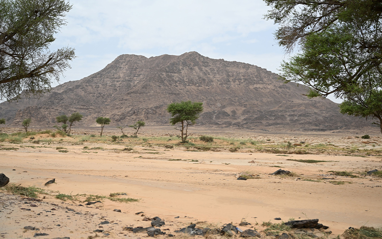
Hail Provence boasts a unique geographical location, situated in the north-central part of the Kingdom. It covers an area of approximately 118,220 km². The city of Hail lies at the center of this region and is about six hundred km from Riyadh, 450 km from al-Madinah al-Munawwarah, and 650 km from Tabuk. It has an elevation of around nine hundred fifteen m above sea level, which grants it a moderate climate. The region is bordered by two predominant mountain ranges: the Aja Mountains to the west and the Salma Mountains to the southeast.
The city of Hail is located between the Aja Mountains to the west of the Hail valley. It is bordered to the north by the northern border region and al-Jouf, to the south and east by al-Qassim Province, and to the west by the Tabuk and al-Madinah al-Munawwarah regions. For centuries, Hail was one of the most important desert cities, as it served as the main transit point for pilgrims heading to the two holy cities, Makkah al-Mukarramah and al-Madinah al-Munawwarah. It was also a significant hub for traders traveling either north or south in the Arabian Peninsula.
This geographical location provided the city and the region with the opportunity to connect with the outside world through various means, such as traders, writers, poets, and pilgrims. This interaction resulted in a vibrant historical and urban tapestry. Some of the earliest inhabitants left traces of their presence, manifested in ancient tools and rock art that date back nearly ten thousand years.
Hail Province boasts a significant natural diversity, characterized by its rich terrains, including caves, mountains, plains, and volcanoes. This has established it as one of the vital tourist regions in the Kingdom and a destination for various tourist and sports activities.
History of Hail
The name Hail originally referred to the valley upon which the city is situated. Historically, it was known as The Village or The Village of Hail. Over time, people began to omit the term village and started referring to it by the name of its valley, Hail. One explanation for the name suggests that the valley, now known as al-Aderea, used to form a barrier between the inhabitants of Aja and Salma when it flooded. One of the most notable figures associated with Hail is the legendary Hatim al-Taei, who is renowned for his boundless generosity.
Due to its strategic geographical location and the availability of natural resources in its surroundings, Hail has been a settlement for various communities throughout history. The habitation of the region dates back to the Stone Age. Its suitable environment played a significant role in attracting and favoring human settlements.
This history spans numerous eras and periods. Since the first millennium BC, the region of Hail has been a crossroads for caravans traveling the route that stretches from the East to the West across the peninsula, as well as the route between the north and south that traverses Mesopotamia and Yemen. By the twelfth century, it became an essential route for pilgrims from Iraq and Syria heading to al-Madinah al-Munawwarah and Makkah al-Mukarramah.
Historically, Hail was recognized as one of the most fortified places in the Arabian Peninsula, which protected it from invasions by the kings of al-Hirah in Iraq and the Ghassanid kings in the Levant. Eventually, King Abdulaziz Bin Abdulrahman annexed it in 1922 to what would become the Kingdom, which he unified in 1932. Since that time, the region has enjoyed peace and stability.
Hail is a flourishing agricultural oasis where crops like grains, dates, and fruits thrive. Its irrigated fields represent the primary source of wheat in the Kingdom. Moreover, Hail is home to many historical and cultural landmarks, including Qal'at A'irif, a fortress dating back over two hundred years. In addition to these, there are several sites listed in UNESCO's World Heritage list.
Sources
United Nations Educational, Scientific and Cultural.
King Faisal Center for Research and Islamic Studies